| Station catalog metadata [edit] | [station overview] |
|---|
| SSC ID | SSC-make |
| Station Name | Makemo |
| Country | French Polynesia |
| Latitude | -16.6269 |
| Longitude | -143.5691 |
| DateLastModified | 2015-10-22 19:02:29 |
| Linked codes |
|---|
| Codes | Location | Latitude | Longitude | Sensors |
IOC: make | Makemo (Polynésie française, Tuamotu) | -16.6269 | -143.5691 | prs, rad, bat |
GLOSS: 354 | | | | |
UHSLC: 454 | Makemo | -16.598 | -143.662 | N/A |
PTWC: make | Makemo_French_Poly | -16.6269 | -143.5691 | prs, rad |
PSMSL: 2368 | MAKEMO | -16.626998 | -143.569212 | N/A |
SONEL_GPS: 3417 | MAKEMO | -16.62699800 | -143.56921200 | N/A |
SONEL_TG: 3416 | MAKEMO | -16.62699800 | -143.56921200 | N/A |
| Distributed metadata source: IOC Sea Level Station Monitoring Facility make |
|---|
| GTS station code | FAA04758 |
| GTS message type | SEHI40 |
| Status | Operational |
| Local Contact | University of French Polynesia ( France ) |
| Other Contact | Service hydrographique et océanographique de la marine ( France ) |
| Other Contact | Commissariat à l'Energie Atomique ( France ) |
| Connection | GTS message |
| Country | Polynésie Française (French Polynesia) |
| Sensor 1 | |
| Type of sensor | prs |
| Sampling rate (min) | 1 |
| Sensor 2 | |
| Type of sensor | rad |
| Sampling rate (min) | 1 |
| Sensor 3 | |
| Type of sensor | bat |
| Sampling rate (min) | 5 |
| Distributed metadata source: GLOSS Station Handbook |
|---|
| Distributed metadata source: PTWC COMP META file |
| DCP ID | FAA04758 |
| WMO | SEHI40 |
| Samp Rate | 1 |
| Num# Samp | 5 |
| Unit | M |
| Scale | 1.0000 |
| Xmt Int. | 005 |
| Fst Min. | 0045 |
| HAR | 1 |
| Owner | SHOM |
| Distributed metadata source: UHSLC |
| UHSLC id | 454 |
| SSC id | make |
| GLOSS id | 354 |
| UHSLC geojson | https://uhslc.soest.hawaii.edu/data/meta.geojson |
| Fast delivery | 2019-01-01 - 2026-04-30 |
| Distributed metadata source: PSMSL |
| Name | MAKEMO |
| GLOSS id | 354 |
| Is RLR | Y |
| Has RLR Diagram | Y link |
| QC Flag | N |
| Last Updated | 2026-02-20 |
| Supplier | SERVICE HYD. ET OCEAN. DE LA MARINE |
| Address | SHOM, 13 rue de Chatelier, 29200 BREST , FRANCE |
| Metric Start | 2015 |
| Metric End | 2025 |
| Metric Completeness | 40.2 |
| RLR Start | 2015 |
| RLR End | 2025 |
| RLR Completeness | 40.2 |
| Download metric sea level data. | Use only with extreme caution. |
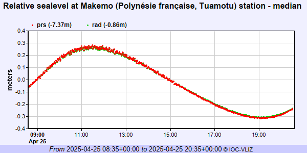
IOC Sea Level Station Monitoring Facility - realtime graph for 'make'
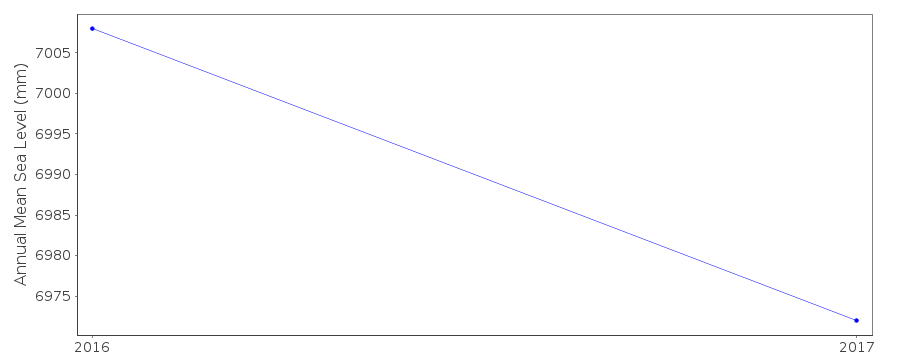
PSMSL Annual Mean Sea Level for '2368'
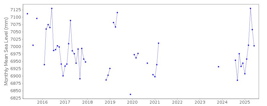
PSMSL Monthly Mean Sea Level for '2368'