 |
SEALEVEL STATION CATALOG (SSC) |
|
|
|
|
|
| Station catalog metadata [edit] | [station overview] |
|---|
| SSC ID | SSC-maer | | Station Name | Marmara Ereglisi | | Country | Turkey | | Latitude | 40.966667 | | Longitude | 27.966667 | | DateLastModified | 2015-10-22 19:02:29 |
| Linked codes |
|---|
| Codes | Location | Latitude | Longitude | Sensors | IOC: maer | Marmara Ereglisi | 40.96896672 | 27.96215236 | rad |
PSMSL: 2010 | MARMARA EREGLISI | 40.966667 | 27.966667 | N/A |
SONEL_GPS: 2028 | MARMARA EREGLESI | 40.96666700 | 27.96666700 | N/A |
SONEL_TG: 2175 | MARMARA EREGLESI | 40.96700000 | 27.96700000 | N/A |
| Distributed metadata source: IOC Sea Level Station Monitoring Facility maer |
|---|
| Status | Operational |
| Local Contact | General Directorate of Mapping ( Turkey ) |
| Other Contact | Kandilli Observatory and Earthquake Research Institute ( Turkey ) |
| Connection | WEB service |
| Country | Turkey |
| Sensor 1 | |
| Type of sensor | rad |
| Sampling rate (min) | 0.5 |
| Distributed metadata source: PSMSL |
| Name | MARMARA EREGLISI |
| Is RLR | Y |
| Has RLR Diagram | Y link |
| QC Flag | N |
| Old ID | 310/037 |
| Last Updated | 2010-06-28 |
| Supplier | GENERAL DIRECTORATE OF MAPPING |
| Address | General Directorate of Mapping, Tlp Fakultesi Cad, 06590 Cebeci/Cankaya, Ankara, TÜRKİYE |
| Metric Start | 2004 |
| Metric End | 2009 |
| Metric Completeness | 79.2 |
| RLR Start | 2004 |
| RLR End | 2009 |
| RLR Completeness | 79.2 |
| Download metric sea level data. | Use only with extreme caution. |
IOC Sea Level Station Monitoring Facility - realtime graph for 'maer' 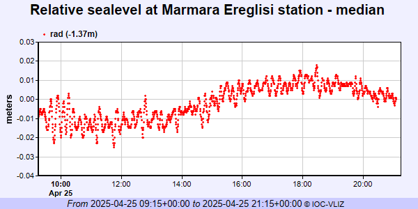 PSMSL Annual Mean Sea Level for '2010' 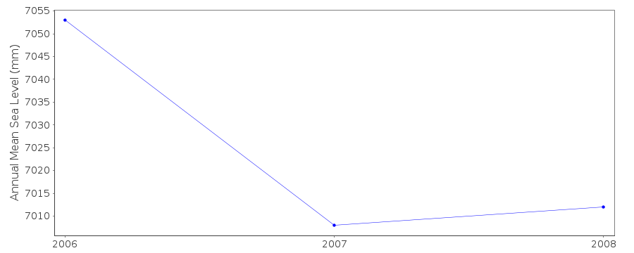 PSMSL Monthly Mean Sea Level for '2010' 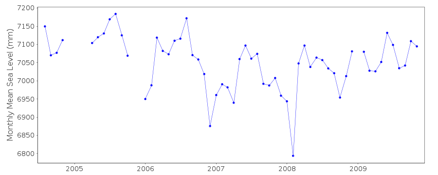
|
|
|