 |
SEALEVEL STATION CATALOG (SSC) |
|
|
|
|
|
| Station catalog metadata [edit] | [station overview] |
|---|
| SSC ID | SSC-lusi | | Station Name | Lusi | | Country | China | | Latitude | 32.13333 | | Longitude | 121.61666 | | DateLastModified | 2015-10-22 19:02:29 |
| Distributed metadata source: GLOSS Station Handbook |
|---|
| Time Zone | 120E, GMT + 8hrs | | Ocean | Pacific | | Operational | Yes | | Data acquisition rate | Recording at hourly intervals | | Additional parameters | Surface T and S, wave and meteorological parameters | | Tide gauge benchmarks | TGBM (LZBM) was used from January 1973 to July 1980, and is about 6km from the tide gauge. Since then a new TGBM has been used - details not available. | | Benchmark relationships | Tide Gauge Zero (TGZ) = 6.110m below TGBM (LZBM)
TGZ = 7.573m below TGBM (NEW) after 1 July 1980
TGZ = 2.863m below MSL of Yellow Sea (1956-old)
TGZ = 2.902m below MSL of Yellow Sea (1985-new)
| | Auxiliary benchmarks | SU-IV-282-1 is about 7km from the tide gauge and 5.489m above the MSL of the Yellow Sea (1985-new). | | Other relevant codes | UHSLC 633 | | Nearest Met. station | Lusi |
| Distributed metadata source: UHSLC |
| UHSLC id | 633 |
| SSC id | lusi |
| GLOSS id | 283 |
| UHSLC geojson | https://uhslc.soest.hawaii.edu/data/meta.geojson |
| Research quality data version a | 1975-01-01 - 1996-10-30 |
| RQ basin | pacific |
| Distributed metadata source: PSMSL |
| Name | LUSI |
| GLOSS id | 283 |
| UHSLC ID | 633 |
| Is RLR | Y |
| Has RLR Diagram | Y link |
| QC Flag | Y |
| Old ID | 610/032 |
| Last Updated | 2022-01-05 |
| Supplier | NATIONAL MARINE DATA AND INFORMATION SERVICE (NMDIS) |
| Address | National Marine Data and Information Service (NMDIS), No. 93 Liuwei Road, Tianjin 300171, CHINA |
| Metric Start | 1961 |
| Metric End | 2020 |
| Metric Completeness | 84.4 |
| RLR Start | 1961 |
| RLR End | 2020 |
| RLR Completeness | 83.6 |
| Download metric sea level data. | Use only with extreme caution. |
PSMSL Annual Mean Sea Level for '979' 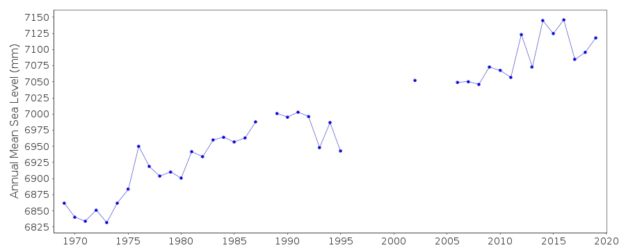 PSMSL Monthly Mean Sea Level for '979' 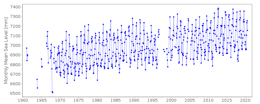
|
|
|