 |
SEALEVEL STATION CATALOG (SSC) |
|
|
|
|
|
| Station catalog metadata [edit] | [station overview] |
|---|
| SSC ID | SSC-lerw | | Station Name | Lerwick | | Country | United Kingdom | | Latitude | 60.155316 | | Longitude | -1.145192 | | DateLastModified | 2015-10-22 19:02:29 |
| Distributed metadata source: IOC Sea Level Station Monitoring Facility lerw |
|---|
| Status | Down |
| Local Contact | National Oceanography Centre ( UK ) |
| Connection | SOCKET |
| Country | UK |
| Sensor 1 | |
| Type of sensor | bub |
| Sampling rate (min) | 0.1667 |
| Sensor 2 | |
| Type of sensor | bub1 |
| Sampling rate (min) | 0.1667 |
| Distributed metadata source: IOC Sea Level Station Monitoring Facility lerw2 |
|---|
| Status | Operational |
| Local Contact | National Oceanography Centre ( UK ) |
| Connection | FTP box |
| Country | UK |
| Sensor 1 | |
| Type of sensor | bub |
| Sampling rate (min) | 15 |
| Distributed metadata source: GLOSS Station Handbook |
|---|
| Time Zone | 000E, GMT | | Ocean | Atlantic | | Operational | Yes | | Tide gauge benchmarks | Ordnance Survey Benchmark bolt on breakwater wall.
Ordnance Survey Grid Reference: HU 4783 4129
| | Benchmark relationships | Tide Gauge Zero = Admiralty Chart Datum (ACD)
Tide Gauge Zero = 1.22m below local Ordnance Datum
Tide Gauge Zero = 4.57m below Tide Gauge Benchmark (from 1989 onwards)
| | Auxiliary benchmarks | AUX 1: On SW face (south angle) of Queens Hotel. OS Grid Reference HU 4784 4125
AUX 2: On N face (north west angle) of Lerwick Parish Church. OS Grid Reference HU 4777 4110
Rivet: Set in concrete on north east angle of tide gauge hut.
| | Other relevant codes | UHSLC 293 | | Nearest Met. station | Sumburgh |
| Distributed metadata source: UHSLC |
| UHSLC id | 293 |
| SSC id | lerw |
| GLOSS id | 236 |
| UHSLC geojson | https://uhslc.soest.hawaii.edu/data/meta.geojson |
| Research quality data version a | 1959-01-01 - 2016-11-26 |
| RQ basin | atlantic |
| Fast delivery | 1959-01-01 - 2013-11-30 |
| Distributed metadata source: PSMSL |
| Name | LERWICK |
| GLOSS id | 236 |
| UHSLC ID | 293 |
| SONEL id | 4408 |
| Is RLR | Y |
| Has RLR Diagram | Y link |
| QC Flag | N |
| Old ID | 170/001 |
| Last Updated | 2026-02-19 |
| Supplier | ENVIRONMENT AGENCY |
| Address | Environment Agency, Horizon House, Deanery Road, BS1 5AH, Bristol, UNITED KINGDOM |
| Metric Start | 1957 |
| Metric End | 2025 |
| Metric Completeness | 85.6 |
| RLR Start | 1957 |
| RLR End | 2025 |
| RLR Completeness | 85.6 |
| Download metric sea level data. | Use only with extreme caution. |
IOC Sea Level Station Monitoring Facility - realtime graph for 'lerw'  IOC Sea Level Station Monitoring Facility - realtime graph for 'lerw2' 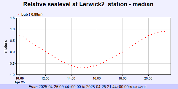 PSMSL Annual Mean Sea Level for '830' 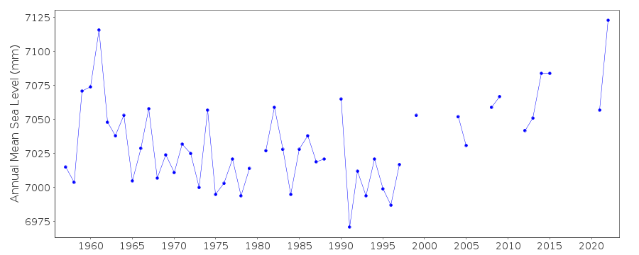 PSMSL Monthly Mean Sea Level for '830' 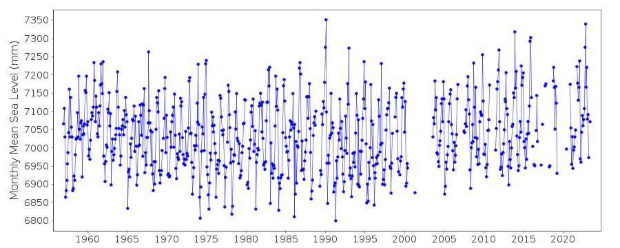
|
|
|