 |
SEALEVEL STATION CATALOG (SSC) |
|
|
|
|
|
| Station catalog metadata [edit] | [station overview] |
|---|
| SSC ID | SSC-laru | | Station Name | Pointe La Rue | | Country | Seychelles | | Latitude | -4.68333 | | Longitude | 55.51666 | | DateLastModified | 2015-10-22 19:02:29 |
| Linked codes |
|---|
| Codes | Location | Latitude | Longitude | Sensors | IOC: laru2 | Point LaRue | -4.672 | 55.528 | prs, rad, enc, bat, sw1, sw2, ra2, stp |
GLOSS: 339 | Pointe La Rue | -4.67166 | 55.52666 | Float |
UHSLC: 111 | Port Victoria | -4.622 | 55.458 | N/A |
UHSLC: 121 | Pt. La Rue | -4.672 | 55.528 | N/A |
PTWC: laru | Pt.LaRue_SC | -4.6762 | 55.5294 | prs, rad, enc, ra2 |
PSMSL: 1846 | POINT LA RUE | -4.666667 | 55.533333 | N/A |
SONEL_GPS: 3407 | SEYCHELLES | -4.67873183 | 55.53063053 | N/A |
SONEL_GPS: 838 | SEYCHELLES | -4.67371921 | 55.47940389 | N/A |
SONEL_TG: 1977 | SEYCHELLES | -4.67645400 | 55.52942300 | N/A |
| Distributed metadata source: IOC Sea Level Station Monitoring Facility laru2 |
|---|
| GTS station code | 12FD90D0 |
| GTS message type | SXXX32 |
| Status | Operational |
| Local Contact | Seychelles National Meteorological Services ( Seychelles ) |
| Other Contact | University of Hawaii Sea Level Center ( USA ) |
| Connection | GTS message |
| Country | Seychelles |
| Sensor 1 | |
| Type of sensor | prs |
| Sampling rate (min) | 1 |
| Sensor 2 | |
| Type of sensor | rad |
| Sampling rate (min) | 3 |
| Sensor 3 | |
| Type of sensor | enc |
| Sampling rate (min) | 6 |
| Sensor 4 | |
| Type of sensor | ra2 |
| Sampling rate (min) | 6 |
| Sensor 5 | |
| Type of sensor | sw1 |
| Sampling rate (min) | 60 |
| Sensor 6 | |
| Type of sensor | sw2 |
| Sampling rate (min) | 60 |
| Sensor 7 | |
| Type of sensor | bat |
| Sampling rate (min) | 6 |
| Sensor 8 | |
| Type of sensor | stp |
| Sampling rate (min) | 6 |
| Distributed metadata source: GLOSS Station Handbook |
|---|
| Time Zone | GMT + 4hrs | | Ocean | Indian | | Operational | Yes | | Responsible country | Seychelles | | Additional parameters | The only oceanographic observations are tide, sea level monitoring and sea temperature measurement. Further Marine and oceanographic activities are carried out by other organizations. | | Tide gauge benchmarks | Tide Gauge location 04 40.3' S and 055 31.7' E.
Tide Gauge GLOSS number 273, Toga I053, NODC II 30054502 replaced old tide gauge located at Port Victoria, it is a float/ well, Handar 436-A, Encoder 436-B. | | Other relevant information | Tide Gauge was installed on 11th of January 1993.
Tide Gauge samples every second and averages every one minute, and transmits the data every 15 min to University of Hawaii through Meteosat 7 and GOES satellite. | | Other relevant codes | UHLSC 121 |
| Distributed metadata source: PTWC COMP META file |
| DCP ID | 12FD90D0 |
| WMO | SXXX32 |
| Samp Rate | 6 |
| Num# Samp | 10 |
| Unit | M |
| Scale | 1.0000 |
| Xmt Int. | 006 |
| Fst Min. | 0000 |
| HAR | 1 |
| Owner | UHSLC |
| Distributed metadata source: UHSLC |
| UHSLC id | 111 |
| SSC id | laru |
| GLOSS id | 339 |
| UHSLC geojson | https://uhslc.soest.hawaii.edu/data/meta.geojson |
| Research quality data version a | 1977-12-16 - 1982-12-31 |
| Research quality data version b | 1986-05-29 - 1992-12-30 |
| RQ basin | indian |
| UHSLC id | 121 |
| SSC id | laru |
| GLOSS id | 339 |
| UHSLC geojson | https://uhslc.soest.hawaii.edu/data/meta.geojson |
| Research quality data version a | 1993-01-11 - 2018-12-31 |
| RQ basin | indian |
| Fast delivery | 1993-01-11 - 2026-04-30 |
| Distributed metadata source: PSMSL |
| Name | POINT LA RUE |
| GLOSS id | 339 |
| UHSLC ID | 121 |
| SONEL id | 838 |
| Is RLR | Y |
| Has RLR Diagram | Y link |
| QC Flag | N |
| Old ID | 442/007 |
| Last Updated | 2020-01-29 |
| Supplier | UNIVERSITY OF HAWAII SEA LEVEL CENTER |
| Address | University of Hawaii Sea Level Center, Department of Oceanography Division of Natural Sciences, 1000 Pope Road, Honolulu, Hawaii 96822, UNITED STATES |
| Metric Start | 1993 |
| Metric End | 2018 |
| Metric Completeness | 98.4 |
| RLR Start | 1993 |
| RLR End | 2018 |
| RLR Completeness | 98.4 |
| Download metric sea level data. | Use only with extreme caution. |
IOC Sea Level Station Monitoring Facility - realtime graph for 'laru2' 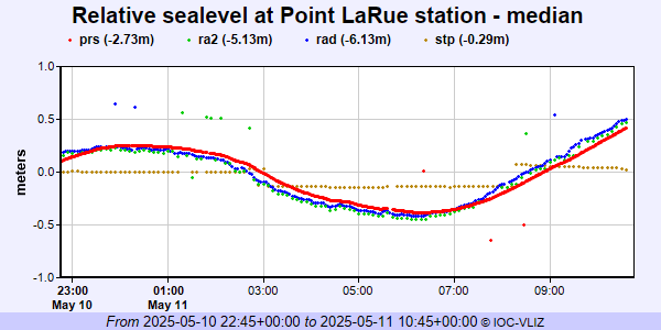 PSMSL Annual Mean Sea Level for '1846' 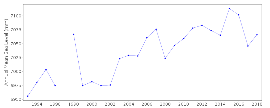 PSMSL Monthly Mean Sea Level for '1846' 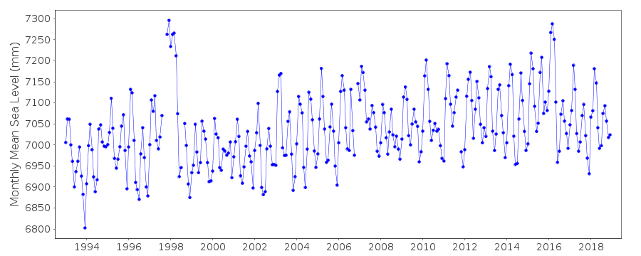
|
|
|