 |
SEALEVEL STATION CATALOG (SSC) |
|
|
|
|
|
| Station catalog metadata [edit] | [station overview] |
|---|
| SSC ID | SSC-lame | | Station Name | Lameshur Bay | | Country | United States | | Latitude | 18.3182 | | Longitude | -64.7242 | | DateLastModified | 2021-12-10 17:19:12 |
| Linked codes |
|---|
| Codes | Location | Latitude | Longitude | Sensors | IOC: lame | LameshurBayStJohnVI | 18.3182 | -64.7242 | pwl |
IOC: lame2 | LameshurBayStJohnVI | 18.3182 | -64.7242 | pwl |
UHSLC: 214 | Lameshur Bay | 18.3167 | -64.7233 | N/A |
PTWC: lame | LameshurBayStJohnVI | 18.3182 | -64.7242 | pwc, pwl, bwl |
PSMSL: 2119 | LAMESHUR BAY | 18.316667 | -64.723333 | N/A |
| Distributed metadata source: IOC Sea Level Station Monitoring Facility lame |
|---|
| GTS station code | 335D10EA |
| GTS message type | SXXX03 |
| Status | Operational |
| Local Contact | National Ocean Service-NOAA ( USA ) |
| Other Contact | International Tsunami Information Center Caribbean Office ( USA ) |
| Connection | WEB service |
| Country | USA |
| Sensor 1 | |
| Type of sensor | pwl |
| Sampling rate (min) | 1 |
| Distributed metadata source: IOC Sea Level Station Monitoring Facility lame2 |
|---|
| GTS station code | 335D10EA |
| GTS message type | SXXX03 |
| Status | Incorrect data |
| Local Contact | National Ocean Service-NOAA ( USA ) |
| Other Contact | International Tsunami Information Center Caribbean Office ( USA ) |
| Connection | GTS message |
| Country | USA |
| Sensor 1 | |
| Type of sensor | pwl |
| Sampling rate (min) | 1 |
| Distributed metadata source: PTWC COMP META file |
| DCP ID | 335D10EA |
| WMO | SXXX03 |
| Samp Rate | 6 |
| Num# Samp | 1 |
| Unit | M |
| Scale | 1.3763 |
| Xmt Int. | 006 |
| Fst Min. | 0003 |
| HAR | 1 |
| Owner | NOS |
| Distributed metadata source: UHSLC |
| UHSLC id | 214 |
| SSC id | lame |
| UHSLC geojson | https://uhslc.soest.hawaii.edu/data/meta.geojson |
| Research quality data version a | 2006-08-03 - 2022-12-31 |
| RQ basin | atlantic |
| Distributed metadata source: PSMSL |
| Name | LAMESHUR BAY |
| UHSLC ID | 214 |
| Is RLR | Y |
| Has RLR Diagram | Y link |
| QC Flag | N |
| Old ID | 939/021 |
| Last Updated | 2026-01-28 |
| Supplier | N.O.A.A. / N.O.S. |
| Address | N.O.A.A. / N.O.S., N/oes33, Ssmc4, Room 6531, 1305 East-West Highway, Silver Spring, , MD 20910, UNITED STATES |
| Metric Start | 2006 |
| Metric End | 2025 |
| Metric Completeness | 92.1 |
| RLR Start | 2006 |
| RLR End | 2025 |
| RLR Completeness | 92.1 |
| Download metric sea level data. | Use only with extreme caution. |
IOC Sea Level Station Monitoring Facility - realtime graph for 'lame' 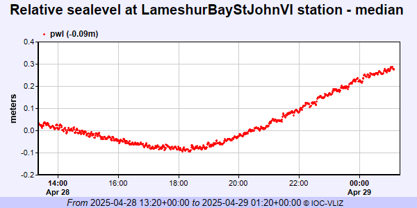 IOC Sea Level Station Monitoring Facility - realtime graph for 'lame2' 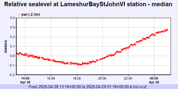 PSMSL Annual Mean Sea Level for '2119' 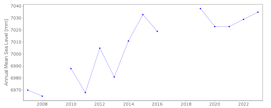 PSMSL Monthly Mean Sea Level for '2119' 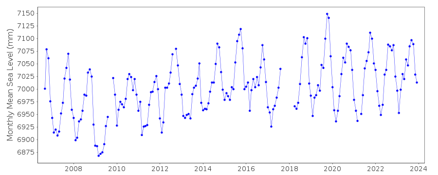
|
|
|