 |
SEALEVEL STATION CATALOG (SSC) |
|
|
|
|
|
| Station catalog metadata [edit] | [station overview] |
|---|
| SSC ID | SSC-kwfl | | Station Name | Key West | | Country | United States | | Latitude | 24.553 | | Longitude | -81.808 | | DateLastModified | 2015-10-22 19:02:29 |
| Distributed metadata source: IOC Sea Level Station Monitoring Facility kwfl |
|---|
| Status | Operational |
| Local Contact | National Ocean Service-NOAA ( USA ) |
| Connection | WEB service |
| Country | USA |
| Sensor 1 | |
| Type of sensor | pwl |
| Sampling rate (min) | 1 |
| Distributed metadata source: IOC Sea Level Station Monitoring Facility kwfl2 |
|---|
| GTS station code | 334E966E |
| GTS message type | SXXX03 |
| Status | Down |
| Local Contact | National Ocean Service-NOAA ( USA ) |
| Connection | GTS message |
| Country | USA |
| Sensor 1 | |
| Type of sensor | pwl |
| Sampling rate (min) | 1 |
| Distributed metadata source: GLOSS Station Handbook |
|---|
| Time Zone | 075W, GMT - 5hrs | | Ocean | Atlantic | | Operational | Yes | | Data acquisition rate | 6 minute intervals | | Additional parameters | Sea surface temperature and density | | Tide gauge benchmarks | US C&GS tidal benchmark survey disk stamped '29 1923 8.140' set in a concrete wall of the Naval Officers’ Q and T Buildings at the corner of Eaton and Emma Streets, Key West, FL. | | Benchmark relationships | TGBM = 8.73 feet above mean lower low water (1960-1978 epoch)
TGBM = 7.81 feet above mean sea level (1960-1978 epoch)
TGBM = 7.18 feet above mean high water (1960-1978 epoch)
| | Auxiliary benchmarks | NO 1 1974 30 1923 16.417
NO 2 1974 32 1929 7.083
124 1923 6.529 '14.324'
125 1923 5.292 4580 A 1978
126 1923 9.482 4580 AA 1978
127 1923 8.274
| | Other relevant codes | UHSLC 242 |
| Distributed metadata source: PTWC COMP META file |
| DCP ID | 334E966E |
| WMO | SXXX20 |
| Samp Rate | 6 |
| Num# Samp | 1 |
| Unit | M |
| Scale | 1.0000 |
| Xmt Int. | 006 |
| Fst Min. | 0004 |
| HAR | 1 |
| Owner | NOS |
| Distributed metadata source: UHSLC |
| UHSLC id | 242 |
| SSC id | keyw |
| GLOSS id | 216 |
| UHSLC geojson | https://uhslc.soest.hawaii.edu/data/meta.geojson |
| Research quality data version a | 1913-01-19 - 2021-12-31 |
| RQ basin | atlantic |
| Fast delivery | 1913-01-19 - 2026-05-31 |
| Distributed metadata source: PSMSL |
| Name | KEY WEST |
| GLOSS id | 216 |
| UHSLC ID | 242 |
| SONEL id | 2969 |
| Is RLR | Y |
| Has RLR Diagram | Y link |
| QC Flag | N |
| Old ID | 940/071 |
| Last Updated | 2026-01-27 |
| Supplier | N.O.A.A. / N.O.S. |
| Address | N.O.A.A. / N.O.S., N/oes33, Ssmc4, Room 6531, 1305 East-West Highway, Silver Spring, , MD 20910, UNITED STATES |
| Metric Start | 1913 |
| Metric End | 2025 |
| Metric Completeness | 99.3 |
| RLR Start | 1913 |
| RLR End | 2025 |
| RLR Completeness | 99.3 |
| Download metric sea level data. | Use only with extreme caution. |
IOC Sea Level Station Monitoring Facility - realtime graph for 'kwfl' 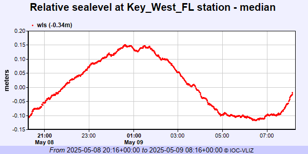 IOC Sea Level Station Monitoring Facility - realtime graph for 'kwfl2'  PSMSL Annual Mean Sea Level for '188' 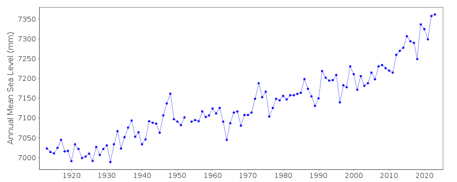 PSMSL Monthly Mean Sea Level for '188' 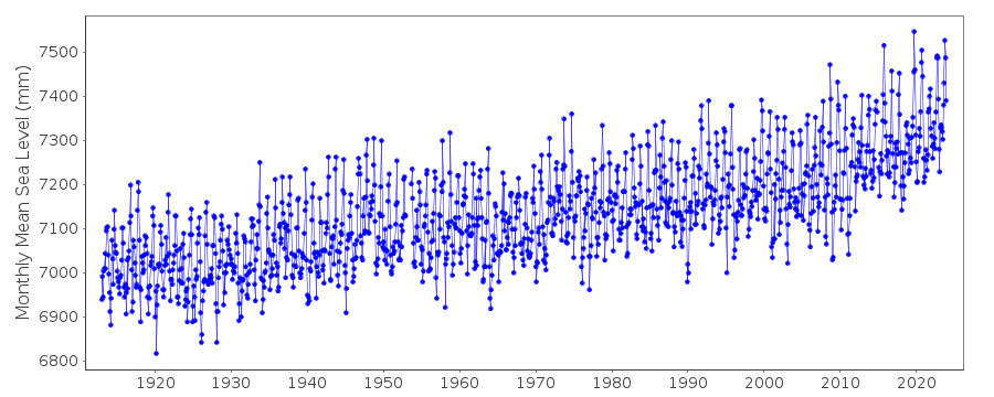
|
|
|