 |
SEALEVEL STATION CATALOG (SSC) |
|
|
|
|
|
| Station catalog metadata [edit] | [station overview] |
|---|
| SSC ID | SSC-kwaj | | Station Name | Kwajalein | | Country | Marshall Islands | | Latitude | 8.7367 | | Longitude | 167.7383 | | DateLastModified | 2015-10-22 19:02:29 |
| Linked codes |
|---|
| Codes | Location | Latitude | Longitude | Sensors | IOC: kwaj | Kwajalein_MH | 8.7367 | 167.7383 | wls |
IOC: kwaj2 | Kwajalein_MH | 8.7367 | 167.7383 | pwl |
GLOSS: 111 | Kwajalein | 8.73333 | 167.73333 | Float, Bubbler, Acoustic |
UHSLC: 55 | Kwajalein | 8.7333 | 167.7333 | N/A |
PTWC: kwaj | Kwajalein_MH | 8.7320 | 167.7340 | pwc, pwl, bwl |
PSMSL: 513 | KWAJALEIN | 8.731667 | 167.735 | N/A |
SONEL_GPS: 717 | KWAJALEIN | 8.72220621 | 167.73024105 | N/A |
SONEL_TG: 2301 | KWAJALEIN | 8.73198800 | 167.73425000 | N/A |
| Distributed metadata source: IOC Sea Level Station Monitoring Facility kwaj |
|---|
| GTS station code | 3362A386 |
| GTS message type | SXXX03 |
| Status | Operational |
| Local Contact | National Ocean Service-NOAA ( USA ) |
| Connection | WEB service |
| Country | Marshall Islands |
| Sensor 1 | |
| Type of sensor | wls |
| Sampling rate (min) | 1 |
| Distributed metadata source: IOC Sea Level Station Monitoring Facility kwaj2 |
|---|
| GTS station code | 3362A386 |
| GTS message type | SXXX03 |
| Status | Operational |
| Local Contact | National Ocean Service-NOAA ( USA ) |
| Connection | GTS message |
| Country | Marshall Islands |
| Sensor 1 | |
| Type of sensor | pwl |
| Sampling rate (min) | 1 |
| Distributed metadata source: GLOSS Station Handbook |
|---|
| Time Zone | 180E, GMT + 12hrs | | Ocean | Pacific | | Operational | Yes | | Additional parameters | Air/sea surface temp, density pressure, wind speed/ direction | | Tide gauge benchmarks | Benchmark 8 (1957) is the primary benchmark (PBM) set in the north side of the former sea wall of Echo Pier. | | Benchmark relationships | TGBM is 9.36ft above Tide Gauge Zero (Station Datum)
NOAA Chart Datum (MLLW) is 2.83ft above Station Datum
Mean Sea Level (1960-1978) is 4.73ft above Station Datum
| | Other relevant codes | UHSLC 055 |
| Distributed metadata source: PTWC COMP META file |
| DCP ID | 3362A386 |
| WMO | SXXX03 |
| Samp Rate | 6 |
| Num# Samp | 1 |
| Unit | M |
| Scale | 1.0000 |
| Xmt Int. | 006 |
| Fst Min. | 0002 |
| HAR | 1 |
| Owner | NOS |
| Distributed metadata source: UHSLC |
| UHSLC id | 055 |
| SSC id | kwaj |
| GLOSS id | 111 |
| UHSLC geojson | https://uhslc.soest.hawaii.edu/data/meta.geojson |
| Research quality data version a | 1946-06-07 - 2021-12-31 |
| RQ basin | pacific |
| Fast delivery | 1946-06-07 - 2026-05-31 |
| Distributed metadata source: PSMSL |
| Name | KWAJALEIN |
| GLOSS id | 111 |
| UHSLC ID | 55 |
| SONEL id | 717 |
| Is RLR | Y |
| Has RLR Diagram | Y link |
| QC Flag | N |
| Old ID | 720/011 |
| Last Updated | 2026-01-28 |
| Supplier | N.O.A.A. / N.O.S. |
| Address | N.O.A.A. / N.O.S., N/oes33, Ssmc4, Room 6531, 1305 East-West Highway, Silver Spring, , MD 20910, UNITED STATES |
| Metric Start | 1946 |
| Metric End | 2025 |
| Metric Completeness | 98.1 |
| RLR Start | 1946 |
| RLR End | 2025 |
| RLR Completeness | 98.1 |
| Download metric sea level data. | Use only with extreme caution. |
IOC Sea Level Station Monitoring Facility - realtime graph for 'kwaj' 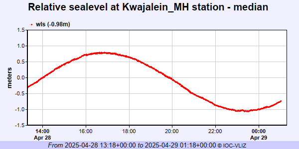 IOC Sea Level Station Monitoring Facility - realtime graph for 'kwaj2'  PSMSL Annual Mean Sea Level for '513'  PSMSL Monthly Mean Sea Level for '513' 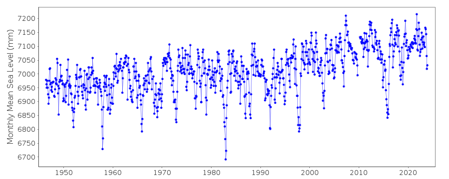
|
|
|