 |
SEALEVEL STATION CATALOG (SSC) |
|
|
|
|
|
| Station catalog metadata [edit] | [station overview] |
|---|
| SSC ID | SSC-kuan | | Station Name | Kuantan | | Country | Malaysia | | Latitude | 3.98333 | | Longitude | 103.43333 | | DateLastModified | 2015-10-22 19:02:29 |
| Linked codes |
|---|
| Codes | Location | Latitude | Longitude | Sensors | UHSLC: 322 | Kuantan | 3.975 | 103.43 | N/A |
PSMSL: 1589 | TANJUNG GELANG | 3.975 | 103.43 | N/A |
| Distributed metadata source: UHSLC |
| UHSLC id | 322 |
| SSC id | kuan |
| UHSLC geojson | https://uhslc.soest.hawaii.edu/data/meta.geojson |
| Research quality data version a | 1983-12-21 - 2019-07-28 |
| RQ basin | pacific |
| Distributed metadata source: PSMSL |
| Name | TANJUNG GELANG |
| UHSLC ID | 322 |
| Is RLR | Y |
| Has RLR Diagram | Y link |
| QC Flag | N |
| Old ID | 550/014 |
| Last Updated | 2019-09-11 |
| Supplier | DEPARTMENT OF SURVEY AND MAPPING |
| Address | Department of Survey and Mapping, Wisma JUPEM, Jalan Semarak, 50578 Kuala Lumpur, MALAYSIA |
| Metric Start | 1984 |
| Metric End | 2018 |
| Metric Completeness | 98.6 |
| RLR Start | 1984 |
| RLR End | 2018 |
| RLR Completeness | 98.6 |
| Download metric sea level data. | Use only with extreme caution. |
PSMSL Annual Mean Sea Level for '1589' 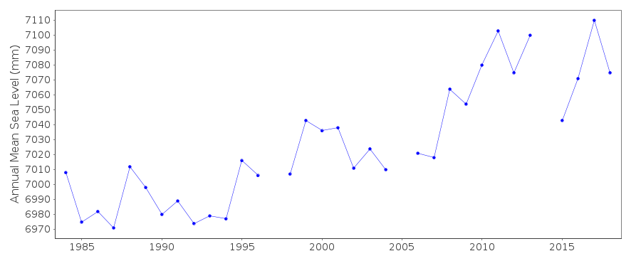 PSMSL Monthly Mean Sea Level for '1589' 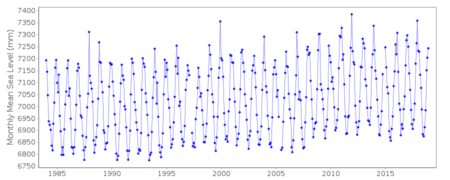
|
|
|