 |
SEALEVEL STATION CATALOG (SSC) |
|
|
|
|
|
| Station catalog metadata [edit] | [station overview] |
|---|
| SSC ID | SSC-kota | | Station Name | Ko Taphao Noi | | Country | Thailand | | Latitude | 7.8167 | | Longitude | 98.4167 | | DateLastModified | 2015-10-22 19:02:29 |
| Linked codes |
|---|
| Codes | Location | Latitude | Longitude | Sensors | IOC: kota | Ko Taphao Noi | 7.8167 | 98.4167 | prs, rad, bat, sw1, sw2, enc |
GLOSS: 42 | Ko Taphao Noi | 7.83333 | 98.43333 | Float |
UHSLC: 148 | Ko Taphao Noi | 7.832 | 98.425 | N/A |
PTWC: kota | | | | |
PSMSL: 2230 | PANWA CAPE | 7.801389 | 98.406389 | N/A |
PSMSL: 446 | KO TAPHAO NOI | 7.833333 | 98.433333 | N/A |
SONEL_TG: 2807 | KO TAPHAO NOI | 7.83377500 | 98.42158200 | N/A |
| Distributed metadata source: IOC Sea Level Station Monitoring Facility kota |
|---|
| GTS station code | 0650879A |
| GTS message type | SZTH40 |
| Status | Down |
| Local Contact | Royal Thai Navy ( Thailand ) |
| Other Contact | University of Hawaii Sea Level Center ( USA ) |
| Connection | GTS message |
| Country | Thailand |
| Sensor 1 | |
| Type of sensor | prs |
| Sampling rate (min) | 1 |
| Sensor 2 | |
| Type of sensor | rad |
| Sampling rate (min) | 3 |
| Sensor 3 | |
| Type of sensor | enc |
| Sampling rate (min) | 5 |
| Sensor 4 | |
| Type of sensor | sw1 |
| Sampling rate (min) | 60 |
| Sensor 5 | |
| Type of sensor | sw2 |
| Sampling rate (min) | 60 |
| Sensor 6 | |
| Type of sensor | bat |
| Sampling rate (min) | 6 |
| Distributed metadata source: GLOSS Station Handbook |
|---|
| Time Zone | 105E, GMT + 7hrs | | Ocean | Indian | | Operational | Yes | | Responsible country | Thailand | | Data acquisition rate | Continuous recording | | Additional parameters | None | | Tide gauge benchmarks | Royal Thai survey department benchmark B.M.S. 1319 is at the west side of Ko Taphao Noi. It is a nail in a concrete block. | | Benchmark relationships | M.S.L. at Ko Lak | | Auxiliary benchmarks | B.M. 101 = 2.9200m above mean sea level at Ko Lak
B.M. 105 = 2.9155m above mean sea level at Ko Lak
| | Other relevant codes | UHSLC 148 | | Nearest Met. station | Phuket |
| Distributed metadata source: PTWC COMP META file |
| DCP ID | |
| WMO | |
| Samp Rate | |
| Num# Samp | |
| Unit | |
| Scale | |
| Xmt Int. | |
| Fst Min. | |
| HAR | |
| Owner | |
| Distributed metadata source: UHSLC |
| UHSLC id | 148 |
| SSC id | kota |
| GLOSS id | 42 |
| UHSLC geojson | https://uhslc.soest.hawaii.edu/data/meta.geojson |
| Research quality data version a | 1985-01-01 - 2019-12-30 |
| RQ basin | indian |
| Fast delivery | 1985-01-01 - 2025-12-31 |
| Distributed metadata source: PSMSL |
| Name | PANWA CAPE |
| UHSLC ID | 148 |
| Is RLR | Y |
| Has RLR Diagram | Y link |
| QC Flag | N |
| Old ID | 545/002 |
| Last Updated | 2015-07-02 |
| Supplier | OCEANOGRAPHIC DIVISION, HYDROGRAPHIC DEPT. |
| Address | Oceanographic Division, Hydrographic Department, Royal Thai Navy, 222 Rimtang-Rodfai-kao Road, Bangna, Bangkok 10260, THAILAND |
| Metric Start | 2013 |
| Metric End | 2014 |
| Metric Completeness | 83.3 |
| RLR Start | 2013 |
| RLR End | 2014 |
| RLR Completeness | 83.3 |
| Download metric sea level data. | Use only with extreme caution. |
| Name | KO TAPHAO NOI |
| GLOSS id | 42 |
| UHSLC ID | 148 |
| Is RLR | Y |
| Has RLR Diagram | Y link |
| QC Flag | N |
| Old ID | 545/001 |
| Last Updated | 2025-08-04 |
| Supplier | OCEANOGRAPHIC DIVISION, HYDROGRAPHIC DEPT. |
| Address | Oceanographic Division, Hydrographic Department, Royal Thai Navy, 222 Rimtang-Rodfai-kao Road, Bangna, Bangkok 10260, THAILAND |
| Metric Start | 1940 |
| Metric End | 2024 |
| Metric Completeness | 93.8 |
| RLR Start | 1940 |
| RLR End | 2024 |
| RLR Completeness | 93.8 |
| Download metric sea level data. | Use only with extreme caution. |
IOC Sea Level Station Monitoring Facility - realtime graph for 'kota'  PSMSL Annual Mean Sea Level for '2230'  PSMSL Annual Mean Sea Level for '446' 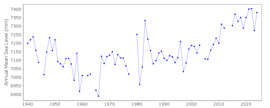 PSMSL Monthly Mean Sea Level for '446' 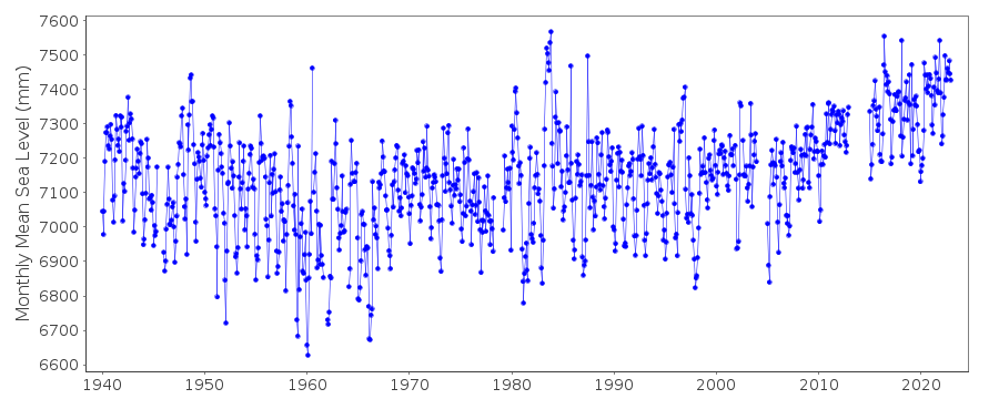
|
|
|