 |
SEALEVEL STATION CATALOG (SSC) |
|
|
|
|
|
| Station catalog metadata [edit] | [station overview] |
|---|
| SSC ID | SSC-kepo | | Station Name | King Edward Point | | Country | United Kingdom | | Latitude | -54.28 | | Longitude | -36.5 | | DateLastModified | 2015-10-22 19:02:29 |
| Linked codes |
|---|
| Codes | Location | Latitude | Longitude | Sensors | IOC: kepo | King Edward Point | -54.28 | -36.5 | pr1, pr2 |
IOC: kepo1 | King Edward Point | -54.28 | -36.5 | rad, pr1, pr2, atm, bat |
GLOSS: 187 | South Georgia | -54.25 | -36.75 | Pressure |
PTWC: kepo | King_Edward_Point_UK | -54.2800 | -36.5000 | pr1, pr2, rad |
PSMSL: 896 | KING EDWARD POINT | -54.283292 | -36.496756 | N/A |
SONEL_GPS: 3411 | KING EDWARD POINT | -54.29520000 | -36.51430000 | N/A |
SONEL_TG: 2861 | KING EDWARD POINT | -54.28000000 | -36.50000000 | N/A |
| Distributed metadata source: IOC Sea Level Station Monitoring Facility kepo |
|---|
| Status | Down |
| Local Contact | British Antartic Survey ( UK ) |
| Other Contact | National Oceanography Centre ( UK ) |
| Connection | FTP box |
| Country | UK |
| Sensor 1 | |
| Type of sensor | pr1 |
| Sampling rate (min) | 1 |
| Sensor 2 | |
| Type of sensor | pr2 |
| Sampling rate (min) | 1 |
| Distributed metadata source: IOC Sea Level Station Monitoring Facility kepo1 |
|---|
| GTS station code | 6B002B74 |
| GTS message type | SEMS40 |
| Status | Operational |
| Local Contact | British Antartic Survey ( UK ) |
| Other Contact | National Oceanography Centre ( UK ) |
| Connection | GTS message |
| Country | UK |
| Sensor 1 | |
| Type of sensor | rad |
| Sampling rate (min) | 1 |
| Sensor 2 | |
| Type of sensor | pr1 |
| Sampling rate (min) | 1 |
| Sensor 3 | |
| Type of sensor | pr2 |
| Sampling rate (min) | 1 |
| Sensor 4 | |
| Type of sensor | atm |
| Sampling rate (min) | 15 |
| Sensor 5 | |
| Type of sensor | bat |
| Sampling rate (min) | 15 |
| Distributed metadata source: GLOSS Station Handbook |
|---|
| Operational | Yes | | Other relevant information | Installed at King Edward's Point |
| Distributed metadata source: PTWC COMP META file |
| DCP ID | 6B002B74 |
| WMO | SEMS40 |
| Samp Rate | 1 |
| Num# Samp | 15 |
| Unit | M |
| Scale | 1.0000 |
| Xmt Int. | 015 |
| Fst Min. | 0003 |
| HAR | 1 |
| Owner | NOC |
| Distributed metadata source: PSMSL |
| Name | KING EDWARD POINT |
| GLOSS id | 187 |
| SONEL id | 3411 |
| Is RLR | N |
| Has RLR Diagram | N link |
| QC Flag | N |
| Old ID | 866/001 |
| Last Updated | 2021-02-02 |
| Supplier | N.O.C. |
| Address | British Oceanographic Data Centre, National Oceanography Centre, Joseph Proudman Building, 6 Brownlow Street, Liverpool, L3 5DA, UNITED KINGDOM |
| Metric Start | 1957 |
| Metric End | 2020 |
| Metric Completeness | 20.1 |
| Download metric sea level data. | Use only with extreme caution. |
IOC Sea Level Station Monitoring Facility - realtime graph for 'kepo'  IOC Sea Level Station Monitoring Facility - realtime graph for 'kepo1' 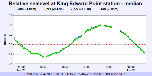 PSMSL Annual Mean Sea Level for '896'  PSMSL Monthly Mean Sea Level for '896' 
|
|
|