 |
SEALEVEL STATION CATALOG (SSC) |
|
|
|
|
|
| Station catalog metadata [edit] | [station overview] |
|---|
| SSC ID | SSC-kaum | | Station Name | Kaumalapau | | Country | United States | | Latitude | 20.78 | | Longitude | -156.9 | | DateLastModified | 2015-10-22 19:02:29 |
| Linked codes |
|---|
| Codes | Location | Latitude | Longitude | Sensors | IOC: kaum | Kaumalapau, Hawaii | 20.78 | -156.9 | prs, rad, bat, sw1, sw2 |
UHSLC: 548 | Kaumalapau, HI | 20.783 | -157 | N/A |
PTWC: kaum | | | | |
PSMSL: 2273 | LANAI ISLAND, KAUMALAPAU | 20.78 | -156.9 | N/A |
| Distributed metadata source: IOC Sea Level Station Monitoring Facility kaum |
|---|
| GTS station code | 3542C242 |
| GTS message type | SEPO40 |
| Status | Down |
| Local Contact | University of Hawaii Sea Level Center ( USA ) |
| Connection | GTS message |
| Country | USA |
| Sensor 1 | |
| Type of sensor | prs |
| Sampling rate (min) | 1 |
| Sensor 2 | |
| Type of sensor | rad |
| Sampling rate (min) | 1 |
| Sensor 3 | |
| Type of sensor | sw1 |
| Sampling rate (min) | 60 |
| Sensor 4 | |
| Type of sensor | sw2 |
| Sampling rate (min) | 60 |
| Sensor 5 | |
| Type of sensor | bat |
| Sampling rate (min) | 5 |
| Distributed metadata source: PTWC COMP META file |
| DCP ID | |
| WMO | |
| Samp Rate | |
| Num# Samp | |
| Unit | |
| Scale | |
| Xmt Int. | |
| Fst Min. | |
| HAR | |
| Owner | |
| Distributed metadata source: UHSLC |
| UHSLC id | 548 |
| SSC id | kaum |
| UHSLC geojson | https://uhslc.soest.hawaii.edu/data/meta.geojson |
| Research quality data version a | 2007-07-15 - 2015-03-22 |
| RQ basin | pacific |
| Fast delivery | 2007-07-15 - 2015-03-22 |
| Distributed metadata source: PSMSL |
| Name | LANAI ISLAND, KAUMALAPAU |
| UHSLC ID | 429 |
| Is RLR | Y |
| Has RLR Diagram | Y link |
| QC Flag | N |
| Old ID | 760/043 |
| Last Updated | 2018-02-28 |
| Supplier | UNIVERSITY OF HAWAII SEA LEVEL CENTER |
| Address | University of Hawaii Sea Level Center, Department of Oceanography Division of Natural Sciences, 1000 Pope Road, Honolulu, Hawaii 96822, UNITED STATES |
| Metric Start | 2007 |
| Metric End | 2015 |
| Metric Completeness | 85.2 |
| RLR Start | 2010 |
| RLR End | 2015 |
| RLR Completeness | 86.1 |
| Download metric sea level data. | Use only with extreme caution. |
IOC Sea Level Station Monitoring Facility - realtime graph for 'kaum'  PSMSL Annual Mean Sea Level for '2273' 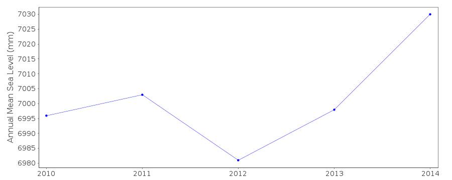 PSMSL Monthly Mean Sea Level for '2273' 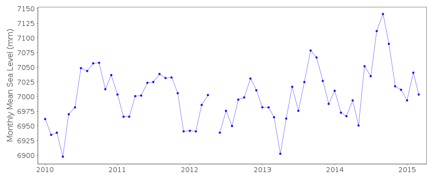
|
|
|