 |
SEALEVEL STATION CATALOG (SSC) |
|
|
|
|
|
| Station catalog metadata [edit] | [station overview] |
|---|
| SSC ID | SSC-kapi | | Station Name | Kapingamarangi | | Country | Micronesia | | Latitude | 1.0779583 | | Longitude | 154.8066861 | | DateLastModified | 2015-10-22 19:02:29 |
| Linked codes |
|---|
| Codes | Location | Latitude | Longitude | Sensors | IOC: kapi | Kapingamarangi_FM | 1.0779583 | 154.8066861 | prs, rad, ra2, ras, enc, sw1, sw2, bat |
GLOSS: 117 | Kapingamarangi, Caroline Is. | 1.1 | 154.78333 | Float |
UHSLC: 29 | Kapingamarangi | 1.098 | 154.777 | N/A |
PTWC: kapi | Kapingamarangi_FM | 1.0780 | 154.8067 | prs, ra2, rad, ras |
PSMSL: 1473 | KAPINGAMARANGI | 1.1 | 154.783333 | N/A |
SONEL_TG: 2841 | KAPINGAMARANGI | 1.07791500 | 154.80668500 | N/A |
| Distributed metadata source: IOC Sea Level Station Monitoring Facility kapi |
|---|
| GTS station code | 300434064787540 |
| GTS message type | SZXX01 |
| Status | Operational |
| Local Contact | Yap Weather Service Office ( Federated States of Micronesia ) |
| Other Contact | University of Hawaii Sea Level Center ( USA ) |
| Connection | GTS message |
| Country | Micronesia |
| Sensor 1 | |
| Type of sensor | prs |
| Sampling rate (min) | 1 |
| Sensor 2 | |
| Type of sensor | rad |
| Sampling rate (min) | 1 |
| Sensor 3 | |
| Type of sensor | ra2 |
| Sampling rate (min) | 1 |
| Sensor 4 | |
| Type of sensor | ras |
| Sampling rate (min) | 1 |
| Sensor 5 | |
| Type of sensor | enc |
| Sampling rate (min) | 1 |
| Sensor 6 | |
| Type of sensor | sw1 |
| Sampling rate (min) | 60 |
| Sensor 7 | |
| Type of sensor | sw2 |
| Sampling rate (min) | 60 |
| Sensor 8 | |
| Type of sensor | bat |
| Sampling rate (min) | 5 |
| Distributed metadata source: GLOSS Station Handbook |
|---|
| Time Zone | 165E, GMT + 11hrs | | Ocean | Pacific | | Operational | Yes | | Additional parameters | None | | Tide gauge benchmarks | UH1: SS disc set in grey epoxy, no markings, directly over tide staff, 8 inches from edge of quay. | | Auxiliary benchmarks | UH2: SS disc set in grey epoxy, no markings, 39 ft E of tide house 10 inches from edge of quay.
RM2: 3 inch aluminium disc, bearing 5D, 20ft 8 inches from staff at edge of quay.
DMA31471: 3 inch aluminium disc, bearing 70D, 49 ft from staff at centre of quay.
| | Other relevant information | Backup gauge on site: Handar encoder ADR (July 1985-)
Daily values calculated using 119-point convolution filter (Bloomfield, 1976) centred on noon applied to the hourly data with respective periods of 95, 50 and 5% amplitude points at 124.0, 60.2 and 40.2 hours.
| | Other relevant codes | UHSLC 029 |
| Distributed metadata source: PTWC COMP META file |
| DCP ID | 300434064787540 |
| WMO | SZXX01 |
| Samp Rate | 1 |
| Num# Samp | 5 |
| Unit | M |
| Scale | 1.0000 |
| Xmt Int. | 005 |
| Fst Min. | 0001 |
| HAR | 1 |
| Owner | UHSLC |
| Distributed metadata source: UHSLC |
| UHSLC id | 029 |
| SSC id | kapi |
| GLOSS id | 117 |
| UHSLC geojson | https://uhslc.soest.hawaii.edu/data/meta.geojson |
| Research quality data version a | 1978-09-09 - 2018-12-04 |
| RQ basin | pacific |
| Fast delivery | 1978-09-09 - 2026-04-30 |
| Distributed metadata source: PSMSL |
| Name | KAPINGAMARANGI |
| GLOSS id | 117 |
| UHSLC ID | 29 |
| Is RLR | Y |
| Has RLR Diagram | Y link |
| QC Flag | Y |
| Old ID | 710/026 |
| Last Updated | 2020-01-29 |
| Supplier | UNIVERSITY OF HAWAII SEA LEVEL CENTER |
| Address | University of Hawaii Sea Level Center, Department of Oceanography Division of Natural Sciences, 1000 Pope Road, Honolulu, Hawaii 96822, UNITED STATES |
| Metric Start | 1978 |
| Metric End | 2018 |
| Metric Completeness | 82.1 |
| RLR Start | 1978 |
| RLR End | 2018 |
| RLR Completeness | 82.1 |
| Download metric sea level data. | Use only with extreme caution. |
IOC Sea Level Station Monitoring Facility - realtime graph for 'kapi' 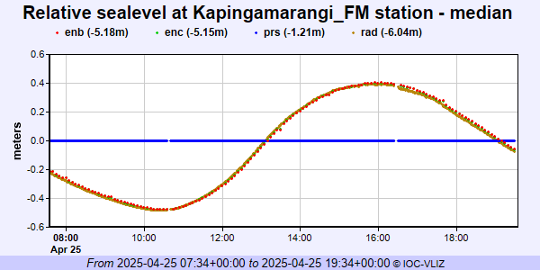 PSMSL Annual Mean Sea Level for '1473' 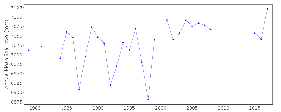 PSMSL Monthly Mean Sea Level for '1473' 
|
|
|