 |
SEALEVEL STATION CATALOG (SSC) |
|
|
|
|
|
| Station catalog metadata [edit] | [station overview] |
|---|
| SSC ID | SSC-kaoh | | Station Name | Kaohsiung | | Country | Taiwan (Province of China) | | Latitude | 22.61666 | | Longitude | 120.28333 | | DateLastModified | 2024-01-03 10:24:01 |
| Linked codes |
|---|
| Codes | Location | Latitude | Longitude | Sensors | IOC: tkao | Kaohsiung | 22.6144 | 120.2883 | rad |
UHSLC: 340 | Kaohsiung | 22.615 | 120.2883 | N/A |
PSMSL: 1356 | KAOHSIUNG II | 22.533333 | 120.316667 | N/A |
PSMSL: 152 | KAOHSIUNG | 22.616667 | 120.266667 | N/A |
| Distributed metadata source: IOC Sea Level Station Monitoring Facility tkao |
|---|
| Status | Operational |
| Local Contact | Central Weather Administration ( Taiwan ) |
| Connection | WEB service |
| Country | Taiwan (Province of China) |
| Sensor 1 | |
| Type of sensor | rad |
| Sampling rate (min) | 60 |
| Distributed metadata source: UHSLC |
| UHSLC id | 340 |
| SSC id | kaoh |
| UHSLC geojson | https://uhslc.soest.hawaii.edu/data/meta.geojson |
| Research quality data version a | 1980-01-01 - 2016-12-31 |
| RQ basin | pacific |
| Fast delivery | 1980-01-01 - 2016-12-31 |
| Distributed metadata source: PSMSL |
| Name | KAOHSIUNG II |
| UHSLC ID | 340 |
| Is RLR | Y |
| Has RLR Diagram | Y link |
| QC Flag | N |
| Old ID | 612/012 |
| Last Updated | 1998-04-28 |
| Supplier | CENTRAL WEATHER BUREAU |
| Address | Central Weather Bureau, 64 Kung Yuan Road, Taipei, Taiwan 10039, TAIWAN, PROVINCE OF CHINA |
| Metric Start | 1973 |
| Metric End | 1996 |
| Metric Completeness | 97.9 |
| RLR Start | 1973 |
| RLR End | 1989 |
| RLR Completeness | 97.1 |
| Download metric sea level data. | Use only with extreme caution. |
| Name | KAOHSIUNG |
| UHSLC ID | 340 |
| Is RLR | N |
| Has RLR Diagram | N link |
| QC Flag | N |
| Old ID | 612/011 |
| Last Updated | 1990-02-14 |
| Supplier | CENTRAL WEATHER BUREAU |
| Address | Central Weather Bureau, 64 Kung Yuan Road, Taipei, Taiwan 10039, TAIWAN, PROVINCE OF CHINA |
| Metric Start | 1904 |
| Metric End | 1973 |
| Metric Completeness | 92.3 |
| Download metric sea level data. | Use only with extreme caution. |
IOC Sea Level Station Monitoring Facility - realtime graph for 'tkao' 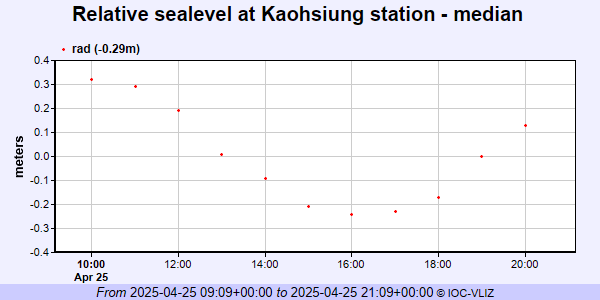 PSMSL Annual Mean Sea Level for '1356' 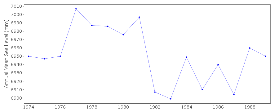 PSMSL Annual Mean Sea Level for '152'  PSMSL Monthly Mean Sea Level for '152' 
|
|
|