 |
SEALEVEL STATION CATALOG (SSC) |
|
|
|
|
|
| Station catalog metadata [edit] | [station overview] |
|---|
| SSC ID | SSC-kant | | Station Name | Kanton | | Country | Kiribati | | Latitude | -2.801 | | Longitude | -171.718 | | DateLastModified | 2015-10-22 19:02:29 |
| Linked codes |
|---|
| Codes | Location | Latitude | Longitude | Sensors | IOC: kant | Kanton_KI | -2.801 | -171.718 | prs, rad, ra2, ra3, ras, sw1, bat, stp |
GLOSS: 145 | Kanton Is., Phoenix Is. | -2.49 | -171.43 | Float |
UHSLC: 13 | Kanton | -2.80758 | -171.71425 | N/A |
PTWC: kant | Kanton_KI | -2.8010 | -171.7180 | prs, ra2, ra3, rad |
PSMSL: 1329 | KANTON ISLAND-B | -2.816667 | -171.716667 | N/A |
PSMSL: 575 | KANTON ISLAND | -2.8 | -171.716667 | N/A |
SONEL_TG: 2847 | KANTON ISLAND | -2.80100000 | -171.71800000 | N/A |
| Distributed metadata source: IOC Sea Level Station Monitoring Facility kant |
|---|
| GTS station code | 300434064782560 |
| GTS message type | SZXX01 |
| Status | Operational |
| Local Contact | Kiribati Met Office ( Kiribati ) |
| Other Contact | University of Hawaii Sea Level Center ( USA ) |
| Connection | GTS message |
| Country | Kiribati |
| Sensor 1 | |
| Type of sensor | prs |
| Sampling rate (min) | 1 |
| Sensor 2 | |
| Type of sensor | rad |
| Sampling rate (min) | 1 |
| Sensor 3 | |
| Type of sensor | ra2 |
| Sampling rate (min) | 1 |
| Sensor 4 | |
| Type of sensor | ra3 |
| Sampling rate (min) | 1 |
| Sensor 5 | |
| Type of sensor | ras |
| Sampling rate (min) | 1 |
| Sensor 6 | |
| Type of sensor | sw1 |
| Sampling rate (min) | 60 |
| Sensor 7 | |
| Type of sensor | bat |
| Sampling rate (min) | 15 |
| Sensor 8 | |
| Type of sensor | stp |
| Sampling rate (min) | 15 |
| Distributed metadata source: GLOSS Station Handbook |
|---|
| Time Zone | 165W, GMT - 11hrs | | Ocean | Pacific | | Operational | Yes | | Tide gauge benchmarks | UH-1: SS hex head bolt, no stamp, set in epoxy on left side of front step to bldg. 138 (established 13 Dec 1977) | | Auxiliary benchmarks | BM11: standard disk, unstamped, set in top of concrete sea wall at north end of main shipdock and on NW side of entrance to wooden finger pier and level with the dock area (established 1961)
BM12: drill hole with 'BM 1962' inscribed in concrete (not legible 1990) located in top centre of sea wall. It is 24ft NE of SW corner of sea wall, 44ft SW of W corner of pump house near tide station
| | Other relevant information | Backup gauges on site: 1) Leupold and Stevens ADR (Feb 1986-)
2) Handar encoder (Feb 1986-)
PSMSL hold data from another gauge (PSMSL Code 750/011 1949-67,1972-74).
Other BM: BM 14 disk stamped 'TRAY 1974', set flush in the NE corner of the main shipdock, level with asphalt surface. It is 8ft W of the E sea wall, 14.5ft S of a red bollard and 64ft E of the corner of the sea wall
| | Other relevant codes | UHSLC 013 |
| Distributed metadata source: PTWC COMP META file |
| DCP ID | 300434064782560 |
| WMO | SZXX01 |
| Samp Rate | 1 |
| Num# Samp | 5 |
| Unit | M |
| Scale | 1.0000 |
| Xmt Int. | 005 |
| Fst Min. | 0001 |
| HAR | 1 |
| Owner | UHSLC |
| Distributed metadata source: UHSLC |
| UHSLC id | 013 |
| SSC id | kant |
| GLOSS id | 145 |
| UHSLC geojson | https://uhslc.soest.hawaii.edu/data/meta.geojson |
| Research quality data version a | 1949-05-28 - 1967-09-15 |
| Research quality data version b | 1972-05-02 - 2024-01-22 |
| RQ basin | pacific |
| Fast delivery | 1972-05-02 - 2026-05-31 |
| Distributed metadata source: PSMSL |
| Name | KANTON ISLAND-B |
| GLOSS id | 145 |
| UHSLC ID | 13 |
| Is RLR | Y |
| Has RLR Diagram | Y link |
| QC Flag | N |
| Old ID | 750/012 |
| Last Updated | 2020-01-28 |
| Supplier | UNIVERSITY OF HAWAII SEA LEVEL CENTER |
| Address | University of Hawaii Sea Level Center, Department of Oceanography Division of Natural Sciences, 1000 Pope Road, Honolulu, Hawaii 96822, UNITED STATES |
| Metric Start | 1972 |
| Metric End | 2018 |
| Metric Completeness | 82.6 |
| RLR Start | 1972 |
| RLR End | 2018 |
| RLR Completeness | 82.6 |
| Download metric sea level data. | Use only with extreme caution. |
| Name | KANTON ISLAND |
| GLOSS id | 145 |
| UHSLC ID | 13 |
| Is RLR | Y |
| Has RLR Diagram | Y link |
| QC Flag | N |
| Old ID | 750/011 |
| Last Updated | null |
| Supplier | N.O.A.A. / N.O.S. |
| Address | N.O.A.A. / N.O.S., N/oes33, Ssmc4, Room 6531, 1305 East-West Highway, Silver Spring, , MD 20910, UNITED STATES |
| Metric Start | 1949 |
| Metric End | 1974 |
| Metric Completeness | 81.7 |
| RLR Start | 1949 |
| RLR End | 1974 |
| RLR Completeness | 81.7 |
| Download metric sea level data. | Use only with extreme caution. |
IOC Sea Level Station Monitoring Facility - realtime graph for 'kant' 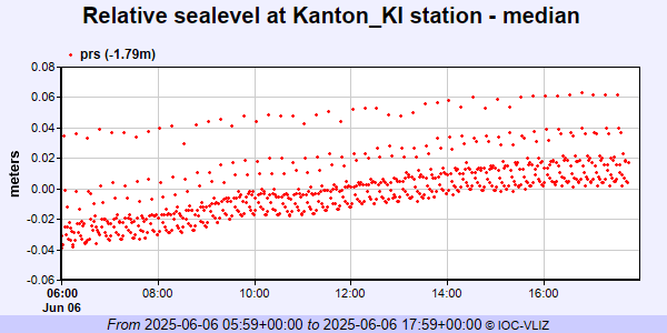 PSMSL Annual Mean Sea Level for '1329' 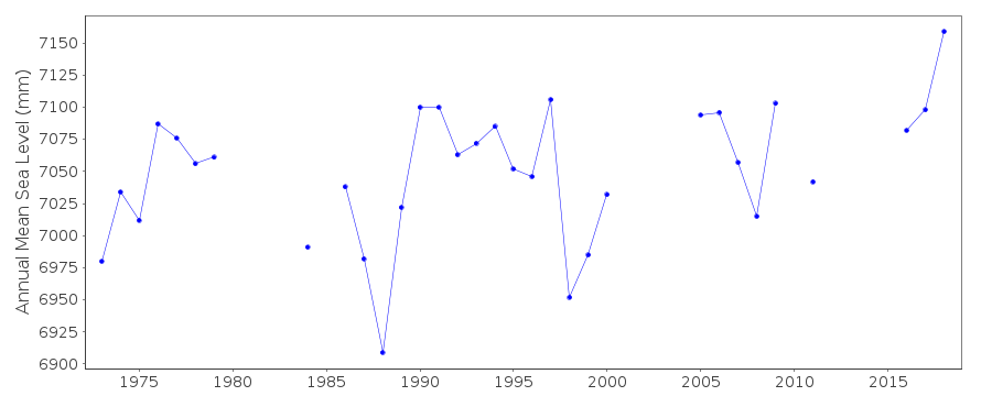 PSMSL Annual Mean Sea Level for '575'  PSMSL Monthly Mean Sea Level for '575' 
|
|
|