 |
SEALEVEL STATION CATALOG (SSC) |
|
|
|
|
|
| Station catalog metadata [edit] | [station overview] |
|---|
| SSC ID | SSC-kanm | | Station Name | Kanmen | | Country | China | | Latitude | 28.08333 | | Longitude | 121.28333 | | DateLastModified | 2015-10-22 19:02:29 |
| Distributed metadata source: GLOSS Station Handbook |
|---|
| Time Zone | 120E, GMT + 8hrs | | Ocean | Pacific | | Operational | Yes | | Data acquisition rate | Recording at hourly intervals | | Additional parameters | Surface T and S, wave and meteorological parameters | | Tide gauge benchmarks | TGBM (ZKZ13) was set up in 1933, about 16.9m from the northeast corner of the gauge well house. | | Benchmark relationships | Tide Gauge Zero (TGZ) = 10.842m below the TGBM (ZKZ13)
TGZ = 3.645m below MSL of the Yellow Sea (1956-old)
TGZ = 3.684m below MSL of the Yellow Sea (1985-new)
TGZ = 3.87m below MSL of Kanmen
| | Auxiliary benchmarks | ZKZ12: 26.2m NE of the tomb and 43.4m NW of the NW corner of Mr. Xu Tongbao's house.
ZKZ12II: 16.6m NW of the NW corner of WC and 9.2m south of 5811# wire pole.
| | Other relevant codes | UHSLC 632 | | Nearest Met. station | Kanmen MS |
| Distributed metadata source: UHSLC |
| UHSLC id | 632 |
| SSC id | kanm |
| GLOSS id | 94 |
| UHSLC geojson | https://uhslc.soest.hawaii.edu/data/meta.geojson |
| Research quality data version a | 1975-01-01 - 1997-12-31 |
| RQ basin | pacific |
| Distributed metadata source: PSMSL |
| Name | KANMEN |
| GLOSS id | 94 |
| UHSLC ID | 632 |
| Is RLR | Y |
| Has RLR Diagram | Y link |
| QC Flag | N |
| Old ID | 610/016 |
| Last Updated | 2025-03-27 |
| Supplier | NATIONAL MARINE DATA AND INFORMATION SERVICE (NMDIS) |
| Address | National Marine Data and Information Service (NMDIS), No. 93 Liuwei Road, Tianjin 300171, CHINA |
| Metric Start | 1959 |
| Metric End | 2024 |
| Metric Completeness | 98.2 |
| RLR Start | 1959 |
| RLR End | 2024 |
| RLR Completeness | 98.2 |
| Download metric sea level data. | Use only with extreme caution. |
PSMSL Annual Mean Sea Level for '934' 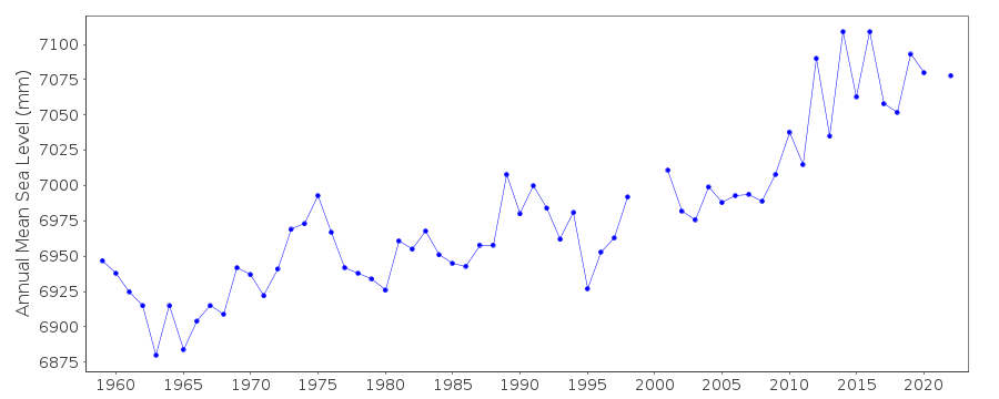 PSMSL Monthly Mean Sea Level for '934' 
|
|
|