 |
SEALEVEL STATION CATALOG (SSC) |
|
|
|
|
|
| Station catalog metadata [edit] | [station overview] |
|---|
| SSC ID | SSC-jolo | | Station Name | Jolo, Sulu | | Country | Philippines | | Latitude | 6.06666 | | Longitude | 121 | | DateLastModified | 2015-10-22 19:02:29 |
| Distributed metadata source: GLOSS Station Handbook |
|---|
| Time Zone | 120E, GMT + 8hrs | | Ocean | Pacific | | Operational | Yes | | Responsible country | Philippines | | Additional parameters | Sea surface temperature, Surface salinity at 15degC | | Tide gauge benchmarks | BM-1 - at Jolo Wharf, Jolo, 8.84m from centreline of roadway leading to city.
BM is a 0.50 calibor cartridge set on top of concrete kerb 20.32cm above ground, 4.57m SW from W corner of steel lighthouse tower.
| | Benchmark relationships | BM-1 was established in 1947 | | Auxiliary benchmarks | BMX, BM1-B, BM1-TH, BM2, BM2A, BM12 | | Other relevant codes | UHSLC 373 | | Nearest Met. station | None |
| Distributed metadata source: UHSLC |
| UHSLC id | 373 |
| SSC id | jolo |
| GLOSS id | 70 |
| UHSLC geojson | https://uhslc.soest.hawaii.edu/data/meta.geojson |
| Research quality data version a | 1984-01-01 - 1995-12-31 |
| RQ basin | pacific |
| Distributed metadata source: PSMSL |
| Name | JOLO, SULU |
| GLOSS id | 70 |
| UHSLC ID | 373 |
| Is RLR | Y |
| Has RLR Diagram | Y link |
| QC Flag | N |
| Old ID | 660/141 |
| Last Updated | 1999-03-30 |
| Supplier | NATIONAL MAPPING AND RESOURCE INFORMATION AUTHORITY |
| Address | National Mapping and Resource Information Authority, Hydrography Department, 421 Barraca St,, San Nicolas 1010, Manila , PHILIPPINES |
| Metric Start | 1924 |
| Metric End | 1996 |
| Metric Completeness | 62.4 |
| RLR Start | 1947 |
| RLR End | 1996 |
| RLR Completeness | 85.0 |
| Download metric sea level data. | Use only with extreme caution. |
PSMSL Annual Mean Sea Level for '260'  PSMSL Monthly Mean Sea Level for '260' 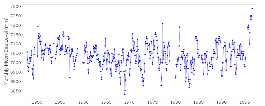
|
|
|