 |
SEALEVEL STATION CATALOG (SSC) |
|
|
|
|
|
| Station catalog metadata [edit] | [station overview] |
|---|
| SSC ID | SSC-john | | Station Name | Johnston Island | | Country | United States | | Latitude | 16.739 | | Longitude | -169.5233 | | DateLastModified | 2015-10-22 19:02:29 |
| Linked codes |
|---|
| Codes | Location | Latitude | Longitude | Sensors | IOC: john | Johnston_US | 16.739 | -169.5233 | prs, rad, enc, bat, sw1, sw2 |
GLOSS: 109 | Johnston Is., Hawaiian Is. | 16.73333 | -169.53333 | Float, Bubbler, Acoustic |
UHSLC: 52 | Johnston | 16.73622 | -169.52826 | N/A |
PTWC: john | Johnston_US | 16.7363 | -169.5283 | prs, rad, enc |
PSMSL: 598 | JOHNSTON ISLAND | 16.738333 | -169.53 | N/A |
SONEL_TG: 2908 | JOHNSTON ISLAND | 16.73629000 | -169.52823100 | N/A |
| Distributed metadata source: IOC Sea Level Station Monitoring Facility john |
|---|
| GTS station code | 15D142A4 |
| GTS message type | SXHW11 |
| Status | Operational |
| Local Contact | University of Hawaii Sea Level Center ( USA ) |
| Connection | GTS message |
| Country | USA |
| Sensor 1 | |
| Type of sensor | prs |
| Sampling rate (min) | 1 |
| Sensor 2 | |
| Type of sensor | rad |
| Sampling rate (min) | 1 |
| Sensor 3 | |
| Type of sensor | enc |
| Sampling rate (min) | 5 |
| Sensor 4 | |
| Type of sensor | sw1 |
| Sampling rate (min) | 60 |
| Sensor 5 | |
| Type of sensor | sw2 |
| Sampling rate (min) | 60 |
| Sensor 6 | |
| Type of sensor | bat |
| Sampling rate (min) | 5 |
| Distributed metadata source: GLOSS Station Handbook |
|---|
| Time Zone | 165W, GMT - 11hrs | | Ocean | Pacific | | Operational | Yes | | Additional parameters | Surface temperature, density | | Tide gauge benchmarks | Benchmark 13(1955) is the primary benchmark (PBM) stamped 'NO 13 1955' set in a concrete bulkhead cap at the inshore end of the small boat pier | | Benchmark relationships | TGBM is 9.35ft above Tide Gauge Zero (Station Datum)
NOAA Chart Datum (MLLW) is 1.74ft above Station Datum
Mean Sea Level (1960-1978) is 2.81ft above Station Datum
| | Auxiliary benchmarks | 10 additional benchmarks are levelled to the TGBM and the Tide Station on a yearly basis (BM 21, BM 28, BM 22, BM 19, BM L, BM 6, BM 12, BM 14, BM MON JOHN, BM NO 1 JOE) | | Other relevant information | NOAA can no longer travel to the gauge | | Other relevant codes | UHSLC 052 |
| Distributed metadata source: PTWC COMP META file |
| DCP ID | 15D142A4 |
| WMO | SXHW11 |
| Samp Rate | 5 |
| Num# Samp | 4 |
| Unit | M |
| Scale | 1.0000 |
| Xmt Int. | 005 |
| Fst Min. | 0002 |
| HAR | 1 |
| Owner | UHSLC |
| Distributed metadata source: UHSLC |
| UHSLC id | 052 |
| SSC id | john2 |
| GLOSS id | 109 |
| UHSLC geojson | https://uhslc.soest.hawaii.edu/data/meta.geojson |
| Research quality data version a | 1947-05-01 - 2024-12-31 |
| RQ basin | pacific |
| Fast delivery | 1947-05-01 - 2026-05-31 |
| Distributed metadata source: PSMSL |
| Name | JOHNSTON ISLAND |
| GLOSS id | 109 |
| UHSLC ID | 52 |
| Is RLR | Y |
| Has RLR Diagram | Y link |
| QC Flag | N |
| Old ID | 760/011 |
| Last Updated | 2020-01-28 |
| Supplier | UNIVERSITY OF HAWAII SEA LEVEL CENTER |
| Address | University of Hawaii Sea Level Center, Department of Oceanography Division of Natural Sciences, 1000 Pope Road, Honolulu, Hawaii 96822, UNITED STATES |
| Metric Start | 1947 |
| Metric End | 2018 |
| Metric Completeness | 90.4 |
| RLR Start | 1947 |
| RLR End | 2018 |
| RLR Completeness | 90.4 |
| Download metric sea level data. | Use only with extreme caution. |
IOC Sea Level Station Monitoring Facility - realtime graph for 'john' 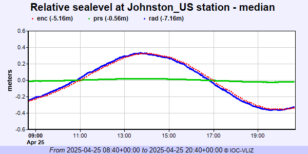 PSMSL Annual Mean Sea Level for '598' 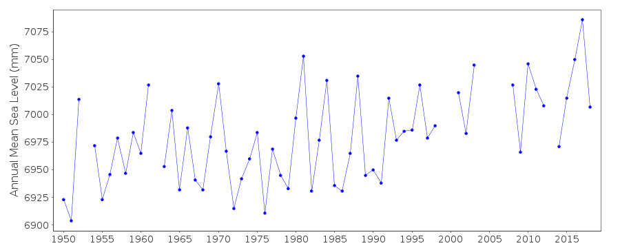 PSMSL Monthly Mean Sea Level for '598' 
|
|
|