 |
SEALEVEL STATION CATALOG (SSC) |
|
|
|
|
|
| Station catalog metadata [edit] | [station overview] |
|---|
| SSC ID | SSC-hilo | | Station Name | Hilo | | Country | United States | | Latitude | 19.733 | | Longitude | -155.058 | | DateLastModified | 2015-10-22 19:02:29 |
| Distributed metadata source: IOC Sea Level Station Monitoring Facility hilo |
|---|
| Status | Operational |
| Local Contact | National Ocean Service-NOAA ( USA ) |
| Connection | WEB service |
| Country | USA |
| Sensor 1 | |
| Type of sensor | wls |
| Sampling rate (min) | 1 |
| Distributed metadata source: IOC Sea Level Station Monitoring Facility hilo2 |
|---|
| GTS station code | 334934A2 |
| GTS message type | SXXX03 |
| Status | Operational |
| Local Contact | National Ocean Service-NOAA ( USA ) |
| Connection | GTS message |
| Country | USA |
| Sensor 1 | |
| Type of sensor | pwl |
| Sampling rate (min) | 1 |
| Distributed metadata source: GLOSS Station Handbook |
|---|
| Time Zone | 150W, GMT - 10hrs | | Ocean | Pacific | | Operational | Yes | | Additional parameters | Surface temperature, density | | Tide gauge benchmarks | Benchmark 4(1951) is the primary benchmark (PBM) stamped 'NO 4 1951' set in top of east corner of northern-most concrete foundation which rests on solid rock for elevated water tank on Port of Hilo property. | | Benchmark relationships | TGBM is 15.30ft above Tide Gauge Zero (Station Datum)
NOAA Chart Datum (MLLW) is 3.69ft above Station Datum
Mean Sea Level (1960-1978) is 4.86ft above Station Datum
| | Auxiliary benchmarks | 10 additional benchmarks are levelled to the TGBM and the Tide Station on a yearly basis (BM E2, BM Pier 3, BM F, BM 5, BM A, BM B, BM C, BM G, BM Lyman, BM Lyman NO 2) | | Other relevant codes | UHSLC 060 |
| Distributed metadata source: PTWC COMP META file |
| DCP ID | 334934A2 |
| WMO | SXXX03 |
| Samp Rate | 6 |
| Num# Samp | 1 |
| Unit | M |
| Scale | 1.0000 |
| Xmt Int. | 006 |
| Fst Min. | 0001 |
| HAR | 1 |
| Owner | NOS |
| Distributed metadata source: UHSLC |
| UHSLC id | 060 |
| SSC id | hilo |
| GLOSS id | 287 |
| UHSLC geojson | https://uhslc.soest.hawaii.edu/data/meta.geojson |
| Research quality data version a | 1927-01-22 - 2021-12-31 |
| RQ basin | pacific |
| Fast delivery | 1927-01-22 - 2026-05-31 |
| Distributed metadata source: PSMSL |
| Name | HILO, HAWAII ISLAND |
| GLOSS id | 287 |
| UHSLC ID | 60 |
| SONEL id | 2982 |
| Is RLR | Y |
| Has RLR Diagram | Y link |
| QC Flag | N |
| Old ID | 760/061 |
| Last Updated | 2026-01-27 |
| Supplier | N.O.A.A. / N.O.S. |
| Address | N.O.A.A. / N.O.S., N/oes33, Ssmc4, Room 6531, 1305 East-West Highway, Silver Spring, , MD 20910, UNITED STATES |
| Metric Start | 1927 |
| Metric End | 2025 |
| Metric Completeness | 84.9 |
| RLR Start | 1927 |
| RLR End | 2025 |
| RLR Completeness | 84.9 |
| Download metric sea level data. | Use only with extreme caution. |
IOC Sea Level Station Monitoring Facility - realtime graph for 'hilo' 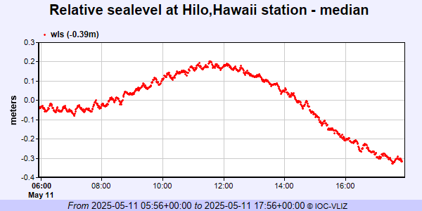 IOC Sea Level Station Monitoring Facility - realtime graph for 'hilo2' 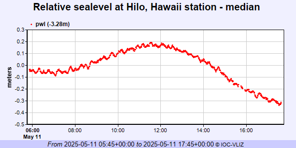 PSMSL Annual Mean Sea Level for '300' 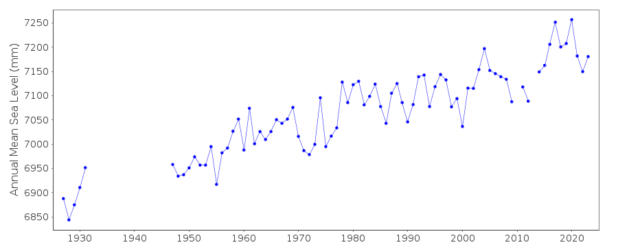 PSMSL Monthly Mean Sea Level for '300' 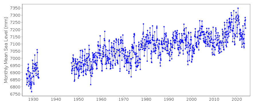
|
|
|