 |
SEALEVEL STATION CATALOG (SSC) |
|
|
|
|
|
| Station catalog metadata [edit] | [station overview] |
|---|
| SSC ID | SSC-harw | | Station Name | Harwich | | Country | United Kingdom | | Latitude | 51.95 | | Longitude | 1.29 | | DateLastModified | 2015-10-22 19:02:29 |
| Linked codes |
|---|
| Codes | Location | Latitude | Longitude | Sensors | IOC: harw | Harwich | 51.95 | 1.29 | bub |
PSMSL: 214 | FELIXSTOWE | 51.957694 | 1.346556 | N/A |
PSMSL: 742 | HARWICH | 51.948 | 1.292139 | N/A |
| Distributed metadata source: IOC Sea Level Station Monitoring Facility harw |
|---|
| Status | Operational |
| Local Contact | National Oceanography Centre ( UK ) |
| Connection | FTP box |
| Country | UK |
| Sensor 1 | |
| Type of sensor | bub |
| Sampling rate (min) | 15 |
| Distributed metadata source: PSMSL |
| Name | FELIXSTOWE |
| Is RLR | Y |
| Has RLR Diagram | Y link |
| QC Flag | Y |
| Old ID | 170/071 |
| Last Updated | 2026-02-19 |
| Supplier | ENVIRONMENT AGENCY |
| Address | Environment Agency, Horizon House, Deanery Road, BS1 5AH, Bristol, UNITED KINGDOM |
| Metric Start | 1917 |
| Metric End | 2011 |
| Metric Completeness | 60.9 |
| RLR Start | 1980 |
| RLR End | 2011 |
| RLR Completeness | 82.3 |
| Download metric sea level data. | Use only with extreme caution. |
| Name | HARWICH |
| Is RLR | Y |
| Has RLR Diagram | Y link |
| QC Flag | N |
| Old ID | 170/073 |
| Last Updated | 2026-02-19 |
| Supplier | ENVIRONMENT AGENCY |
| Address | Environment Agency, Horizon House, Deanery Road, BS1 5AH, Bristol, UNITED KINGDOM |
| Metric Start | 1954 |
| Metric End | 2025 |
| Metric Completeness | 52.3 |
| RLR Start | 1960 |
| RLR End | 1974 |
| RLR Completeness | 92.2 |
| Download metric sea level data. | Use only with extreme caution. |
IOC Sea Level Station Monitoring Facility - realtime graph for 'harw' 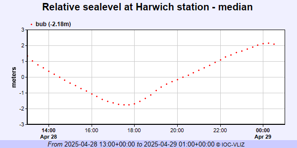 PSMSL Annual Mean Sea Level for '214' 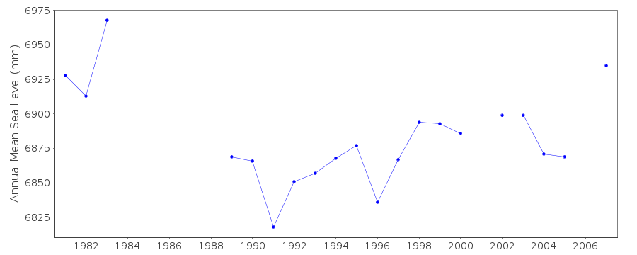 PSMSL Annual Mean Sea Level for '742' 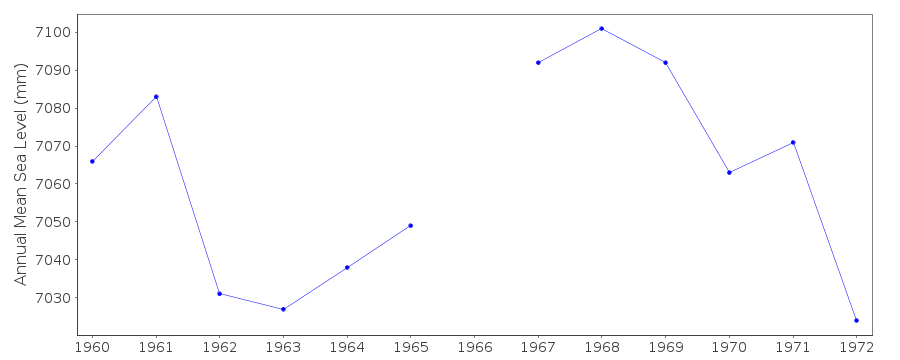 PSMSL Monthly Mean Sea Level for '742' 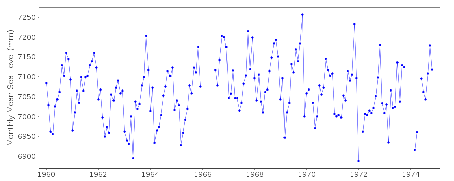
|
|
|