 |
SEALEVEL STATION CATALOG (SSC) |
|
|
|
|
|
| Station catalog metadata [edit] | [station overview] |
|---|
| SSC ID | SSC-guam | | Station Name | Guam | | Country | United States | | Latitude | 13.438 | | Longitude | 144.652 | | DateLastModified | 2025-05-08 22:03:27 |
| Distributed metadata source: IOC Sea Level Station Monitoring Facility guam |
|---|
| Status | Operational |
| Local Contact | National Ocean Service-NOAA ( USA ) |
| Connection | WEB service |
| Country | USA |
| Sensor 1 | |
| Type of sensor | wls |
| Sampling rate (min) | 6 |
| Distributed metadata source: IOC Sea Level Station Monitoring Facility guam2 |
|---|
| GTS station code | APRP7 |
| GTS message type | SZPA37 |
| Status | Operational |
| Local Contact | National Ocean Service-NOAA ( USA ) |
| Connection | GTS message |
| Country | USA |
| Sensor 1 | |
| Type of sensor | pwl |
| Sampling rate (min) | 1 |
| Distributed metadata source: GLOSS Station Handbook |
|---|
| Time Zone | 150E, GMT + 10hrs | | Ocean | Pacific | | Operational | Yes | | Additional parameters | Air temperature, barometric pressure, wind sensors | | Tide gauge benchmarks | Benchmark 4 (1949) is the primary benchmark (PBM) stamped 'NO 4 1949' set in the northwest side of a 6ft by 12ft concrete manhole in the centre of the road. | | Benchmark relationships | TGBM is 9.83ft above Tide Gauge Zero (Station Datum)
NOAA Chart Datum (MLLW) is 1.24ft above Station Datum
Mean Sea Level (1960-1978) is 2.65ft above Station Datum
| | Auxiliary benchmarks | 9 additional benchmarks are levelled to the TGBM and the Tide Station on a yearly basis.
BM's L, 5, and USN BM1 subsided during earthquake - October 1993 site inspection was primarily for levelling due to recent earthquake.
Other benchmarks include: BM 11, BM 4, BM 12, BM 13, BM 7 (P.I.E.), BM K, BM 6, BM 13
| | Other relevant codes | UHSLC 053 |
| Distributed metadata source: PTWC COMP META file |
| DCP ID | APRP7 |
| WMO | SZPA37 |
| Samp Rate | 1 |
| Num# Samp | 6 |
| Unit | M |
| Scale | 1.0000 |
| Xmt Int. | 006 |
| Fst Min. | 0000 |
| HAR | 1 |
| Owner | NOS |
| Distributed metadata source: UHSLC |
| UHSLC id | 053 |
| SSC id | guam |
| GLOSS id | 149 |
| UHSLC geojson | https://uhslc.soest.hawaii.edu/data/meta.geojson |
| Research quality data version a | 1948-03-10 - 2021-12-31 |
| RQ basin | pacific |
| Fast delivery | 1948-03-10 - 2026-05-31 |
| Distributed metadata source: PSMSL |
| Name | APRA HARBOR |
| GLOSS id | 149 |
| UHSLC ID | 53 |
| SONEL id | 4201 |
| Is RLR | Y |
| Has RLR Diagram | Y link |
| QC Flag | N |
| Old ID | 701/001 |
| Last Updated | 2026-01-28 |
| Supplier | N.O.A.A. / N.O.S. |
| Address | N.O.A.A. / N.O.S., N/oes33, Ssmc4, Room 6531, 1305 East-West Highway, Silver Spring, , MD 20910, UNITED STATES |
| Metric Start | 1948 |
| Metric End | 2025 |
| Metric Completeness | 94.8 |
| RLR Start | 1948 |
| RLR End | 2025 |
| RLR Completeness | 94.8 |
| Download metric sea level data. | Use only with extreme caution. |
IOC Sea Level Station Monitoring Facility - realtime graph for 'guam' 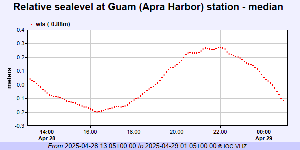 IOC Sea Level Station Monitoring Facility - realtime graph for 'guam2' 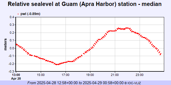 PSMSL Annual Mean Sea Level for '540' 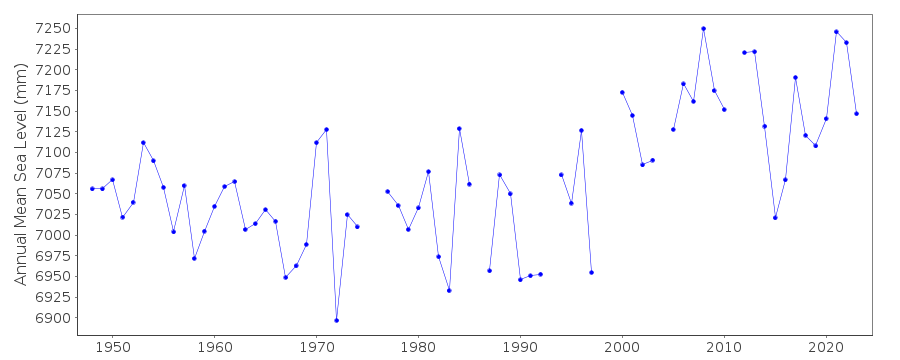 PSMSL Monthly Mean Sea Level for '540' 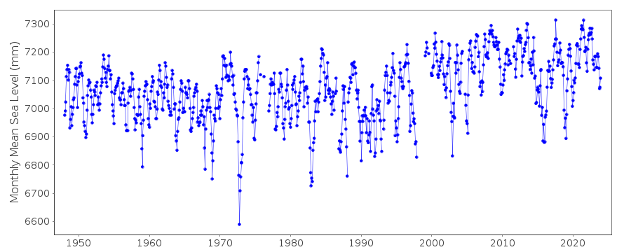
|
|
|