 |
SEALEVEL STATION CATALOG (SSC) |
|
|
|
|
|
| Station catalog metadata [edit] | [station overview] |
|---|
| SSC ID | SSC-gptx | | Station Name | Galveston Pier | | Country | United States | | Latitude | 29.31 | | Longitude | -94.793 | | DateLastModified | 2015-10-22 19:02:29 |
| Linked codes |
|---|
| Codes | Location | Latitude | Longitude | Sensors | IOC: gptx | Galveston_Pier_TX | 29.31 | -94.793 | bwl |
IOC: gptx2 | Galveston_Pier_TX | 29.31 | -94.793 | pwl |
GLOSS: 217 | Galveston (Pier 21), TX | 29.31666 | -94.8 | Float, Pressure, Bubbler, Acoustic |
UHSLC: 767 | Galveston, Pleasure Pier | 29.2867 | -94.79 | N/A |
UHSLC: 775 | Galveston, Pier 21 | 29.31 | -94.7933 | N/A |
PTWC: gptx | Galveston_Pier_TX | 29.3100 | -94.7933 | pwc, pwl, bwl |
PTWC: pptx | | | | |
PSMSL: 161 | GALVESTON II, PIER 21, TX | 29.31 | -94.793333 | N/A |
PSMSL: 828 | GALVESTON I, PLEASURE PIER, TX | 29.285 | -94.788333 | N/A |
SONEL_GPS: 1934 | GALVESTON | 29.28515600 | -94.78924600 | N/A |
SONEL_GPS: 2973 | GALVESTON | 29.32786700 | -94.77263600 | N/A |
SONEL_GPS: 676 | GALVESTON | 29.32988068 | -94.73680897 | N/A |
SONEL_TG: 2355 | GALVESTON | 29.30974700 | -94.79346800 | N/A |
SONEL_TG: 2356 | GALVESTON | 29.28515600 | -94.78924600 | N/A |
| Distributed metadata source: IOC Sea Level Station Monitoring Facility gptx |
|---|
| GTS station code | 336AB456 |
| GTS message type | SXTX03 |
| Status | Operational |
| Local Contact | National Ocean Service-NOAA ( USA ) |
| Connection | WEB service |
| Country | USA |
| Sensor 1 | |
| Type of sensor | bwl |
| Sampling rate (min) | 1 |
| Distributed metadata source: IOC Sea Level Station Monitoring Facility gptx2 |
|---|
| GTS station code | 336AB456 |
| GTS message type | SXTX03 |
| Status | Incorrect data |
| Local Contact | National Ocean Service-NOAA ( USA ) |
| Connection | GTS message |
| Country | USA |
| Sensor 1 | |
| Type of sensor | pwl |
| Sampling rate (min) | 1 |
| Distributed metadata source: GLOSS Station Handbook |
|---|
| Time Zone | 090W, GMT - 6hrs | | Ocean | Atlantic | | Operational | Yes | | Data acquisition rate | 6 minute intervals | | Additional parameters | Surface temperature and density | | Tide gauge benchmarks | US Army Corps of Engineers survey disk stamped '7.151' set in the sidewalk near the northeast corner of the Hendley Building on 20th Street, Galveston, TX. | | Benchmark relationships | TGBM is 10.183 feet above tide staff zero
TGBM = 5.63 feet above mean lower low water (1960-1978 epoch)
TGBM = 4.81 feet above mean sea level (1960-1978 epoch)
TGBM = 4.31 feet above mean high water (1960-1978 epoch)
| | Auxiliary benchmarks | USC & GS 32 1913
No stamping 1 = 13.362ft
USC & GS J305 1935
USED 19 bolt
USC & GS 40 1935 reset
1450A 1989 = 11.058ft
USC & GS 41 1935 reset
Aquatrak Levelling Point = 20.147ft
USC & GS 42 1943 = 9.981ft
NOS NO 2 1974 = 9.979ft
Heights are in feet above staff zero
| | Other relevant information | Nearby station located at Galveston Pleasure Pier (outside on the Gulf of Mexico) has shorter and less continuous record length than Galveston Pier 21 (inside) station described above (PSMSL Code 940/007; PSMSL hold data 1957-1973, 1978-1990). | | Other relevant codes | UHSLC 775 |
| Distributed metadata source: PTWC COMP META file |
| DCP ID | 335EA46A |
| WMO | SXTX03 |
| Samp Rate | 6 |
| Num# Samp | 1 |
| Unit | M |
| Scale | 1.0000 |
| Xmt Int. | 006 |
| Fst Min. | 0002 |
| HAR | 0 |
| Owner | NOS |
| Distributed metadata source: UHSLC |
| UHSLC id | 767 |
| SSC id | gapp |
| UHSLC geojson | https://uhslc.soest.hawaii.edu/data/meta.geojson |
| Research quality data version a | 1957-08-21 - 2011-07-20 |
| RQ basin | atlantic |
| Fast delivery | 1957-08-21 - 2011-07-20 |
| UHSLC id | 775 |
| SSC id | galv |
| GLOSS id | 217 |
| UHSLC geojson | https://uhslc.soest.hawaii.edu/data/meta.geojson |
| Research quality data version a | 1904-01-01 - 2021-12-31 |
| RQ basin | atlantic |
| Fast delivery | 1904-01-01 - 2026-05-31 |
| Distributed metadata source: PSMSL |
| Name | GALVESTON II, PIER 21, TX |
| GLOSS id | 217 |
| UHSLC ID | 775 |
| SONEL id | 2973 |
| Is RLR | Y |
| Has RLR Diagram | Y link |
| QC Flag | N |
| Old ID | 940/008 |
| Last Updated | 2026-01-27 |
| Supplier | N.O.A.A. / N.O.S. |
| Address | N.O.A.A. / N.O.S., N/oes33, Ssmc4, Room 6531, 1305 East-West Highway, Silver Spring, , MD 20910, UNITED STATES |
| Metric Start | 1908 |
| Metric End | 2025 |
| Metric Completeness | 99.2 |
| RLR Start | 1908 |
| RLR End | 2025 |
| RLR Completeness | 99.2 |
| Download metric sea level data. | Use only with extreme caution. |
| Name | GALVESTON I, PLEASURE PIER, TX |
| GLOSS id | 217 |
| UHSLC ID | 775 |
| SONEL id | 2973 |
| Is RLR | Y |
| Has RLR Diagram | Y link |
| QC Flag | N |
| Old ID | 940/007 |
| Last Updated | 2012-03-07 |
| Supplier | N.O.A.A. / N.O.S. |
| Address | N.O.A.A. / N.O.S., N/oes33, Ssmc4, Room 6531, 1305 East-West Highway, Silver Spring, , MD 20910, UNITED STATES |
| Metric Start | 1957 |
| Metric End | 2011 |
| Metric Completeness | 89.4 |
| RLR Start | 1957 |
| RLR End | 2011 |
| RLR Completeness | 89.4 |
| Download metric sea level data. | Use only with extreme caution. |
IOC Sea Level Station Monitoring Facility - realtime graph for 'gptx' 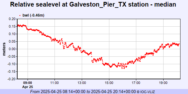 IOC Sea Level Station Monitoring Facility - realtime graph for 'gptx2'  PSMSL Annual Mean Sea Level for '161'  PSMSL Annual Mean Sea Level for '828' 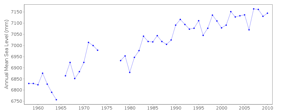 PSMSL Monthly Mean Sea Level for '828' 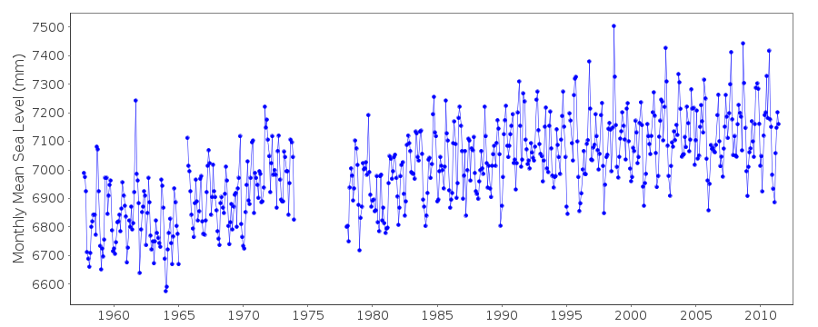
|
|
|