 |
SEALEVEL STATION CATALOG (SSC) |
|
|
|
|
|
| Station catalog metadata [edit] | [station overview] |
|---|
| SSC ID | SSC-ganm | | Station Name | Gan | | Country | Maldives | | Latitude | -0.6867 | | Longitude | 73.1517 | | DateLastModified | 2015-10-22 19:02:29 |
| Distributed metadata source: IOC Sea Level Station Monitoring Facility ganm |
|---|
| GTS station code | 300434064634660 |
| GTS message type | SZXX01 |
| Status | Operational |
| Local Contact | Maldives Meteorological Department ( Maldives ) |
| Other Contact | University of Hawaii Sea Level Center ( USA ) |
| Connection | GTS message |
| Country | Maldive Islands |
| Sensor 1 | |
| Type of sensor | prs |
| Sampling rate (min) | 1 |
| Sensor 2 | |
| Type of sensor | rad |
| Sampling rate (min) | 1 |
| Sensor 3 | |
| Type of sensor | ra2 |
| Sampling rate (min) | 1 |
| Sensor 4 | |
| Type of sensor | bat |
| Sampling rate (min) | 5 |
| Sensor 5 | |
| Type of sensor | ra3 |
| Sampling rate (min) | 1 |
| Sensor 6 | |
| Type of sensor | ras |
| Sampling rate (min) | 1 |
| Distributed metadata source: GLOSS Station Handbook |
|---|
| Time Zone | 075E, GMT + 5hrs | | Ocean | Indian | | Operational | Yes | | Data acquisition rate | Hourly intervals | | Other relevant information | Daily values calculated using 119-point convolution filter (Bloomfield, 1976) centred on noon applied to the hourly data with respective periods of the 95, 50 and 5% amplitude points at 124.0, 60.2 and 40.2 hours.
PSMSL hold data from another gauge at Gan (PSMSL Code 454/001 1962-1963)
| | Other relevant codes | UHSLC 109 |
| Distributed metadata source: PTWC COMP META file |
| DCP ID | 300434064634660 |
| WMO | SZXX01 |
| Samp Rate | 1 |
| Num# Samp | 5 |
| Unit | M |
| Scale | 1.0000 |
| Xmt Int. | 005 |
| Fst Min. | 0001 |
| HAR | 1 |
| Owner | UHSLC |
| Distributed metadata source: UHSLC |
| UHSLC id | 109 |
| SSC id | ganm |
| GLOSS id | 27 |
| UHSLC geojson | https://uhslc.soest.hawaii.edu/data/meta.geojson |
| Research quality data version a | 1987-03-04 - 2024-12-31 |
| RQ basin | indian |
| Fast delivery | 1987-03-04 - 2026-05-31 |
| Distributed metadata source: PSMSL |
| Name | GAN I |
| GLOSS id | 27 |
| Is RLR | N |
| Has RLR Diagram | N link |
| QC Flag | N |
| Old ID | 454/001 |
| Last Updated | null |
| Supplier | UNITED KINGDOM HYDROGRAPHIC OFFICE |
| Address | United Kingdom Hydrographic Office, Admiralty Way, Taunton, Somerset , TA1 2DN, UNITED KINGDOM |
| Metric Start | 1962 |
| Metric End | 1963 |
| Metric Completeness | 50.0 |
| Download metric sea level data. | Use only with extreme caution. |
| Name | GAN II |
| GLOSS id | 27 |
| UHSLC ID | 109 |
| SONEL id | 3412 |
| Is RLR | Y |
| Has RLR Diagram | Y link |
| QC Flag | N |
| Old ID | 454/002 |
| Last Updated | 2020-01-29 |
| Supplier | UNIVERSITY OF HAWAII SEA LEVEL CENTER |
| Address | University of Hawaii Sea Level Center, Department of Oceanography Division of Natural Sciences, 1000 Pope Road, Honolulu, Hawaii 96822, UNITED STATES |
| Metric Start | 1987 |
| Metric End | 2018 |
| Metric Completeness | 93.8 |
| RLR Start | 1987 |
| RLR End | 2018 |
| RLR Completeness | 93.8 |
| Download metric sea level data. | Use only with extreme caution. |
IOC Sea Level Station Monitoring Facility - realtime graph for 'ganm' 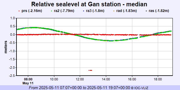 PSMSL Annual Mean Sea Level for '1025'  PSMSL Annual Mean Sea Level for '1707' 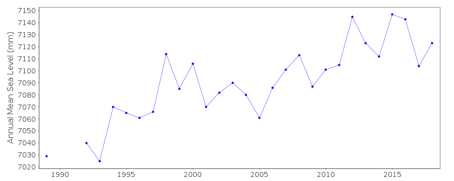 PSMSL Monthly Mean Sea Level for '1707' 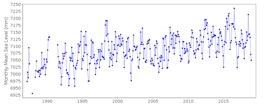
|
|
|