 |
SEALEVEL STATION CATALOG (SSC) |
|
|
|
|
|
| Station catalog metadata [edit] | [station overview] |
|---|
| SSC ID | SSC-galw | | Station Name | Galway | | Country | Ireland | | Latitude | 53.266667 | | Longitude | -9.033333 | | DateLastModified | 2015-10-22 19:02:29 |
| Linked codes |
|---|
| Codes | Location | Latitude | Longitude | Sensors | PSMSL: 1083 | GALWAY | 53.266667 | -9.033333 | N/A |
PSMSL: 2474 | GALWAY PORT | 53.268955 | -9.047991999999999 | N/A |
| Distributed metadata source: PSMSL |
| Name | GALWAY |
| Is RLR | N |
| Has RLR Diagram | N link |
| QC Flag | N |
| Old ID | 175/031 |
| Last Updated | 1992-05-14 |
| Supplier | N.O.C. |
| Address | British Oceanographic Data Centre, National Oceanography Centre, Joseph Proudman Building, 6 Brownlow Street, Liverpool, L3 5DA, UNITED KINGDOM |
| Metric Start | 1964 |
| Metric End | 1970 |
| Metric Completeness | 69.0 |
| Download metric sea level data. | Use only with extreme caution. |
| Name | GALWAY PORT |
| Is RLR | Y |
| Has RLR Diagram | Y link |
| QC Flag | N |
| Last Updated | 2025-11-13 |
| Supplier | MARINE INSTITUTE |
| Address | Ocean Sciences and Information Services, Marine Institute, Rinville West, Oranmore, Co. Galway H91 R673, IRELAND |
| Metric Start | 2007 |
| Metric End | 2025 |
| Metric Completeness | 93.0 |
| RLR Start | 2007 |
| RLR End | 2025 |
| RLR Completeness | 93.0 |
| Download metric sea level data. | Use only with extreme caution. |
PSMSL Annual Mean Sea Level for '1083'  PSMSL Annual Mean Sea Level for '2474' 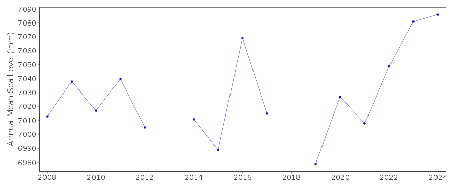 PSMSL Monthly Mean Sea Level for '2474' 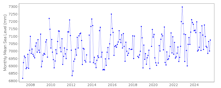
|
|
|