 |
SEALEVEL STATION CATALOG (SSC) |
|
|
|
|
|
| Station catalog metadata [edit] | [station overview] |
|---|
| SSC ID | SSC-fren | | Station Name | Tern, French Frigate Shoals | | Country | United States | | Latitude | 23.867 | | Longitude | -166.283 | | DateLastModified | 2015-10-22 19:02:29 |
| Linked codes |
|---|
| Codes | Location | Latitude | Longitude | Sensors | IOC: fren | Tern,Fr._Frigate_US | 23.867 | -166.283 | prs, rad, ra2, ra3, sw1, sw2, bat |
GLOSS: 107 | French Frigate Shoals, H | 23.86666 | -166.28333 | Float, Pressure |
UHSLC: 14 | French Frigate Shoals | 23.86781 | -166.28898 | N/A |
PTWC: fren | Tern_Fr._Frigate_US | 23.8670 | -166.2830 | prs, ra2, ra3, rad |
PSMSL: 1372 | FRENCH FRIGATE SHOALS | 23.866667 | -166.283333 | N/A |
PSMSL: 2192 | FRENCH FRIGATE SHOALS B | 23.868333 | -166.288333 | N/A |
SONEL_TG: 2840 | TERN ISLAND | 23.86886700 | -166.28836200 | N/A |
| Distributed metadata source: IOC Sea Level Station Monitoring Facility fren |
|---|
| GTS station code | 301434061606460 |
| GTS message type | SZXX01 |
| Status | Operational |
| Local Contact | University of Hawaii Sea Level Center ( USA ) |
| Other Contact | Pacific Tsunami Warning Center ( USA ) |
| Connection | GTS message |
| Country | USA |
| Sensor 1 | |
| Type of sensor | prs |
| Sampling rate (min) | 1 |
| Sensor 2 | |
| Type of sensor | rad |
| Sampling rate (min) | 1 |
| Sensor 3 | |
| Type of sensor | ra2 |
| Sampling rate (min) | 1 |
| Sensor 4 | |
| Type of sensor | ra3 |
| Sampling rate (min) | 1 |
| Sensor 5 | |
| Type of sensor | bat |
| Sampling rate (min) | 5 |
| Sensor 6 | |
| Type of sensor | sw1 |
| Sampling rate (min) | 60 |
| Sensor 7 | |
| Type of sensor | sw2 |
| Sampling rate (min) | 60 |
| Distributed metadata source: GLOSS Station Handbook |
|---|
| Time Zone | 165W, GMT - 11hrs | | Ocean | Pacific | | Operational | Yes | | Auxiliary benchmarks | UH2 SS bolt head, set in concrete, at entrance of tide house.
UH3 SS bolt set in concrete, stamped 'KAMBIC/ JONES' on sea wall 2ft west of tide well.
UH4 SS bolt head set in concrete, stamped '4', located at the north west corner of the Weather Service tower.
UH5 SS bolt head set in concrete, NW corner steps of Main building.
| | Other relevant information | Other benchmark: UH6 SS bolt head set in concrete, no stamp, located at the NE corner of the Main building foundation pillar.
Daily values calculated using 119-point convolution filter (Bloomfield, 1976) centred on noon applied to the hourly data with respective periods of the 95, 50 and 5% amplitude points at 124.0, 60.2 and 40.2 hours.
| | Other relevant codes | UHSLC 014 |
| Distributed metadata source: PTWC COMP META file |
| DCP ID | 301434061606460 |
| WMO | SZXX01 |
| Samp Rate | 1 |
| Num# Samp | 5 |
| Unit | M |
| Scale | 1.0000 |
| Xmt Int. | 005 |
| Fst Min. | 0001 |
| HAR | 1 |
| Owner | UHSLC |
| Distributed metadata source: UHSLC |
| UHSLC id | 014 |
| SSC id | fren |
| GLOSS id | 107 |
| UHSLC geojson | https://uhslc.soest.hawaii.edu/data/meta.geojson |
| Research quality data version a | 1974-07-03 - 2007-03-06 |
| Research quality data version b | 2007-05-26 - 2012-12-24 |
| Research quality data version c | 2013-03-23 - 2018-10-04 |
| Research quality data version d | 2019-05-19 - 2024-12-31 |
| RQ basin | pacific |
| Fast delivery | 2019-05-20 - 2026-06-30 |
| Distributed metadata source: PSMSL |
| Name | FRENCH FRIGATE SHOALS |
| GLOSS id | 107 |
| UHSLC ID | 14 |
| SONEL id | 4333 |
| Is RLR | Y |
| Has RLR Diagram | Y link |
| QC Flag | N |
| Old ID | 760/016 |
| Last Updated | 2013-10-14 |
| Supplier | UNIVERSITY OF HAWAII SEA LEVEL CENTER |
| Address | University of Hawaii Sea Level Center, Department of Oceanography Division of Natural Sciences, 1000 Pope Road, Honolulu, Hawaii 96822, UNITED STATES |
| Metric Start | 1974 |
| Metric End | 2006 |
| Metric Completeness | 94.4 |
| RLR Start | 1974 |
| RLR End | 2006 |
| RLR Completeness | 94.4 |
| Download metric sea level data. | Use only with extreme caution. |
| Name | FRENCH FRIGATE SHOALS B |
| GLOSS id | 107 |
| UHSLC ID | 14 |
| SONEL id | 4333 |
| Is RLR | Y |
| Has RLR Diagram | Y link |
| QC Flag | N |
| Old ID | 760/017 |
| Last Updated | 2020-01-29 |
| Supplier | UNIVERSITY OF HAWAII SEA LEVEL CENTER |
| Address | University of Hawaii Sea Level Center, Department of Oceanography Division of Natural Sciences, 1000 Pope Road, Honolulu, Hawaii 96822, UNITED STATES |
| Metric Start | 2007 |
| Metric End | 2018 |
| Metric Completeness | 70.1 |
| RLR Start | 2007 |
| RLR End | 2018 |
| RLR Completeness | 70.1 |
| Download metric sea level data. | Use only with extreme caution. |
IOC Sea Level Station Monitoring Facility - realtime graph for 'fren' 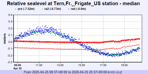 PSMSL Annual Mean Sea Level for '1372' 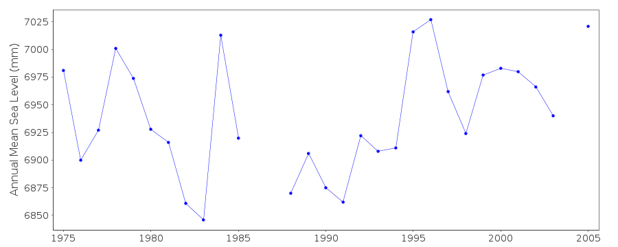 PSMSL Annual Mean Sea Level for '2192' 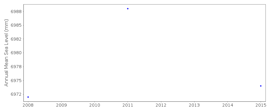 PSMSL Monthly Mean Sea Level for '2192' 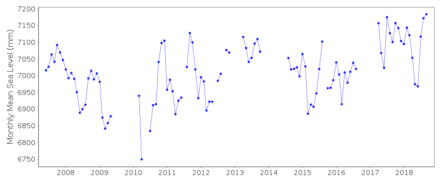
|
|
|