 |
SEALEVEL STATION CATALOG (SSC) |
|
|
|
|
|
| Station catalog metadata [edit] | [station overview] |
|---|
| SSC ID | SSC-fpnt | | Station Name | San Francisco | | Country | United States | | Latitude | 37.807 | | Longitude | -122.465 | | DateLastModified | 2015-10-22 19:02:29 |
| Distributed metadata source: IOC Sea Level Station Monitoring Facility fpnt |
|---|
| GTS station code | 336172E0 |
| GTS message type | SXXX03 |
| Status | Operational |
| Local Contact | National Ocean Service-NOAA ( USA ) |
| Connection | WEB service |
| Country | USA |
| Sensor 1 | |
| Type of sensor | wls |
| Sampling rate (min) | 1 |
| Distributed metadata source: IOC Sea Level Station Monitoring Facility fpnt2 |
|---|
| GTS station code | 336172E0 |
| GTS message type | SXXX03 |
| Status | Operational |
| Local Contact | National Ocean Service-NOAA ( USA ) |
| Connection | GTS message |
| Country | USA |
| Sensor 1 | |
| Type of sensor | pwl |
| Sampling rate (min) | 1 |
| Distributed metadata source: GLOSS Station Handbook |
|---|
| Time Zone | 120W, GMT - 8hrs | | Ocean | Pacific | | Operational | Yes | | Data acquisition rate | 6 minute intervals | | Additional parameters | Sea surface temperature, density | | Tide gauge benchmarks | US C&GS tidal benchmark survey disk stamped '180 1936' set in a concrete wall at the Fort Point Coastguard Station. | | Benchmark relationships | TGBM = 13.24 feet above mean lower low water (1960-1978 epoch)
TGBM = 10.11 feet above mean sea level (1960-1978 epoch)
TGBM = 8.01 feet above mean high water (1960-1978 epoch)
| | Auxiliary benchmarks | 174 1925 4290 J 1976
175 1925 4290 K 1976
176 1925 4290 L 1976
181 1945 4290 M 1982
NO 2 1948 CLARK 1948
| | Other relevant codes | UHSLC 551 |
| Distributed metadata source: PTWC COMP META file |
| DCP ID | 336172E0 |
| WMO | SXXX03 |
| Samp Rate | 6 |
| Num# Samp | 1 |
| Unit | M |
| Scale | 1.3662 |
| Xmt Int. | 006 |
| Fst Min. | 0002 |
| HAR | 1 |
| Owner | NOS |
| Distributed metadata source: UHSLC |
| UHSLC id | 551 |
| SSC id | fpnt |
| GLOSS id | 158 |
| UHSLC geojson | https://uhslc.soest.hawaii.edu/data/meta.geojson |
| Research quality data version a | 1897-08-01 - 2021-12-31 |
| RQ basin | pacific |
| Fast delivery | 1897-08-01 - 2026-05-31 |
| Distributed metadata source: PSMSL |
| Name | SAN FRANCISCO |
| GLOSS id | 158 |
| UHSLC ID | 551 |
| SONEL id | 3094 |
| Is RLR | Y |
| Has RLR Diagram | Y link |
| QC Flag | N |
| Old ID | 823/031 |
| Last Updated | 2026-01-27 |
| Supplier | N.O.A.A. / N.O.S. |
| Address | N.O.A.A. / N.O.S., N/oes33, Ssmc4, Room 6531, 1305 East-West Highway, Silver Spring, , MD 20910, UNITED STATES |
| Metric Start | 1854 |
| Metric End | 2025 |
| Metric Completeness | 99.3 |
| RLR Start | 1854 |
| RLR End | 2025 |
| RLR Completeness | 99.3 |
| Download metric sea level data. | Use only with extreme caution. |
IOC Sea Level Station Monitoring Facility - realtime graph for 'fpnt' 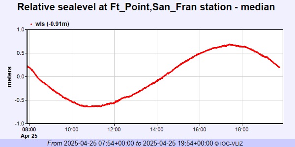 IOC Sea Level Station Monitoring Facility - realtime graph for 'fpnt2' 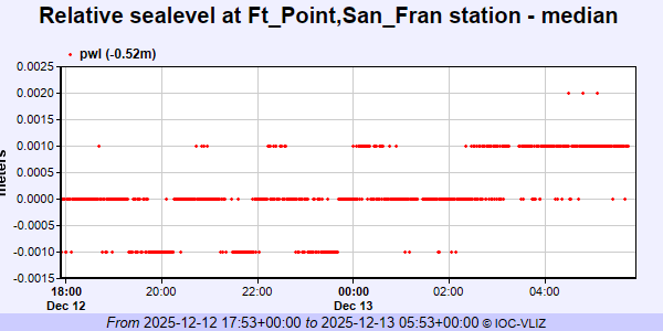 PSMSL Annual Mean Sea Level for '10'  PSMSL Monthly Mean Sea Level for '10' 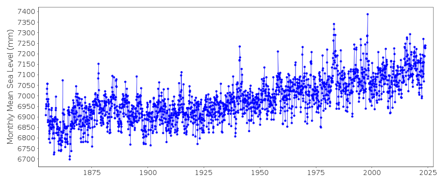
|
|
|