 |
SEALEVEL STATION CATALOG (SSC) |
|
|
|
|
|
| Station catalog metadata [edit] | [station overview] |
|---|
| SSC ID | SSC-fpga | | Station Name | Fort Pulaski | | Country | United States | | Latitude | 32.033 | | Longitude | -80.902 | | DateLastModified | 2015-10-22 19:02:29 |
| Linked codes |
|---|
| Codes | Location | Latitude | Longitude | Sensors | IOC: fpga | Fort_Pulaski_GA | 32.033 | -80.902 | wls |
IOC: fpga2 | Fort_Pulaski_GA | 32.033 | -80.902 | pwl |
GLOSS: 289 | Fort Pulaski, GA | 32.03333 | -80.9 | Float, Bubbler, Acoustic |
UHSLC: 752 | Fort Pulaski | 32.0333 | -80.9017 | N/A |
PTWC: fpga | Fort_Pulaski_GA | 32.0367 | -80.9017 | pwc, pwl, bwl |
PSMSL: 395 | FORT PULASKI | 32.033333 | -80.901667 | N/A |
SONEL_GPS: 2721 | FORT PULASKI | 31.98757700 | -81.02290100 | N/A |
SONEL_TG: 2720 | FORT PULASKI | 32.03466000 | -80.90303200 | N/A |
| Distributed metadata source: IOC Sea Level Station Monitoring Facility fpga |
|---|
| GTS station code | 335F151E |
| GTS message type | SXXX03 |
| Status | Operational |
| Local Contact | National Ocean Service-NOAA ( USA ) |
| Connection | WEB service |
| Country | USA |
| Sensor 1 | |
| Type of sensor | wls |
| Sampling rate (min) | 1 |
| Distributed metadata source: IOC Sea Level Station Monitoring Facility fpga2 |
|---|
| GTS station code | 335F151E |
| GTS message type | SXXX03 |
| Status | Operational |
| Local Contact | National Ocean Service-NOAA ( USA ) |
| Connection | GTS message |
| Country | USA |
| Sensor 1 | |
| Type of sensor | pwl |
| Sampling rate (min) | 1 |
| Distributed metadata source: GLOSS Station Handbook |
|---|
| Time Zone | 075W, GMT - 5hrs | | Ocean | Atlantic | | Operational | Yes | | Data acquisition rate | 6 minute intervals | | Additional parameters | Daily sea surface temperature and density | | Tide gauge benchmarks | US C&GS benchmark survey disk stamped '5' set on a concrete post located south of the concrete parking lot for the Savannah Bar Pilot's Residence. | | Benchmark relationships | TGBM = 12.75 feet above mean lower low water (1960-1978 epoch)
TGBM = 8.95 feet above mean sea level (1960-1978 epoch)
TGBM = 5.65 feet above mean high water (1960-1978 epoch)
| | Auxiliary benchmarks | 7'
0970 J 1977
11 1944
0870 K 1977
NO 1 1949
0870 L 1978
NO 2 1949
N323 1974
N323 1974
1993 inspection states: 'all benchmarks were recovered per NOS descriptions'
| | Other relevant codes | UHSLC 752 |
| Distributed metadata source: PTWC COMP META file |
| DCP ID | 335F151E |
| WMO | SXXX03 |
| Samp Rate | 6 |
| Num# Samp | 1 |
| Unit | M |
| Scale | 1.3805 |
| Xmt Int. | 006 |
| Fst Min. | 0002 |
| HAR | 1 |
| Owner | NOS |
| Distributed metadata source: UHSLC |
| UHSLC id | 752 |
| SSC id | forp |
| GLOSS id | 289 |
| UHSLC geojson | https://uhslc.soest.hawaii.edu/data/meta.geojson |
| Research quality data version a | 1935-07-01 - 2021-12-31 |
| RQ basin | atlantic |
| Fast delivery | 1935-07-01 - 2026-05-31 |
| Distributed metadata source: PSMSL |
| Name | FORT PULASKI |
| GLOSS id | 289 |
| UHSLC ID | 752 |
| SONEL id | 2721 |
| Is RLR | Y |
| Has RLR Diagram | Y link |
| QC Flag | N |
| Old ID | 960/031 |
| Last Updated | 2026-01-27 |
| Supplier | N.O.A.A. / N.O.S. |
| Address | N.O.A.A. / N.O.S., N/oes33, Ssmc4, Room 6531, 1305 East-West Highway, Silver Spring, , MD 20910, UNITED STATES |
| Metric Start | 1935 |
| Metric End | 2025 |
| Metric Completeness | 98.9 |
| RLR Start | 1935 |
| RLR End | 2025 |
| RLR Completeness | 98.9 |
| Download metric sea level data. | Use only with extreme caution. |
IOC Sea Level Station Monitoring Facility - realtime graph for 'fpga' 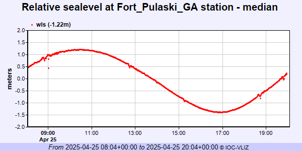 IOC Sea Level Station Monitoring Facility - realtime graph for 'fpga2' 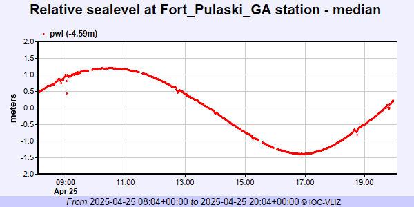 PSMSL Annual Mean Sea Level for '395' 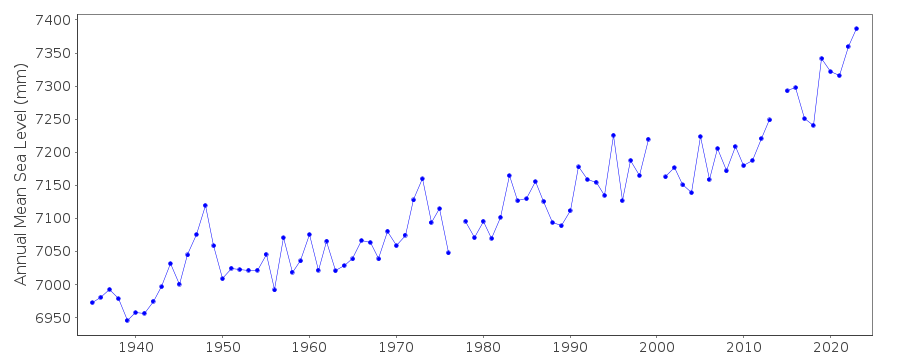 PSMSL Monthly Mean Sea Level for '395' 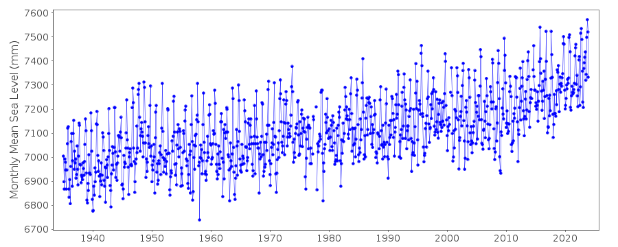
|
|
|