 |
SEALEVEL STATION CATALOG (SSC) |
|
|
|
|
|
| Station catalog metadata [edit] | [station overview] |
|---|
| SSC ID | SSC-fors | | Station Name | Forsmark | | Country | Sweden | | Latitude | 60.4085 | | Longitude | 18.21085 | | DateLastModified | 2023-04-22 21:28:24 |
| Linked codes |
|---|
| Codes | Location | Latitude | Longitude | Sensors | IOC: fors | Forsmark | 60.408611 | 18.210833 | rad |
PSMSL: 2103 | FORSMARK | 60.408611 | 18.210833 | N/A |
| Distributed metadata source: IOC Sea Level Station Monitoring Facility fors |
|---|
| Status | Operational |
| Local Contact | Swedish Meteorological and Hydrological Institute ( Sweden ) |
| Other Contact | Swedish Maritime Administration ( Sweden ) |
| Connection | WEB service |
| Country | Sweden |
| Sensor 1 | |
| Type of sensor | rad |
| Sampling rate (min) | 1 |
| Distributed metadata source: PSMSL |
| Name | FORSMARK |
| SONEL id | 4281 |
| Is RLR | Y |
| Has RLR Diagram | Y link |
| QC Flag | N |
| Old ID | 050/155 |
| Last Updated | 2025-05-27 |
| Supplier | SWEDISH MET. AND HYD. INSTITUTE |
| Address | Swedish Met. and Hyd. Institute, Box 923, S601 76 Norrkoping, SWEDEN |
| Metric Start | 1975 |
| Metric End | 2024 |
| Metric Completeness | 98.8 |
| RLR Start | 1975 |
| RLR End | 2024 |
| RLR Completeness | 98.8 |
| Download metric sea level data. | Use only with extreme caution. |
IOC Sea Level Station Monitoring Facility - realtime graph for 'fors' 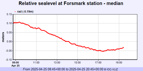 PSMSL Annual Mean Sea Level for '2103' 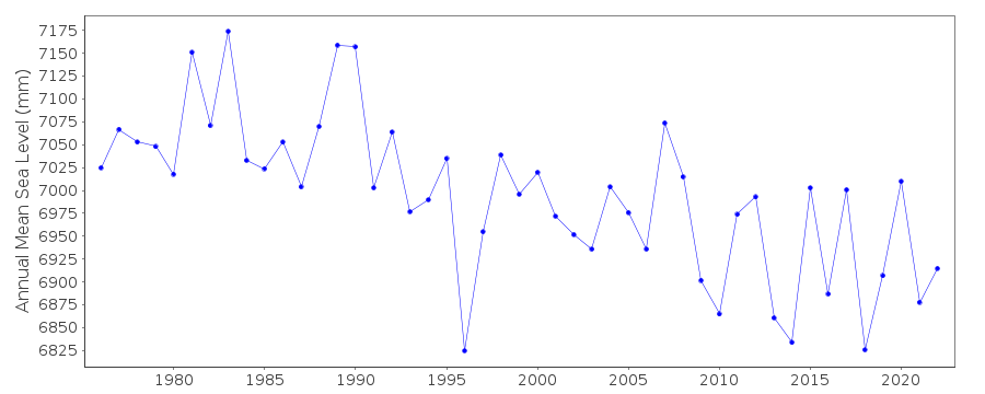 PSMSL Monthly Mean Sea Level for '2103' 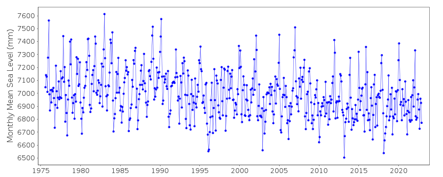
|
|
|