 |
SEALEVEL STATION CATALOG (SSC) |
|
|
|
|
|
| Station catalog metadata [edit] | [station overview] |
|---|
| SSC ID | SSC-espr | | Station Name | Bahia Esperanza | | Country | Argentina | | Latitude | -63.33 | | Longitude | -56.9166 | | DateLastModified | 2015-10-22 19:02:29 |
| Distributed metadata source: IOC Sea Level Station Monitoring Facility espr |
|---|
| GTS station code | 334D4708 |
| GTS message type | XXXXXX |
| Status | Down |
| Local Contact | Armada Argentina Servicio de Hidrografía Naval ( Argentina ) |
| Other Contact | University of Hawaii Sea Level Center ( USA ) |
| Country | Argentina |
| Sensor 1 | |
| Type of sensor | pwl |
| Sampling rate (min) | 6 |
| Sensor 2 | |
| Type of sensor | bwl |
| Sampling rate (min) | 30 |
| Distributed metadata source: GLOSS Station Handbook |
|---|
| Ocean | Southern | | Operational | Yes | | Responsible country | Argentina | | Additional parameters | water/air temperature, wind direction/speed, air pressure | | Tide gauge benchmarks | Benchmark bolt inside tide gauge hut adjacent to stilling well | | Benchmark relationships | Tide gauge zero (TGZ): Local Chart Datum
TGZ is 5.45m below TGBM
| | Auxiliary benchmarks | AUX: Pilar de referencia ubicado en cercauias de la estacion | | Other relevant codes | UHSLC 601 |
| Distributed metadata source: PTWC COMP META file |
| DCP ID | |
| WMO | |
| Samp Rate | |
| Num# Samp | |
| Unit | |
| Scale | |
| Xmt Int. | |
| Fst Min. | |
| HAR | |
| Owner | |
| Distributed metadata source: UHSLC |
| UHSLC id | 601 |
| SSC id | espr |
| GLOSS id | 185 |
| UHSLC geojson | https://uhslc.soest.hawaii.edu/data/meta.geojson |
| Research quality data version a | 1996-01-17 - 1998-08-31 |
| RQ basin | atlantic |
| Fast delivery | 1996-01-17 - 2005-09-11 |
| Distributed metadata source: PSMSL |
| Name | BAHIA ESPERANZA 2 |
| GLOSS id | 185 |
| UHSLC ID | 601 |
| SONEL id | 3589 |
| Is RLR | N |
| Has RLR Diagram | N link |
| QC Flag | N |
| Old ID | 999/010 |
| Last Updated | 1998-12-21 |
| Supplier | N.O.A.A. / N.O.S. |
| Address | N.O.A.A. / N.O.S., N/oes33, Ssmc4, Room 6531, 1305 East-West Highway, Silver Spring, , MD 20910, UNITED STATES |
| Metric Start | 1996 |
| Metric End | 1998 |
| Metric Completeness | 66.7 |
| Download metric sea level data. | Use only with extreme caution. |
| Name | BAHIA ESPERANZA |
| GLOSS id | 185 |
| Is RLR | Y |
| Has RLR Diagram | Y link |
| QC Flag | N |
| Old ID | 999/001 |
| Last Updated | 1999-05-11 |
| Supplier | SERVICIO DE HIDROGRAFIA NAVAL, ARGENTINA |
| Address | Servicio de Hidrografia Naval, Departmento Oceanografia, Av. Montes de Oca 2124, 1271 Buenos Aires, ARGENTINA |
| Metric Start | 1961 |
| Metric End | 1993 |
| Metric Completeness | 35.1 |
| RLR Start | 1961 |
| RLR End | 1993 |
| RLR Completeness | 35.1 |
| Download metric sea level data. | Use only with extreme caution. |
IOC Sea Level Station Monitoring Facility - realtime graph for 'espr'  PSMSL Annual Mean Sea Level for '1889'  PSMSL Annual Mean Sea Level for '988' 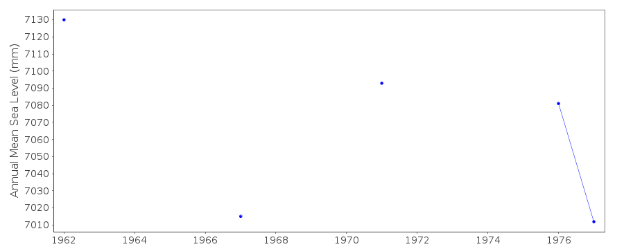 PSMSL Monthly Mean Sea Level for '988' 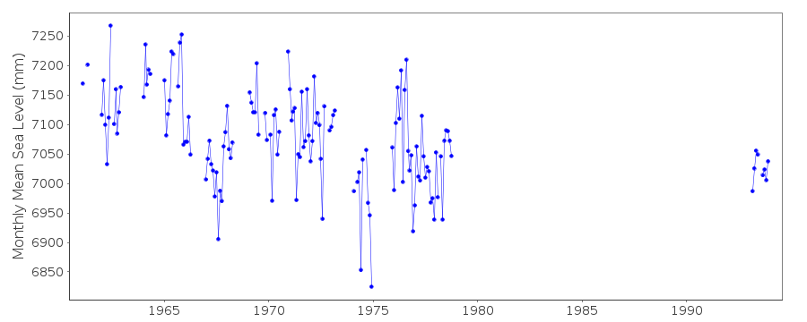
|
|
|