 |
SEALEVEL STATION CATALOG (SSC) |
|
|
|
|
|
| Station catalog metadata [edit] | [station overview] |
|---|
| SSC ID | SSC-durb | | Station Name | Durban | | Country | South Africa | | Latitude | -29.88333 | | Longitude | 31.03333 | | DateLastModified | 2015-10-22 19:02:29 |
| Distributed metadata source: IOC Sea Level Station Monitoring Facility durb |
|---|
| GTS station code | 22DEB682 |
| GTS message type | SXXX33 |
| Status | Down |
| Local Contact | South African Hydrographic Office ( South Africa ) |
| Connection | GTS message |
| Country | South-Africa |
| Sensor 1 | |
| Type of sensor | rad |
| Sampling rate (min) | 1 |
| Distributed metadata source: GLOSS Station Handbook |
|---|
| Time Zone | 030E, GMT + 2hrs | | Ocean | Indian | | Operational | Yes | | Responsible country | South Africa | | Additional parameters | Sea temperature (1990 onwards), air pressure (1990 onwards) | | Tide gauge benchmarks | Trig survey BM 4212 at east end of of Salisbury Island. UTM Grid Reference 36 JUB 109930. | | Benchmark relationships | Tide Gauge Zero (TGZ) = South Africa Chart Datum
TGZ = 0.838m below LLD (MSL) until 31 Dec 1978
TGZ = 0.900m below LLD (MSL) from 01 January 1979
TGZ = 0.904m below BM 4212
| | Other relevant information | Values based on GPS have been observed but not finally calculated. Both gauges are due to be relocated in 1990. | | Other relevant codes | UHSLC 181 | | Nearest Met. station | Durban |
| Distributed metadata source: PTWC COMP META file |
| DCP ID | |
| WMO | |
| Samp Rate | |
| Num# Samp | |
| Unit | |
| Scale | |
| Xmt Int. | |
| Fst Min. | |
| HAR | |
| Owner | |
| Distributed metadata source: UHSLC |
| UHSLC id | 181 |
| SSC id | durb |
| GLOSS id | 13 |
| UHSLC geojson | https://uhslc.soest.hawaii.edu/data/meta.geojson |
| Research quality data version a | 1970-10-01 - 2018-12-30 |
| RQ basin | indian |
| Fast delivery | 1970-10-01 - 2026-04-30 |
| Distributed metadata source: PSMSL |
| Name | DURBAN |
| GLOSS id | 13 |
| UHSLC ID | 181 |
| SONEL id | 3527 |
| Is RLR | Y |
| Has RLR Diagram | Y link |
| QC Flag | N |
| Old ID | 430/091 |
| Last Updated | 2023-11-02 |
| Supplier | DIRECTORATE OF HYDROGRAPHY, S.A. |
| Address | Hydrographic Office, Maritime Headquarters, Private Bag X1, Tokai 7966, SOUTH AFRICA |
| Metric Start | 1926 |
| Metric End | 2022 |
| Metric Completeness | 39.3 |
| RLR Start | 1971 |
| RLR End | 2022 |
| RLR Completeness | 71.3 |
| Download metric sea level data. | Use only with extreme caution. |
IOC Sea Level Station Monitoring Facility - realtime graph for 'durb'  PSMSL Annual Mean Sea Level for '284' 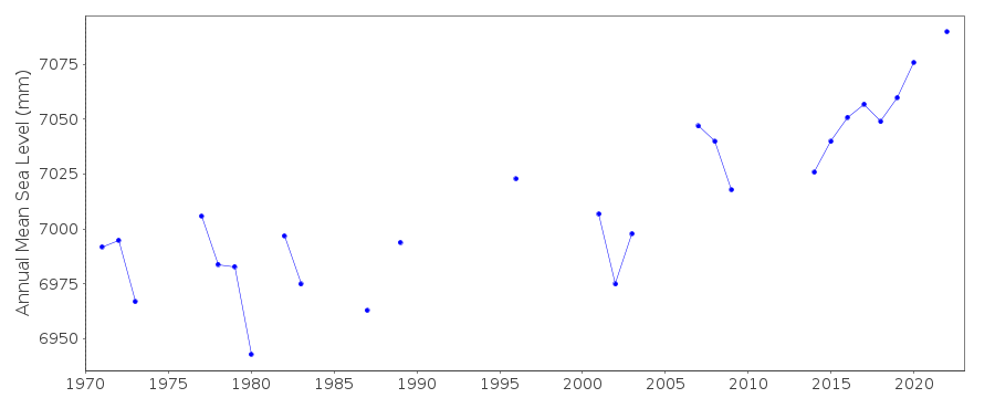 PSMSL Monthly Mean Sea Level for '284' 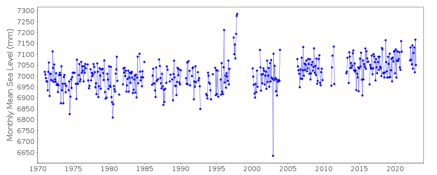
|
|
|