 |
SEALEVEL STATION CATALOG (SSC) |
|
|
|
|
|
| Station catalog metadata [edit] | [station overview] |
|---|
| SSC ID | SSC-diel | | Station Name | Dielette | | Country | France | | Latitude | 49.55 | | Longitude | -1.86 | | DateLastModified | 2015-10-22 19:02:29 |
| Linked codes |
|---|
| Codes | Location | Latitude | Longitude | Sensors | IOC: diel | Dielette | 49.55 | -1.86 | rad |
IOC: diel2 | Dielette 2 | 49.55 | -1.86 | rad |
PSMSL: 2364 | DIELETTE | 49.552499999999995 | -1.86093 | N/A |
| Distributed metadata source: IOC Sea Level Station Monitoring Facility diel |
|---|
| Status | Operational |
| Local Contact | Service hydrographique et océanographique de la marine ( France ) |
| Other Contact | Service hydrographique et océanographique de la marine ( France ) |
| Connection | FTP box |
| Country | France |
| Sensor 1 | |
| Type of sensor | rad |
| Sampling rate (min) | 1 |
| Distributed metadata source: IOC Sea Level Station Monitoring Facility diel2 |
|---|
| GTS station code | FR628 |
| GTS message type | SZFR01 |
| Status | Operational |
| Local Contact | Service hydrographique et océanographique de la marine ( France ) |
| Connection | GTS message |
| Country | France |
| Sensor 1 | |
| Type of sensor | rad |
| Sampling rate (min) | 1 |
| Distributed metadata source: PSMSL |
| Name | DIELETTE |
| Is RLR | Y |
| Has RLR Diagram | Y link |
| QC Flag | N |
| Last Updated | 2026-02-20 |
| Supplier | SERVICE HYD. ET OCEAN. DE LA MARINE |
| Address | SHOM, 13 rue de Chatelier, 29200 BREST , FRANCE |
| Metric Start | 1996 |
| Metric End | 2025 |
| Metric Completeness | 35.0 |
| RLR Start | 1996 |
| RLR End | 2025 |
| RLR Completeness | 35.0 |
| Download metric sea level data. | Use only with extreme caution. |
IOC Sea Level Station Monitoring Facility - realtime graph for 'diel' 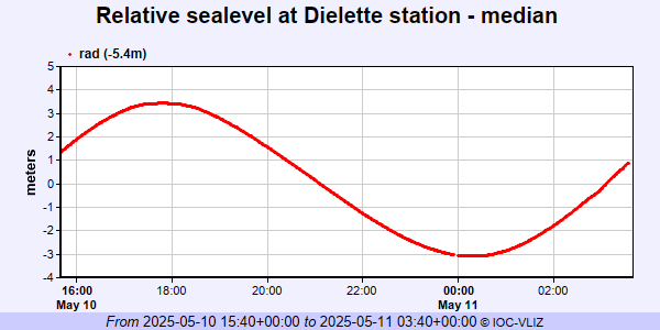 IOC Sea Level Station Monitoring Facility - realtime graph for 'diel2' 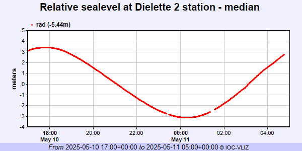 PSMSL Annual Mean Sea Level for '2364' 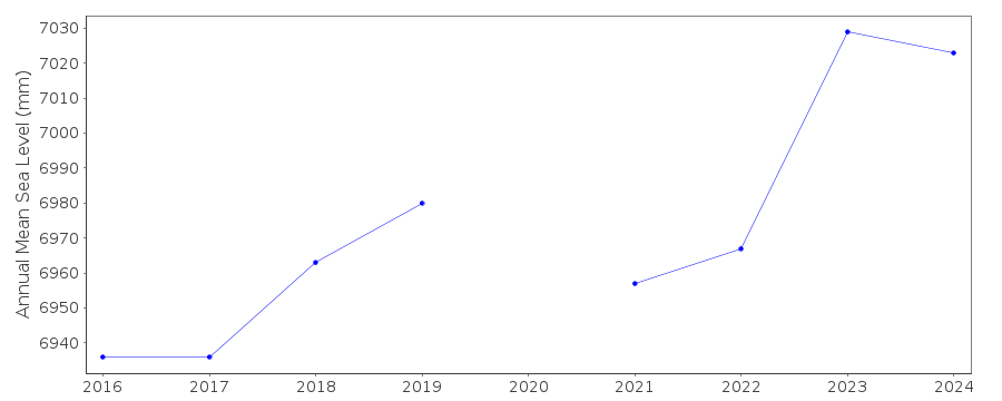 PSMSL Monthly Mean Sea Level for '2364' 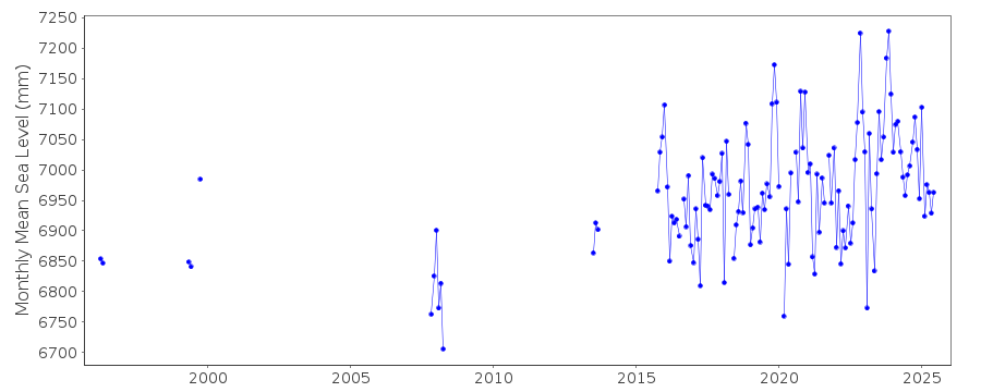
|
|
|