 |
SEALEVEL STATION CATALOG (SSC) |
|
|
|
|
|
| Station catalog metadata [edit] | [station overview] |
|---|
| SSC ID | SSC-davo | | Station Name | Davao | | Country | Philippines | | Latitude | 7.08333 | | Longitude | 125.6333 | | DateLastModified | 2015-10-22 19:02:29 |
| Linked codes |
|---|
| Codes | Location | Latitude | Longitude | Sensors | IOC: davo | Davao_PH | 7.1537 | 125.6629 | prs, rad, ra2, bat, ras, sw2 |
GLOSS: 71 | Davao, Davao Gulf | 7.08333 | 125.63333 | Float |
UHSLC: 372 | Davao | 7.083 | 125.633 | N/A |
PTWC: davo | Davao_PH | 7.1537 | 125.6629 | prs, ra2, rad, ras |
PSMSL: 537 | DAVAO, DAVAO GULF | 7.083333 | 125.633333 | N/A |
SONEL_GPS: 3504 | DAVAO | 7.12649001 | 125.64340510 | N/A |
SONEL_TG: 2824 | DAVAO | 7.08333000 | 125.63330000 | N/A |
| Distributed metadata source: IOC Sea Level Station Monitoring Facility davo |
|---|
| GTS station code | 301434061609060 |
| GTS message type | SZXX01 |
| Status | Operational |
| Local Contact | National Mapping and Resource Information Authority ( Philippines ) |
| Other Contact | University of Hawaii Sea Level Center ( USA ) |
| Connection | GTS message |
| Country | Philippines |
| Sensor 1 | |
| Type of sensor | prs |
| Sampling rate (min) | 1 |
| Sensor 2 | |
| Type of sensor | rad |
| Sampling rate (min) | 1 |
| Sensor 3 | |
| Type of sensor | ra2 |
| Sampling rate (min) | 1 |
| Sensor 4 | |
| Type of sensor | bat |
| Sampling rate (min) | 5 |
| Sensor 5 | |
| Type of sensor | ras |
| Sampling rate (min) | 1 |
| Sensor 6 | |
| Type of sensor | sw2 |
| Sampling rate (min) | 60 |
| Distributed metadata source: GLOSS Station Handbook |
|---|
| Time Zone | 120E, GMT + 8hrs | | Ocean | Pacific | | Operational | Yes | | Responsible country | Philippines | | Additional parameters | Sea surface temperature, surface salinity at 15degC | | Tide gauge benchmarks | BM-11 - Davao City, intersection of Leon Garcia St. and zn Ave., brass rod on concrete foundation of a lamppost on the NW corner of Magsaysay Park. | | Benchmark relationships | BM-11 was established June 1985 | | Auxiliary benchmarks | BH-1A, 8, 14 and 7H | | Other relevant codes | UHSLC 372 | | Nearest Met. station | 10km from tide gauge |
| Distributed metadata source: PTWC COMP META file |
| DCP ID | 301434061609060 |
| WMO | SZXX01 |
| Samp Rate | 1 |
| Num# Samp | 5 |
| Unit | M |
| Scale | 1.0000 |
| Xmt Int. | 005 |
| Fst Min. | 0001 |
| HAR | 1 |
| Owner | UHSLC |
| Distributed metadata source: UHSLC |
| UHSLC id | 372 |
| SSC id | davo |
| GLOSS id | 71 |
| UHSLC geojson | https://uhslc.soest.hawaii.edu/data/meta.geojson |
| Research quality data version a | 1984-01-01 - 1997-07-30 |
| Research quality data version b | 1998-01-01 - 2018-12-31 |
| RQ basin | pacific |
| Fast delivery | 1998-01-01 - 2026-04-30 |
| Distributed metadata source: PSMSL |
| Name | DAVAO, DAVAO GULF |
| GLOSS id | 71 |
| UHSLC ID | 372 |
| Is RLR | Y |
| Has RLR Diagram | N link |
| QC Flag | N |
| Old ID | 660/121 |
| Last Updated | 2025-06-18 |
| Supplier | NATIONAL MAPPING AND RESOURCE INFORMATION AUTHORITY |
| Address | National Mapping and Resource Information Authority, Hydrography Department, 421 Barraca St,, San Nicolas 1010, Manila , PHILIPPINES |
| Metric Start | 1948 |
| Metric End | 2024 |
| Metric Completeness | 81.2 |
| RLR Start | 1948 |
| RLR End | 2024 |
| RLR Completeness | 81.2 |
| Download metric sea level data. | Use only with extreme caution. |
IOC Sea Level Station Monitoring Facility - realtime graph for 'davo' 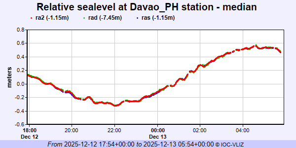 PSMSL Annual Mean Sea Level for '537' 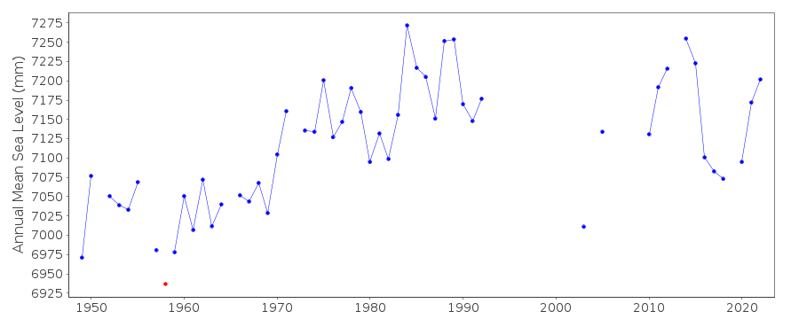 PSMSL Monthly Mean Sea Level for '537' 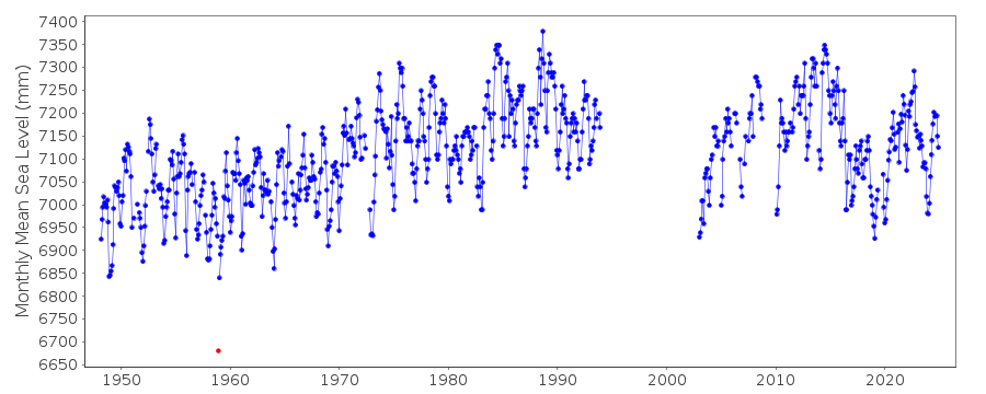
|
|
|