 |
SEALEVEL STATION CATALOG (SSC) |
|
|
|
|
|
| Station catalog metadata [edit] | [station overview] |
|---|
| SSC ID | SSC-darw | | Station Name | Darwin | | Country | Australia | | Latitude | -12.4719 | | Longitude | 130.8458 | | DateLastModified | 2015-10-22 19:02:29 |
| Linked codes |
|---|
| Codes | Location | Latitude | Longitude | Sensors | IOC: darw | Darwin_AU | -12.4719 | 130.8458 | aqu |
GLOSS: 62 | Darwin | -12.46666 | 130.85 | Float, Acoustic |
UHSLC: 168 | Darwin | -12.467 | 130.85 | N/A |
PTWC: darw | Darwin_AU | -12.4719 | 130.8458 | prs |
PSMSL: 935 | DARWIN | -12.471778 | 130.845861 | N/A |
SONEL_GPS: 2930 | DARWIN HARBOUR | -12.42401693 | 130.89148820 | N/A |
SONEL_TG: 2818 | DARWIN HARBOUR | -12.47200000 | 130.84600000 | N/A |
| Distributed metadata source: IOC Sea Level Station Monitoring Facility darw |
|---|
| GTS station code | 63230 |
| GTS message type | SZAU01 |
| Status | Operational |
| Local Contact | National Tidal Centre/Australian Bureau of Meteorology ( Australia ) |
| Connection | GTS message |
| Country | Australia |
| Sensor 1 | |
| Type of sensor | aqu |
| Sampling rate (min) | 1 |
| Distributed metadata source: GLOSS Station Handbook |
|---|
| Ocean | Indian | | Operational | Yes | | Responsible country | Australia | | Additional parameters | barometric pressure, water and air temperature, wind speed and direction | | Tide gauge benchmarks | BM 70/8 bronze plaque at ground level behind kerb at corner of Kitchener Drive and the boom shed road. | | Benchmark relationships | Tide Gauge Zero (TGZ) = Admiralty Chart Datum (ACD)
TGZ = 3.975m below Australian Height Datum (AHD)
TGZ = 10.335m below BM 70/8
| | Auxiliary benchmarks | BM 100: 10x30mm brass block with identification tag set in concrete retaining wall at the abutment of Stokes Hill Wharf.
BM 3046: top of south east corner holding down bolt on base plate of power pole at the abutment of Fort Hill Wharf.
BM 3047: bolt near the tide gauge hut, Fort Hill Wharf.
NTS302
NM/G/21 = Pillar = Coastal Array Primary BM
BM491 Datum for AHD Heights = 28.542m AHD and 32.517m = above Chart Datum
BM 4566 = SEAFRAME Sensor BM =3D 6.374m AHD and 10.349m above Chart Datum
BM 4565 = 27.298m AHD and 31.273m above Chart Datum
BM 4564 = 27.228m AHD and 31.203m above Chart Datum
BM 4479 = 6.368m AHD and 10.343m above Chart Datum
BM 4480 = 6.343m AHD and 10.318m above Chart Datum
BM 4478 = 6.309m AHD and 10.284m above Chart Datum
BM 4481 = 5.491m AHD and 9.466m above Chart Datum
BM 4482 = 5.801m AHD and 9.776m above Chart Datum
| | Other relevant information | Float/stilling well gauge at Fort Hill Wharf (1954-1959).
Float/stilling well gauge at Stokes Hill Wharf (1957-1986).
Float/stilling well gauge at New Fort Hill Wharf (1981 onward).
Geocentric measurement: Precise ephemeris, single point doppler fix U605
Emery Point 1974, approx. 4km from gauge.
| | Other relevant codes | NTF port no. 63230, USHLC 168 | | Nearest Met. station | Darwin Airport |
| Distributed metadata source: PTWC COMP META file |
| DCP ID | 63230 |
| WMO | SZAU01 |
| Samp Rate | 1 |
| Num# Samp | 6 |
| Unit | M |
| Scale | 1.0000 |
| Xmt Int. | 003 |
| Fst Min. | 0000 |
| HAR | 1 |
| Owner | ABM |
| Distributed metadata source: UHSLC |
| UHSLC id | 168 |
| SSC id | darw |
| GLOSS id | 62 |
| UHSLC geojson | https://uhslc.soest.hawaii.edu/data/meta.geojson |
| Research quality data version a | 1984-01-01 - 2021-12-31 |
| RQ basin | indian |
| Fast delivery | 1984-01-01 - 2026-04-30 |
| Distributed metadata source: PSMSL |
| Name | DARWIN |
| GLOSS id | 62 |
| UHSLC ID | 168 |
| SONEL id | 3736 |
| Is RLR | Y |
| Has RLR Diagram | Y link |
| QC Flag | N |
| Old ID | 680/011 |
| Last Updated | 2026-06-01 |
| Supplier | NATIONAL TIDAL CENTRE |
| Address | National Tidal Centre, Bureau of Meteorology, PO Box 421, Kent Town 5071, South Australia, AUSTRALIA |
| Metric Start | 1959 |
| Metric End | 2025 |
| Metric Completeness | 94.3 |
| RLR Start | 1991 |
| RLR End | 2025 |
| RLR Completeness | 99.8 |
| Download metric sea level data. | Use only with extreme caution. |
IOC Sea Level Station Monitoring Facility - realtime graph for 'darw' 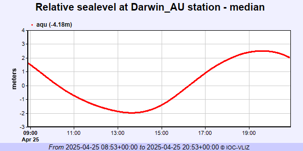 PSMSL Annual Mean Sea Level for '935' 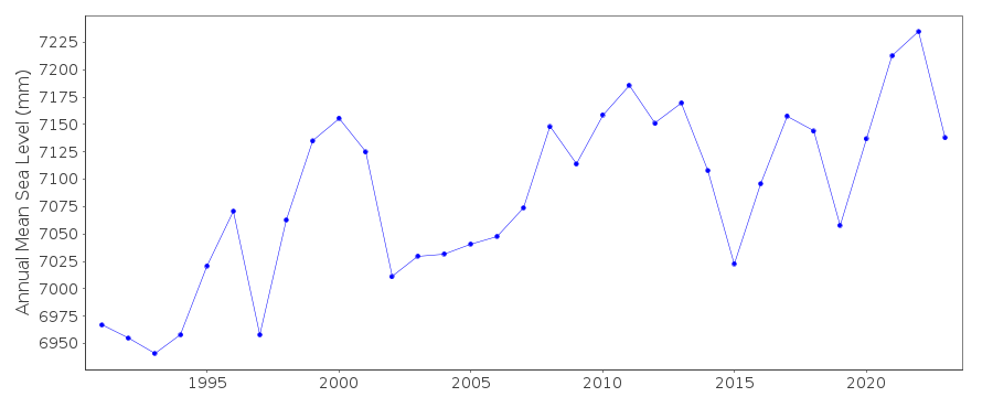 PSMSL Monthly Mean Sea Level for '935' 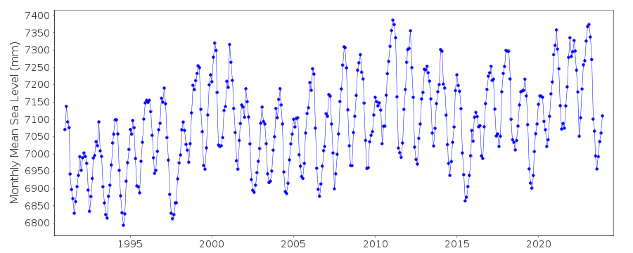
|
|
|