 |
SEALEVEL STATION CATALOG (SSC) |
|
|
|
|
|
| Station catalog metadata [edit] | [station overview] |
|---|
| SSC ID | SSC-colo | | Station Name | Colombo | | Country | Sri Lanka | | Latitude | 6.95 | | Longitude | 79.85 | | DateLastModified | 2015-10-22 19:02:29 |
| Linked codes |
|---|
| Codes | Location | Latitude | Longitude | Sensors | IOC: colb | Colombo | 6.95 | 79.85 | prs, enc, bat, rad, ra2 |
IOC: colo | Colombo | 6.9406 | 79.8503833 | rad, prs, ra2, sw1, sw2, bat |
GLOSS: 33 | Colombo | 6.93333 | 79.85 | Float |
UHSLC: 115 | Colombo | 6.963 | 79.858 | N/A |
PTWC: colb | | | | |
PTWC: colo | Colombo_LK | 6.9402 | 79.8502 | prs, ra2, rad |
PSMSL: 1755 | COLOMBO-B | 6.95 | 79.85 | N/A |
PSMSL: 2194 | COLOMBO C | 6.935 | 79.858333 | N/A |
PSMSL: 388 | COLOMBO | 6.95 | 79.85 | N/A |
PSMSL: 718 | COLOMBO-A | 6.933333 | 79.85 | N/A |
SONEL_GPS: 3582 | COLOMBO | 6.89207500 | 79.87417778 | N/A |
SONEL_TG: 1994 | COLOMBO | 6.93333006 | 79.84999847 | N/A |
| Distributed metadata source: IOC Sea Level Station Monitoring Facility colb |
|---|
| GTS station code | 22373340 |
| GTS message type | SXXX33 |
| Status | Down |
| Local Contact | National Aquatic Resources Research and Development Agency ( Sri Lanka ) |
| Other Contact | University of Hawaii Sea Level Center ( USA ) |
| Connection | GTS message |
| Country | Sri Lanka |
| Sensor 1 | |
| Type of sensor | prs |
| Sampling rate (min) | 1 |
| Sensor 2 | |
| Type of sensor | rad |
| Sampling rate (min) | 3 |
| Sensor 3 | |
| Type of sensor | enc |
| Sampling rate (min) | 6 |
| Sensor 4 | |
| Type of sensor | ra2 |
| Sampling rate (min) | 6 |
| Sensor 5 | |
| Type of sensor | bat |
| Sampling rate (min) | 6 |
| Distributed metadata source: IOC Sea Level Station Monitoring Facility colo |
|---|
| GTS station code | 0650018E |
| GTS message type | SWIO40 |
| Status | Operational |
| Local Contact | National Aquatic Resources Research and Development Agency ( Sri Lanka ) |
| Other Contact | University of Hawaii Sea Level Center ( USA ) |
| Connection | GTS message |
| Country | Sri Lanka |
| Sensor 1 | |
| Type of sensor | prs |
| Sampling rate (min) | 1 |
| Sensor 2 | |
| Type of sensor | rad |
| Sampling rate (min) | 3 |
| Sensor 3 | |
| Type of sensor | ra2 |
| Sampling rate (min) | 3 |
| Sensor 4 | |
| Type of sensor | sw1 |
| Sampling rate (min) | 60 |
| Sensor 5 | |
| Type of sensor | sw2 |
| Sampling rate (min) | 60 |
| Sensor 6 | |
| Type of sensor | bat |
| Sampling rate (min) | 15 |
| Distributed metadata source: GLOSS Station Handbook |
|---|
| Ocean | Indian | | Operational | Yes | | Responsible country | Sri Lanka | | Data acquisition rate | Hourly intervals | | Other relevant information | Daily values calculated using 119-point convolution filter (Bloomfield, 1976) centred on noon applied to the hourly data with respective periods of the 95, 50 and 5% amplitude points at 124.0, 60.2 and 40.2 hours. | | Other relevant codes | UHSLC 115 |
| Distributed metadata source: PTWC COMP META file |
| DCP ID | |
| WMO | |
| Samp Rate | |
| Num# Samp | |
| Unit | |
| Scale | |
| Xmt Int. | |
| Fst Min. | |
| HAR | |
| Owner | |
| Distributed metadata source: UHSLC |
| UHSLC id | 115 |
| SSC id | colo |
| GLOSS id | 33 |
| UHSLC geojson | https://uhslc.soest.hawaii.edu/data/meta.geojson |
| Research quality data version a | 1953-01-02 - 1965-12-31 |
| Research quality data version b | 1989-07-15 - 1992-08-27 |
| Research quality data version c | 2006-05-09 - 2016-10-24 |
| Research quality data version d | 2017-01-05 - 2017-09-04 |
| RQ basin | indian |
| Fast delivery | 2017-01-05 - 2026-04-30 |
| Distributed metadata source: PSMSL |
| Name | COLOMBO-B |
| GLOSS id | 33 |
| UHSLC ID | 115 |
| Is RLR | N |
| Has RLR Diagram | N link |
| QC Flag | N |
| Old ID | 520/003 |
| Last Updated | 2013-10-15 |
| Supplier | NATIONAL AQUATIC RESOURCES AGENCY |
| Address | National Aquatic Resources Agency, Crow Island, Mattakkuliya, Colombo-15, SRI LANKA |
| Metric Start | 1989 |
| Metric End | 1992 |
| Metric Completeness | 77.1 |
| Download metric sea level data. | Use only with extreme caution. |
| Name | COLOMBO C |
| GLOSS id | 33 |
| UHSLC ID | 115 |
| Is RLR | Y |
| Has RLR Diagram | Y link |
| QC Flag | N |
| Old ID | 520/004 |
| Last Updated | 2023-03-07 |
| Supplier | UNIVERSITY OF HAWAII SEA LEVEL CENTER |
| Address | University of Hawaii Sea Level Center, Department of Oceanography Division of Natural Sciences, 1000 Pope Road, Honolulu, Hawaii 96822, UNITED STATES |
| Metric Start | 2006 |
| Metric End | 2016 |
| Metric Completeness | 95.5 |
| RLR Start | 2006 |
| RLR End | 2016 |
| RLR Completeness | 95.5 |
| Download metric sea level data. | Use only with extreme caution. |
| Name | COLOMBO |
| GLOSS id | 33 |
| UHSLC ID | 115 |
| SONEL id | 3582 |
| Is RLR | N |
| Has RLR Diagram | N link |
| QC Flag | N |
| Old ID | 520/001 |
| Last Updated | 2016-01-27 |
| Supplier | N.O.C. |
| Address | British Oceanographic Data Centre, National Oceanography Centre, Joseph Proudman Building, 6 Brownlow Street, Liverpool, L3 5DA, UNITED KINGDOM |
| Metric Start | 1934 |
| Metric End | 1979 |
| Metric Completeness | 8.7 |
| Download metric sea level data. | Use only with extreme caution. |
| Name | COLOMBO-A |
| GLOSS id | 33 |
| UHSLC ID | 115 |
| Is RLR | N |
| Has RLR Diagram | N link |
| QC Flag | N |
| Old ID | 520/002 |
| Last Updated | 1990-12-07 |
| Supplier | NATIONAL AQUATIC RESOURCES AGENCY |
| Address | National Aquatic Resources Agency, Crow Island, Mattakkuliya, Colombo-15, SRI LANKA |
| Metric Start | 1953 |
| Metric End | 1965 |
| Metric Completeness | 94.2 |
| Download metric sea level data. | Use only with extreme caution. |
IOC Sea Level Station Monitoring Facility - realtime graph for 'colb'  IOC Sea Level Station Monitoring Facility - realtime graph for 'colo' 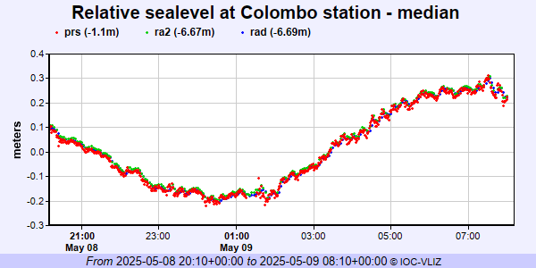 PSMSL Annual Mean Sea Level for '1755'  PSMSL Annual Mean Sea Level for '2194' 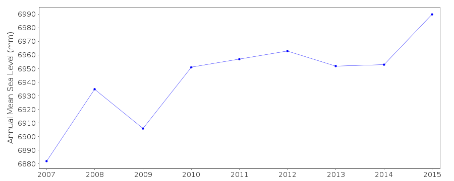 PSMSL Annual Mean Sea Level for '388'  PSMSL Annual Mean Sea Level for '718'  PSMSL Monthly Mean Sea Level for '718' 
|
|
|