 |
SEALEVEL STATION CATALOG (SSC) |
|
|
|
|
|
| Station catalog metadata [edit] | [station overview] |
|---|
| SSC ID | SSC-cocb | | Station Name | Cocos Island | | Country | Australia | | Latitude | -12.1167 | | Longitude | 96.8919 | | DateLastModified | 2015-10-22 19:02:29 |
| Linked codes |
|---|
| Codes | Location | Latitude | Longitude | Sensors | IOC: cocb | Cocos_Island_AU | -12.1167 | 96.8919 | aqu |
GLOSS: 46 | Cocos Is. (Keeling) | -12.7 | 96.9 | Float, Acoustic |
UHSLC: 171 | Cocos | -12.1167 | 96.8917 | N/A |
PTWC: cocb | Cocos_Island_AU | -12.1167 | 96.8919 | aqu |
PSMSL: 1052 | COCOS IS. (WEST IS.) | -12.133333 | 96.816667 | N/A |
PSMSL: 1666 | COCOS ISLAND II | -12.083333 | 96.883333 | N/A |
PSMSL: 983 | COCOS ISLAND (HOME IS.) | -12.116694 | 96.894417 | N/A |
SONEL_GPS: 656 | COCOS ISLAND | -12.18834857 | 96.83396822 | N/A |
SONEL_TG: 2218 | COCOS ISLAND | -12.11665000 | 96.89218100 | N/A |
| Distributed metadata source: IOC Sea Level Station Monitoring Facility cocb |
|---|
| GTS station code | 46280 |
| GTS message type | SZIO01 |
| Status | Operational |
| Local Contact | National Tidal Centre/Australian Bureau of Meteorology ( Australia ) |
| Connection | GTS message |
| Country | Australia |
| Sensor 1 | |
| Type of sensor | aqu |
| Sampling rate (min) | 1 |
| Distributed metadata source: GLOSS Station Handbook |
|---|
| Ocean | Indian | | Operational | Yes | | Responsible country | Australia | | Data acquisition rate | 6 minute interval | | Additional parameters | barometric pressure, water/air temperature, wind speed & direction | | Tide gauge benchmarks | PSM 101: brass plaque in concrete at the base of the jetty on Home Is. | | Benchmark relationships | Tide Gauge Zero (TGZ) = 2.410m below PMS 101.
TGZ = 0.784m below Home Island Datum (approx. mean sea level)
| | Auxiliary benchmarks | PSM 91: brass plug in concrete wharf (northern wall), Home Island.
Trig R379: An RA Survey brass plaque stamped R379 set in concrete at ground level, situated on the most SW point of Home Island, adjacent to the Clunies Ross Residence.
| | Other relevant information | Float/stilling well gauge (1961-1965) located on original jetty West Is.
Float/stilling well gauge (1968-1971) located near jetty, West Is.
Geocentric measurements: Doppler observations 1969 ISTS 040 on West Is.
PSMSL also hold data from another gauge at Cocos Island (Keeling) (PSMSL Code 680/522, 1985-1987).
| | Other relevant codes | NTF port no. 46280, UHSLC 171 |
| Distributed metadata source: PTWC COMP META file |
| DCP ID | 46280 |
| WMO | SZIO01 |
| Samp Rate | 1 |
| Num# Samp | 6 |
| Unit | M |
| Scale | 1.0000 |
| Xmt Int. | 003 |
| Fst Min. | 0000 |
| HAR | 1 |
| Owner | ABM |
| Distributed metadata source: UHSLC |
| UHSLC id | 171 |
| SSC id | cocb |
| GLOSS id | 46 |
| UHSLC geojson | https://uhslc.soest.hawaii.edu/data/meta.geojson |
| Research quality data version a | 1985-12-11 - 2021-12-31 |
| RQ basin | indian |
| Fast delivery | 1985-12-11 - 2026-05-31 |
| Distributed metadata source: PSMSL |
| Name | COCOS IS. (WEST IS.) |
| GLOSS id | 46 |
| UHSLC ID | 171 |
| Is RLR | N |
| Has RLR Diagram | N link |
| QC Flag | N |
| Old ID | 680/520 |
| Last Updated | 2000-06-30 |
| Supplier | NATIONAL TIDAL CENTRE |
| Address | National Tidal Centre, Bureau of Meteorology, PO Box 421, Kent Town 5071, South Australia, AUSTRALIA |
| Metric Start | 1963 |
| Metric End | 1971 |
| Metric Completeness | 53.7 |
| Download metric sea level data. | Use only with extreme caution. |
| Name | COCOS ISLAND II |
| GLOSS id | 46 |
| UHSLC ID | 171 |
| Is RLR | N |
| Has RLR Diagram | N link |
| QC Flag | N |
| Old ID | 680/522 |
| Last Updated | 1993-05-24 |
| Supplier | NATIONAL TIDAL FACILITY |
| Address | National Tidal Facility, G.P.O. Box 2100, S.A. 5001, Adelaide , AUSTRALIA |
| Metric Start | 1985 |
| Metric End | 1987 |
| Metric Completeness | 58.3 |
| Download metric sea level data. | Use only with extreme caution. |
| Name | COCOS ISLAND (HOME IS.) |
| GLOSS id | 46 |
| UHSLC ID | 171 |
| SONEL id | 656 |
| Is RLR | Y |
| Has RLR Diagram | Y link |
| QC Flag | N |
| Old ID | 680/521 |
| Last Updated | 2025-03-20 |
| Supplier | NATIONAL TIDAL CENTRE |
| Address | National Tidal Centre, Bureau of Meteorology, PO Box 421, Kent Town 5071, South Australia, AUSTRALIA |
| Metric Start | 1961 |
| Metric End | 2025 |
| Metric Completeness | 60.3 |
| RLR Start | 1993 |
| RLR End | 2025 |
| RLR Completeness | 96.0 |
| Download metric sea level data. | Use only with extreme caution. |
IOC Sea Level Station Monitoring Facility - realtime graph for 'cocb' 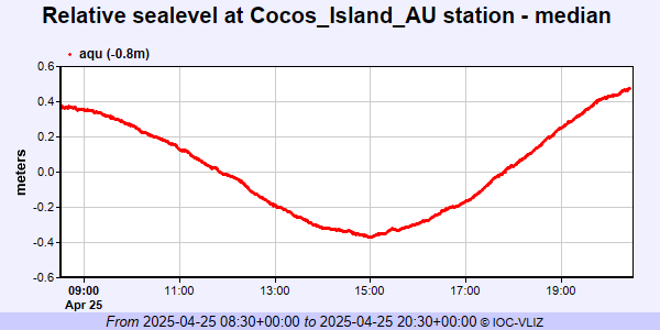 PSMSL Annual Mean Sea Level for '1052'  PSMSL Annual Mean Sea Level for '1666'  PSMSL Annual Mean Sea Level for '983' 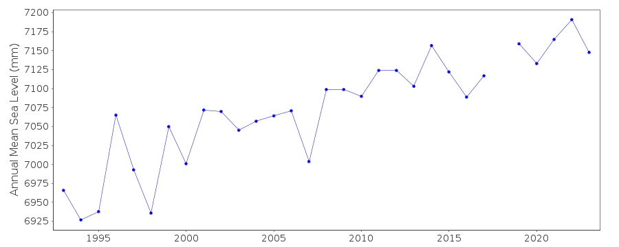 PSMSL Monthly Mean Sea Level for '983' 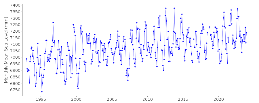
|
|
|