 |
SEALEVEL STATION CATALOG (SSC) |
|
|
|
|
|
| Station catalog metadata [edit] | [station overview] |
|---|
| SSC ID | SSC-chuu | | Station Name | Chuuk Atoll | | Country | Micronesia | | Latitude | 7.45 | | Longitude | 151.85 | | DateLastModified | 2015-10-22 19:02:29 |
| Linked codes |
|---|
| Codes | Location | Latitude | Longitude | Sensors | IOC: chuu | Chuuk | 7.4536833 | 151.8982417 | rad, bat, prs, ra2 |
GLOSS: 116 | Chuuk Atoll, Caroline Is. | 7.45 | 151.85 | Bubbler |
UHSLC: 54 | Chuuk | 7.45368 | 151.89819 | N/A |
PTWC: chuk | Chuuk_FM | 7.4537 | 151.8982 | rad |
PSMSL: 528 | CHUUK, MOEN ISLAND | 7.446667 | 151.846667 | N/A |
SONEL_GPS: 2626 | CHUUK | 7.44700000 | 151.88720000 | N/A |
SONEL_TG: 2625 | CHUUK | 7.44420900 | 151.84082800 | N/A |
| Distributed metadata source: IOC Sea Level Station Monitoring Facility chuu |
|---|
| GTS station code | 300434063442310 |
| GTS message type | SZXX01 |
| Status | Operational |
| Local Contact | Korea-South Pacific Ocean Research Center ( Korea ) |
| Other Contact | University of Hawaii Sea Level Center ( USA ) |
| Connection | GTS message |
| Country | Micronesia |
| Sensor 1 | |
| Type of sensor | rad |
| Sampling rate (min) | 1 |
| Sensor 2 | |
| Type of sensor | bat |
| Sampling rate (min) | 5 |
| Sensor 3 | |
| Type of sensor | prs |
| Sampling rate (min) | 1 |
| Sensor 4 | |
| Type of sensor | ra2 |
| Sampling rate (min) | 1 |
| Distributed metadata source: GLOSS Station Handbook |
|---|
| Time Zone | 150E, GMT + 10hrs | | Ocean | Pacific | | Operational | Yes | | Additional parameters | Surface temperature, density | | Tide gauge benchmarks | Benchmark B(1948) is the primary benchmark stamped 'B 1948' set in concrete pavement along the north side of a row of 6 Quonset warehouses east of the government pier. | | Benchmark relationships | Tide Gauge Benchmark is 8.05ft above the Tide Gauge Zero (Station Datum).
NOAA Chart Datum is 2.73ft above Station Datum.
Mean Sea Level (1960-1978) is 3.58ft above Station Datum.
| | Auxiliary benchmarks | 5 additional benchmarks are levelled to the TGBM and tide station on a yearly basis | | Other relevant codes | UHSLC 054 |
| Distributed metadata source: PTWC COMP META file |
| DCP ID | 300434063442310 |
| WMO | SZXX01 |
| Samp Rate | 1 |
| Num# Samp | 5 |
| Unit | M |
| Scale | 1.0000 |
| Xmt Int. | 005 |
| Fst Min. | 0001 |
| HAR | 0 |
| Owner | UHSLC |
| Distributed metadata source: UHSLC |
| UHSLC id | 054 |
| SSC id | chuu |
| GLOSS id | 116 |
| UHSLC geojson | https://uhslc.soest.hawaii.edu/data/meta.geojson |
| Research quality data version a | 1947-10-01 - 1991-12-31 |
| Research quality data version b | 2020-07-28 - 2024-12-31 |
| RQ basin | pacific |
| Fast delivery | 2020-07-28 - 2026-05-31 |
| Distributed metadata source: PSMSL |
| Name | CHUUK, MOEN ISLAND |
| GLOSS id | 116 |
| UHSLC ID | 54 |
| SONEL id | 2626 |
| Is RLR | Y |
| Has RLR Diagram | Y link |
| QC Flag | N |
| Old ID | 710/001 |
| Last Updated | 2000-03-10 |
| Supplier | N.O.A.A. / N.O.S. |
| Address | N.O.A.A. / N.O.S., N/oes33, Ssmc4, Room 6531, 1305 East-West Highway, Silver Spring, , MD 20910, UNITED STATES |
| Metric Start | 1947 |
| Metric End | 1995 |
| Metric Completeness | 83.3 |
| RLR Start | 1947 |
| RLR End | 1995 |
| RLR Completeness | 83.3 |
| Download metric sea level data. | Use only with extreme caution. |
IOC Sea Level Station Monitoring Facility - realtime graph for 'chuu' 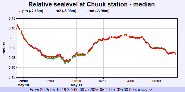 PSMSL Annual Mean Sea Level for '528' 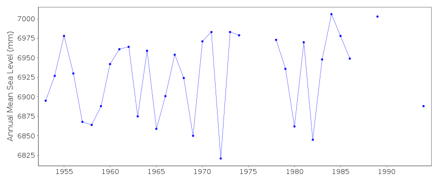 PSMSL Monthly Mean Sea Level for '528' 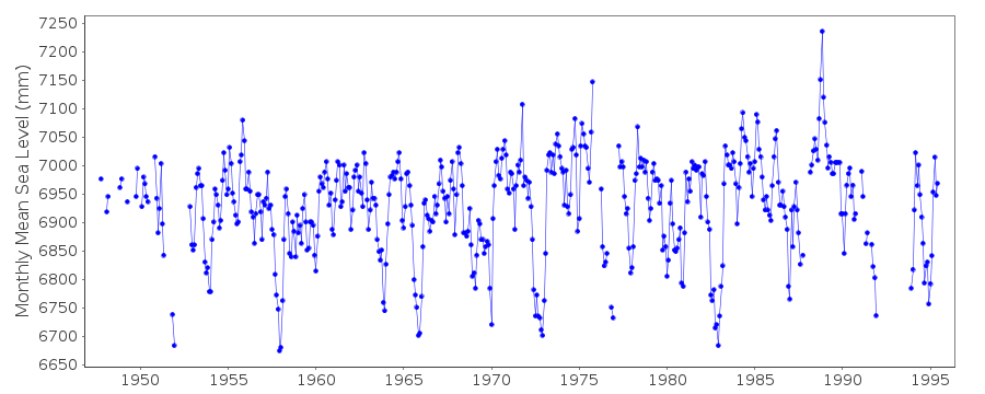
|
|
|