 |
SEALEVEL STATION CATALOG (SSC) |
|
|
|
|
|
| Station catalog metadata [edit] | [station overview] |
|---|
| SSC ID | SSC-chen | | Station Name | Chendering/Kuala Terengganu | | Country | Malaysia | | Latitude | 5.26666 | | Longitude | 103.18333 | | DateLastModified | 2015-10-22 19:02:29 |
| Distributed metadata source: GLOSS Station Handbook |
|---|
| Time Zone | 120E, GMT + 8hrs | | Ocean | Pacific | | Operational | Yes | | Responsible country | Malaysia | | Additional parameters | None | | Tide gauge benchmarks | Survey Department Benchmark No. T0283 situated on the left corner of the T-junction on the jetty facing the the Fisheries Complex. Benchmark T0283 is 2.756m above Land Survey Datum (LSD 1912 - Port Klang). | | Benchmark relationships | Tide Gauge Zero (TGZ) = 4.688 below benchmark T0283 | | Auxiliary benchmarks | Standard Mark bolt inside tidal house, adjacent to stilling well.
Standard benchmark S0149, S0150 and S0148 and also benchmark T0282
| | Other relevant information | Additional authority responsible for maintaining gauge: Director of Topographical Survey, 5th Floor, Wisma Awal, Jalan Raja Muda Abdul Aziz, Kampung Baru, 50300 Kuala Lumpar
The Director of Geodesy, DSMM, is responsible for the maintenance of the tide gauge stations available around the coast of Malaysia.
| | Other relevant codes | UHSLC 320 |
| Distributed metadata source: UHSLC |
| UHSLC id | 320 |
| SSC id | chen |
| GLOSS id | 293 |
| UHSLC geojson | https://uhslc.soest.hawaii.edu/data/meta.geojson |
| Research quality data version a | 1984-11-01 - 2023-01-15 |
| RQ basin | pacific |
| Distributed metadata source: PSMSL |
| Name | CENDERING |
| GLOSS id | 293 |
| UHSLC ID | 320 |
| SONEL id | 2640 |
| Is RLR | Y |
| Has RLR Diagram | Y link |
| QC Flag | N |
| Old ID | 550/017 |
| Last Updated | 2019-09-11 |
| Supplier | DEPARTMENT OF SURVEY AND MAPPING |
| Address | Department of Survey and Mapping, Wisma JUPEM, Jalan Semarak, 50578 Kuala Lumpur, MALAYSIA |
| Metric Start | 1984 |
| Metric End | 2018 |
| Metric Completeness | 88.8 |
| RLR Start | 1984 |
| RLR End | 2018 |
| RLR Completeness | 88.8 |
| Download metric sea level data. | Use only with extreme caution. |
PSMSL Annual Mean Sea Level for '1592' 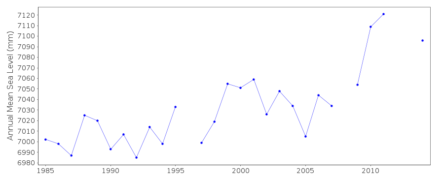 PSMSL Monthly Mean Sea Level for '1592' 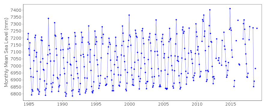
|
|
|