 |
SEALEVEL STATION CATALOG (SSC) |
|
|
|
|
|
| Station catalog metadata [edit] | [station overview] |
|---|
| SSC ID | SSC-catn | | Station Name | Catania | | Country | Italy | | Latitude | 37.498 | | Longitude | 15.0938 | | DateLastModified | 2015-10-22 19:28:26 |
| Distributed metadata source: IOC Sea Level Station Monitoring Facility CT03 |
|---|
| Status | Operational |
| Local Contact | Istituto Superiore per la Protezione e la Ricerca Ambientale ( Italy ) |
| Connection | WEB service |
| Country | Italy |
| Sensor 1 | |
| Type of sensor | rad |
| Sampling rate (min) | 1 |
| Distributed metadata source: PTWC COMP META file |
| DCP ID | 1234AACD |
| WMO | FTPI00 |
| Samp Rate | 1 |
| Num# Samp | 10 |
| Unit | m |
| Scale | 1.0000 |
| Xmt Int. | 010 |
| Fst Min. | 0000 |
| HAR | 1 |
| Owner | ISPRA |
| Distributed metadata source: PSMSL |
| Name | CATANIA |
| SONEL id | 2253 |
| Is RLR | Y |
| Has RLR Diagram | Y link |
| QC Flag | N |
| Old ID | 260/031 |
| Last Updated | null |
| Supplier | CNR - ISTITUTO DI SCIENZE MARINE |
| Address | CNR - Istituto di Scienze Marine, AREA Science Park, Basovizza, I-34149 Trieste, ITALY |
| Metric Start | 1896 |
| Metric End | 1971 |
| Metric Completeness | 45.0 |
| RLR Start | 1960 |
| RLR End | 1971 |
| RLR Completeness | 100.0 |
| Download metric sea level data. | Use only with extreme caution. |
| Name | CATANIA II |
| Is RLR | Y |
| Has RLR Diagram | Y link |
| QC Flag | N |
| Old ID | 260/032 |
| Last Updated | 2026-05-08 |
| Supplier | ISPRA |
| Address | Institute for Environmental Protection and Research, Via Vitaliano , Brancati 48, 00144 Roma, ITALY |
| Metric Start | 2001 |
| Metric End | 2025 |
| Metric Completeness | 98.7 |
| RLR Start | 2001 |
| RLR End | 2025 |
| RLR Completeness | 98.7 |
| Download metric sea level data. | Use only with extreme caution. |
IOC Sea Level Station Monitoring Facility - realtime graph for 'CT03' 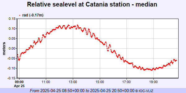 PSMSL Annual Mean Sea Level for '102' 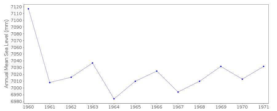 PSMSL Annual Mean Sea Level for '2094' 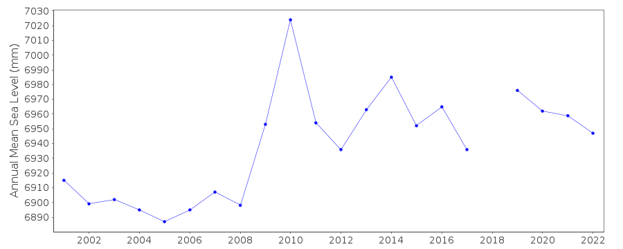 PSMSL Monthly Mean Sea Level for '2094' 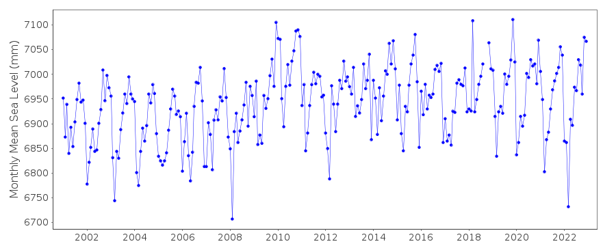
|
|
|