 |
SEALEVEL STATION CATALOG (SSC) |
|
|
|
|
|
| Station catalog metadata [edit] | [station overview] |
|---|
| SSC ID | SSC-busa | | Station Name | Busan | | Country | South Korea | | Latitude | 35.093056 | | Longitude | 129.0375 | | DateLastModified | 2015-10-22 19:02:29 |
| Distributed metadata source: IOC Sea Level Station Monitoring Facility busa |
|---|
| Status | Operational |
| Local Contact | Korea Hydrographic and Oceanographic Administration ( Korea ) |
| Other Contact | Korea Environmental Science & Technology Institute ( Korea ) |
| Connection | FTP box |
| Country | Korea, Southern [Han Kook] |
| Sensor 1 | |
| Type of sensor | rad |
| Sampling rate (min) | 1 |
| Distributed metadata source: GLOSS Station Handbook |
|---|
| Time Zone | 135E, GMT + 9hrs | | Ocean | Pacific | | Operational | Yes | | Tide gauge benchmarks | Tidal Bench Mark (Bronze) inside tide gauge hut | | Benchmark relationships | Tide gauge zero (TGZ) = 3.544m below tide gauge benchmark
TGZ = 2.554m below TBM No. 1
TGZ = 2.525m below TBM No. 2
|
| Distributed metadata source: PTWC COMP META file |
| DCP ID | 1234AAA0 |
| WMO | FTPI00 |
| Samp Rate | 1 |
| Num# Samp | 10 |
| Unit | m |
| Scale | 1.0000 |
| Xmt Int. | 010 |
| Fst Min. | 0000 |
| HAR | 1 |
| Owner | KHOA |
| Distributed metadata source: PSMSL |
| Name | BUSAN |
| GLOSS id | 84 |
| Is RLR | Y |
| Has RLR Diagram | N link |
| QC Flag | N |
| Old ID | 620/046 |
| Last Updated | 2026-04-10 |
| Supplier | KOREA HYDROGRAPHIC AND OCEANOGRAPHIC AGENCY (KHOA) |
| Address | Korea Hydrographic and Oceanographic Agency (KHOA), 351, Haeyang-ro, Yeongdo-gu, Busan, Republic of Korea, KOREA, REPUBLIC OF |
| Metric Start | 1960 |
| Metric End | 2024 |
| Metric Completeness | 99.1 |
| RLR Start | 1960 |
| RLR End | 2024 |
| RLR Completeness | 99.1 |
| Download metric sea level data. | Use only with extreme caution. |
IOC Sea Level Station Monitoring Facility - realtime graph for 'busa'  PSMSL Annual Mean Sea Level for '955' 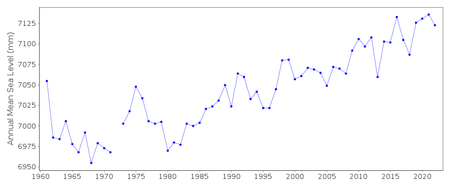 PSMSL Monthly Mean Sea Level for '955' 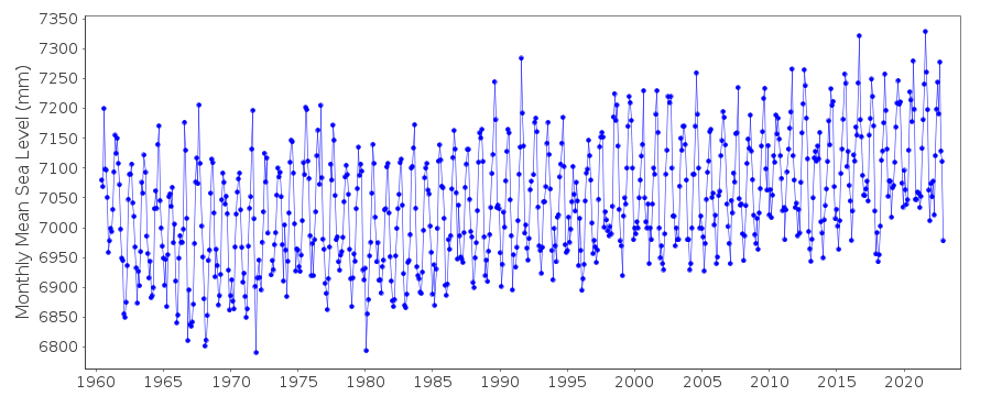
|
|
|