 |
SEALEVEL STATION CATALOG (SSC) |
|
|
|
|
|
| Station catalog metadata [edit] | [station overview] |
|---|
| SSC ID | SSC-bres | | Station Name | Brest | | Country | France | | Latitude | 48.38 | | Longitude | -4.5 | | DateLastModified | 2015-10-22 19:02:29 |
| Distributed metadata source: IOC Sea Level Station Monitoring Facility bres |
|---|
| Status | Operational |
| Local Contact | Service hydrographique et océanographique de la marine ( France ) |
| Other Contact | Service hydrographique et océanographique de la marine ( France ) |
| Connection | FTP box |
| Country | France |
| Sensor 1 | |
| Type of sensor | rad |
| Sampling rate (min) | 1 |
| Distributed metadata source: IOC Sea Level Station Monitoring Facility bres2 |
|---|
| GTS station code | FR0001 |
| GTS message type | SZFR01 |
| Status | In test |
| Local Contact | Service hydrographique et océanographique de la marine ( France ) |
| Other Contact | Service hydrographique et océanographique de la marine ( France ) |
| Connection | GTS message |
| Country | France |
| Sensor 1 | |
| Type of sensor | rad |
| Sampling rate (min) | 1 |
| Distributed metadata source: GLOSS Station Handbook |
|---|
| Time Zone | 015E, GMT + 1hrs | | Ocean | Atlantic | | Operational | Yes | | Responsible country | France | | Tide gauge benchmarks | Repere A: repere no.1 NGF situe sur le polier est, pres de l'entree Nord du tunnel | | Benchmark relationships | Repere A = 5.589m
Repere B = 5.670m
Repere C = 5.481m
Repere D = 4.492m
Repere F = 4.807m
Repere G = 4.349m
Cote par rapport au zero NGF
| | Auxiliary benchmarks | Repere B: repere no.2 NGF situe a l'entree Sud du tunnel du chateau.
Repere C: macaron no.0-o NGF scelle a droite de l'entree NW des souterrains du chateau.
Repere D: rivet no.0-I NGF scelle sur le quai a droite de la passerelle d'acces au maregraphe.
Repere G: echelle E3 - graduation 8.80m.
| | Other relevant information | Other benchmark:
Repere F: repere SH no.0 NGF situe sur la margelle du puits du maregraphe sans capuchon (installe par T.M. en 1963).
Met. data are held by Meteo France - centre departmental Finistere - aerodrome 29490 Guipavas.
| | Nearest Met. station | Meteo France - Guipavas statio |
| Distributed metadata source: UHSLC |
| UHSLC id | 822 |
| SSC id | bres |
| GLOSS id | 242 |
| UHSLC geojson | https://uhslc.soest.hawaii.edu/data/meta.geojson |
| Research quality data version a | 1846-01-04 - 2018-12-31 |
| RQ basin | atlantic |
| Fast delivery | 1846-01-04 - 2026-04-30 |
| Distributed metadata source: PSMSL |
| Name | BREST |
| GLOSS id | 242 |
| UHSLC ID | 822 |
| SONEL id | 3180 |
| Is RLR | Y |
| Has RLR Diagram | Y link |
| QC Flag | N |
| Old ID | 190/091 |
| Last Updated | 2026-02-20 |
| Supplier | SERVICE HYD. ET OCEAN. DE LA MARINE |
| Address | SHOM, 13 rue de Chatelier, 29200 BREST , FRANCE |
| Metric Start | 1807 |
| Metric End | 2025 |
| Metric Completeness | 87.9 |
| RLR Start | 1807 |
| RLR End | 2025 |
| RLR Completeness | 87.9 |
| Download metric sea level data. | Use only with extreme caution. |
IOC Sea Level Station Monitoring Facility - realtime graph for 'bres' 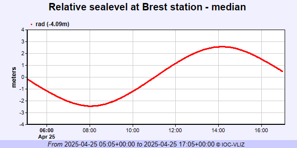 IOC Sea Level Station Monitoring Facility - realtime graph for 'bres2'  PSMSL Annual Mean Sea Level for '1' 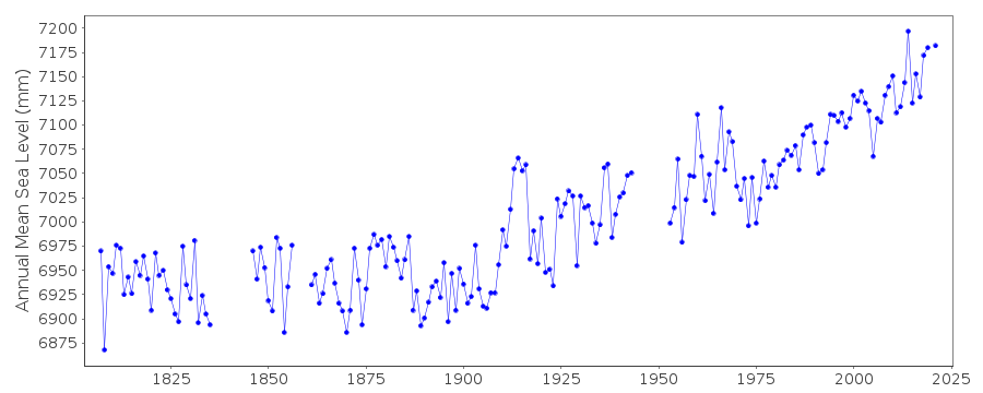 PSMSL Monthly Mean Sea Level for '1' 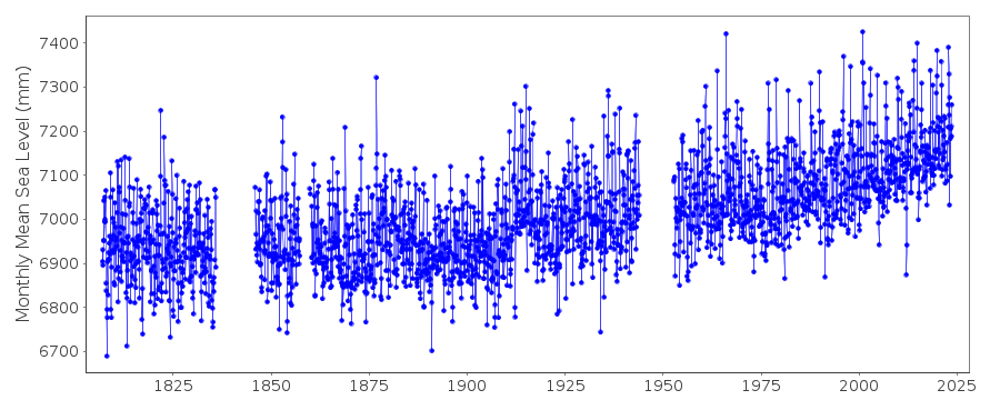
|
|
|