 |
SEALEVEL STATION CATALOG (SSC) |
|
|
|
|
|
| Station catalog metadata [edit] | [station overview] |
|---|
| SSC ID | SSC-bluf | | Station Name | Bluff | | Country | New Zealand | | Latitude | -46.6 | | Longitude | 168.35 | | DateLastModified | 2015-10-22 19:02:29 |
| Distributed metadata source: GLOSS Station Handbook |
|---|
| Time Zone | 180E, GMT + 12hrs | | Ocean | Pacific | | Operational | Yes | | Responsible country | New Zealand | | Additional parameters | Barometric pressure | | Tide gauge benchmarks | Bluff Fundamental Benchmark, stainless steel pin in concrete under iron cover in grounds of Police Station, corner of Lee and Barrow Streets. | | Benchmark relationships | Tide Gauge Zero (TGZ) = 8.620m below Bluff Fundamental Benchmark
TGZ = 4.883m below War Memorial Benchmark
| | Auxiliary benchmarks | Aux 1 - War Memorial Benchmark, War Memorial, Marine Parade, copper pin in centre of bottom step, west side. | | Other relevant information | The old gauge is soon to be replaced. An analogue tide gauge using an ultrasonic sensor in a filtered stilling well was installed in 1989. It is not presently equipped to give data in computer compatible form. Record will be continuous and adjusted to hourly heights. Equipment was commissioned in 1990. | | Other relevant codes | UHSLC 072 | | Nearest Met. station | Invercargill Airport |
| Distributed metadata source: UHSLC |
| UHSLC id | 072 |
| SSC id | bluf |
| GLOSS id | 129 |
| UHSLC geojson | https://uhslc.soest.hawaii.edu/data/meta.geojson |
| Research quality data version a | 1984-10-01 - 2024-12-31 |
| RQ basin | pacific |
| Fast delivery | 1984-10-01 - 2026-05-31 |
| Distributed metadata source: PSMSL |
| Name | BLUFF (SOUTHLAND HARBOUR) |
| GLOSS id | 129 |
| UHSLC ID | 72 |
| SONEL id | 2907 |
| Is RLR | Y |
| Has RLR Diagram | Y link |
| QC Flag | N |
| Old ID | 690/041 |
| Last Updated | 2026-02-17 |
| Supplier | LAND INFORMATION NEW ZEALAND (LINZ) |
| Address | Land Information New Zealand , 155 The Terrace, PO 5501, Wellington 6145, NEW ZEALAND |
| Metric Start | 1917 |
| Metric End | 2025 |
| Metric Completeness | 34.0 |
| RLR Start | 1917 |
| RLR End | 2025 |
| RLR Completeness | 34.0 |
| Download metric sea level data. | Use only with extreme caution. |
PSMSL Annual Mean Sea Level for '213' 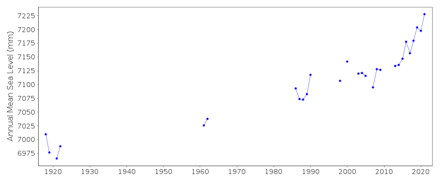 PSMSL Monthly Mean Sea Level for '213' 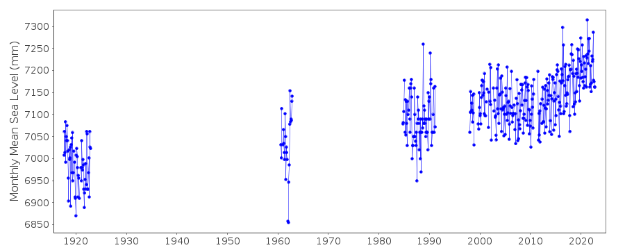
|
|
|