 |
SEALEVEL STATION CATALOG (SSC) |
|
|
|
|
|
| Station catalog metadata [edit] | [station overview] |
|---|
| SSC ID | SSC-bara | | Station Name | Barahona | | Country | Dominican Republic | | Latitude | 18.208137 | | Longitude | -71.092154 | | DateLastModified | 2015-10-22 19:02:29 |
| Linked codes |
|---|
| Codes | Location | Latitude | Longitude | Sensors | IOC: bara | Barahona | 18.208137 | -71.092154 | prs, rad, bat |
PTWC: bara | Barahona_DO | 18.2081 | -71.0922 | prs, rad |
PSMSL: 745 | BARAHONA | 18.2 | -71.083333 | N/A |
SONEL_GPS: 3554 | BARAHONA | 18.20860000 | -71.09800000 | N/A |
SONEL_TG: 3553 | BARAHONA | 18.20000000 | -71.08300000 | N/A |
| Distributed metadata source: IOC Sea Level Station Monitoring Facility bara |
|---|
| GTS station code | 04401622 |
| GTS message type | SXDR40 |
| Status | Operational |
| Local Contact | Oficina Nacional de Meteorología (Dominican Republic) |
| Other Contact | Puerto Rico Seismic Network ( USA ) |
| Other Contact | International Tsunami Information Center Caribbean Office ( USA ) |
| Connection | GTS message |
| Country | Dominican Republic |
| Sensor 1 | |
| Type of sensor | rad |
| Sampling rate (min) | 1 |
| Sensor 2 | |
| Type of sensor | bat |
| Sampling rate (min) | 5 |
| Sensor 3 | |
| Type of sensor | prs |
| Sampling rate (min) | 1 |
| Distributed metadata source: PTWC COMP META file |
| DCP ID | 04401622 |
| WMO | SXDR40 |
| Samp Rate | 1 |
| Num# Samp | 10 |
| Unit | M |
| Scale | 1.0000 |
| Xmt Int. | 005 |
| Fst Min. | 0000 |
| HAR | 1 |
| Owner | PRSN |
| Distributed metadata source: PSMSL |
| Name | BARAHONA |
| SONEL id | 3653 |
| Is RLR | Y |
| Has RLR Diagram | Y link |
| QC Flag | N |
| Old ID | 936/011 |
| Last Updated | null |
| Supplier | N.O.A.A. / N.O.S. |
| Address | N.O.A.A. / N.O.S., N/oes33, Ssmc4, Room 6531, 1305 East-West Highway, Silver Spring, , MD 20910, UNITED STATES |
| Metric Start | 1954 |
| Metric End | 1969 |
| Metric Completeness | 64.1 |
| RLR Start | 1954 |
| RLR End | 1969 |
| RLR Completeness | 64.1 |
| Download metric sea level data. | Use only with extreme caution. |
IOC Sea Level Station Monitoring Facility - realtime graph for 'bara' 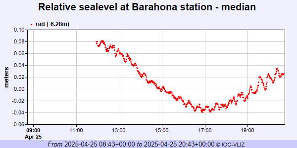 PSMSL Annual Mean Sea Level for '745' 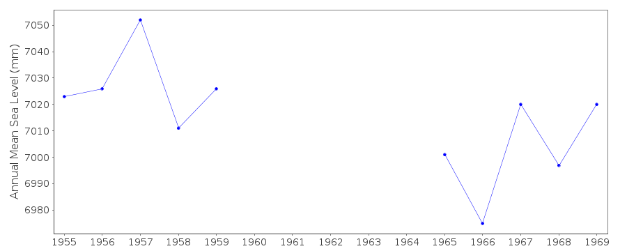 PSMSL Monthly Mean Sea Level for '745' 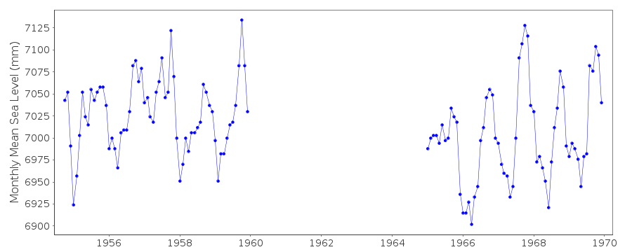
|
|
|