 |
SEALEVEL STATION CATALOG (SSC) |
|
|
|
|
|
| Station catalog metadata [edit] | [station overview] |
|---|
| SSC ID | SSC-balt | | Station Name | Baltra | | Country | Ecuador | | Latitude | -0.433 | | Longitude | -90.283 | | DateLastModified | 2015-10-22 19:02:29 |
| Linked codes |
|---|
| Codes | Location | Latitude | Longitude | Sensors | IOC: balt | Baltra,Galapagos_EC | -0.433 | -90.283 | prs, rad, ras, bat, sw1, sw2 |
GLOSS: 169 | Baltra, Galapagos Is. | -0.43333 | -90.28333 | Float, Pressure |
UHSLC: 3 | Baltra | -0.43656 | -90.28553 | N/A |
PTWC: balt | Baltra_Galapags_EC | -0.4367 | -90.2850 | prs, rad, enc |
PSMSL: 1226 | BALTRA-A | -0.433333 | -90.283333 | N/A |
PSMSL: 1645 | BALTRA-B | -0.433333 | -90.283333 | N/A |
| Distributed metadata source: IOC Sea Level Station Monitoring Facility balt |
|---|
| GTS station code | 932040EE |
| GTS message type | SEEQ40 |
| Status | Operational |
| Local Contact | Instituto Oceanográfico de la Armada ( Ecuador ) |
| Other Contact | University of Hawaii Sea Level Center ( USA ) |
| Connection | GTS message |
| Country | Ecuador |
| Sensor 1 | |
| Type of sensor | prs |
| Sampling rate (min) | 1 |
| Sensor 2 | |
| Type of sensor | rad |
| Sampling rate (min) | 1 |
| Sensor 3 | |
| Type of sensor | ras |
| Sampling rate (min) | 1 |
| Sensor 4 | |
| Type of sensor | sw1 |
| Sampling rate (min) | 60 |
| Sensor 5 | |
| Type of sensor | sw2 |
| Sampling rate (min) | 60 |
| Sensor 6 | |
| Type of sensor | bat |
| Sampling rate (min) | 5 |
| Distributed metadata source: GLOSS Station Handbook |
|---|
| Time Zone | 090W, GMT - 6hrs | | Ocean | Pacific | | Operational | Yes | | Responsible country | Ecuador | | Tide gauge benchmarks | UH-1: type not documented, located at 133ft, 40 deg. true N at SE corner of the fuel storage bldg. (established 24 Mar 1985) | | Benchmark relationships | Datum of data is zero of tide staff
UH-1 is 4.052m above tide staff zero (June 1985)
UH-2 is 4.189m above tide staff zero (June 1985)
| | Auxiliary benchmarks | UH-2: type not documented, located at 133.33ft, 40 deg. true N at SE corner of fuel bldg. (established 24 Mar 1985)
UH-3: SS square plate located at base of the old lamp post just off line between the station and the lighthouse, located 237 deg. true N and about 250 ft from tide station (established 8 Jun 1990)
1: type not documented, behind storage area (established Apr 1988)
| | Other relevant information | Other benchmarks:
2A - 10cm disc stamped 'Instituto Oceanografico de l'Armada. Prohibido Tocar 1977'. 234 deg. True N of tide station.
SW1 - head of 1/4inch screw mounted on witch switch on Encoder well.
(2A and SW1 established 8 Jun 1990)
| | Other relevant codes | UHSLC 003 |
| Distributed metadata source: PTWC COMP META file |
| DCP ID | 932040EE |
| WMO | SEEQ40 |
| Samp Rate | 5 |
| Num# Samp | 5 |
| Unit | M |
| Scale | 1.0000 |
| Xmt Int. | 005 |
| Fst Min. | 0002 |
| HAR | 1 |
| Owner | UHSLC |
| Distributed metadata source: UHSLC |
| UHSLC id | 003 |
| SSC id | balt |
| GLOSS id | 169 |
| UHSLC geojson | https://uhslc.soest.hawaii.edu/data/meta.geojson |
| Research quality data version a | 1968-06-01 - 1977-12-31 |
| Research quality data version b | 1985-03-25 - 2024-12-31 |
| RQ basin | pacific |
| Fast delivery | 1985-03-25 - 2026-05-31 |
| Distributed metadata source: PSMSL |
| Name | BALTRA-A |
| GLOSS id | 169 |
| UHSLC ID | 3 |
| Is RLR | N |
| Has RLR Diagram | N link |
| QC Flag | Y |
| Old ID | 845/033 |
| Last Updated | 1990-08-30 |
| Supplier | UNIVERSITY OF HAWAII SEA LEVEL CENTER |
| Address | University of Hawaii Sea Level Center, Department of Oceanography Division of Natural Sciences, 1000 Pope Road, Honolulu, Hawaii 96822, UNITED STATES |
| Metric Start | 1968 |
| Metric End | 1977 |
| Metric Completeness | 83.3 |
| Download metric sea level data. | Use only with extreme caution. |
| Name | BALTRA-B |
| GLOSS id | 169 |
| UHSLC ID | 3 |
| Is RLR | Y |
| Has RLR Diagram | Y link |
| QC Flag | N |
| Old ID | 845/034 |
| Last Updated | 2020-01-29 |
| Supplier | UNIVERSITY OF HAWAII SEA LEVEL CENTER |
| Address | University of Hawaii Sea Level Center, Department of Oceanography Division of Natural Sciences, 1000 Pope Road, Honolulu, Hawaii 96822, UNITED STATES |
| Metric Start | 1985 |
| Metric End | 2018 |
| Metric Completeness | 88.7 |
| RLR Start | 1985 |
| RLR End | 2018 |
| RLR Completeness | 88.7 |
| Download metric sea level data. | Use only with extreme caution. |
IOC Sea Level Station Monitoring Facility - realtime graph for 'balt' 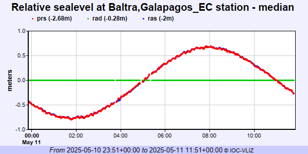 PSMSL Annual Mean Sea Level for '1226'  PSMSL Annual Mean Sea Level for '1645' 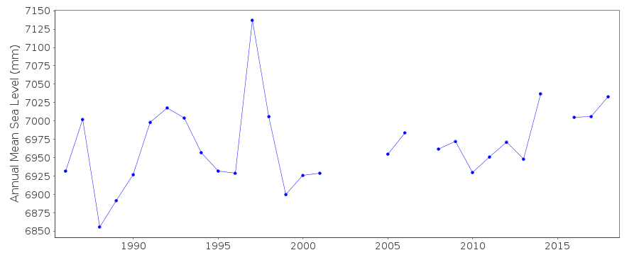 PSMSL Monthly Mean Sea Level for '1645' 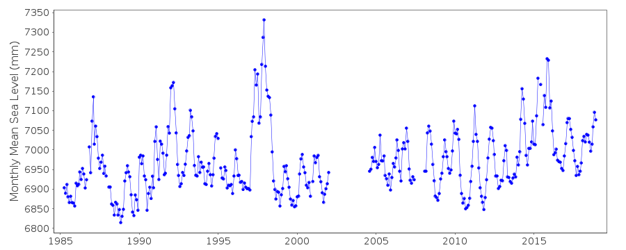
|
|
|