 |
SEALEVEL STATION CATALOG (SSC) |
|
|
|
|
|
| Station catalog metadata [edit] | [station overview] |
|---|
| SSC ID | SSC-anto | | Station Name | Antofagasta | | Country | Chile | | Latitude | -23.653133 | | Longitude | -70.404441 | | DateLastModified | 2015-10-22 19:02:29 |
| Linked codes |
|---|
| Codes | Location | Latitude | Longitude | Sensors | IOC: anto | Antofagasta_CL | -23.65421517 | -70.40462436 | prs, rad |
IOC: anto2 | Antofagasta_CL | -23.65421517 | -70.40462436 | prs, rad |
GLOSS: 174 | Antofagasta | -23.39 | -70.24 | Pressure |
UHSLC: 80 | Antofagasta | -23.65 | -70.4 | N/A |
PTWC: anto | Antofagasta_CL | -23.6542 | -70.4046 | prs, rad |
PSMSL: 510 | ANTOFAGASTA 2 | -23.653056 | -70.404444 | N/A |
PSMSL: 511 | ANTOFAGASTA | -23.65 | -70.416667 | N/A |
SONEL_GPS: 2608 | ANTOFAGAST | -23.68000000 | -70.41000000 | N/A |
SONEL_TG: 2607 | ANTOFAGAST | -23.65314200 | -70.40442400 | N/A |
SONEL_TG: 2753 | ANTOFAGAST | -23.65000000 | -70.41666700 | N/A |
| Distributed metadata source: IOC Sea Level Station Monitoring Facility anto |
|---|
| GTS station code | ADC0F6BA |
| GTS message type | SXCH40 |
| Status | Operational |
| Local Contact | Servicio Hidrográfico y Oceanográfico de la Armada ( Chile ) |
| Other Contact | Servicio Hidrográfico y Oceanográfico de la Armada ( Chile ) |
| Connection | GTS message |
| Country | Chile |
| Sensor 1 | |
| Type of sensor | prs |
| Sampling rate (min) | 1 |
| Sensor 2 | |
| Type of sensor | rad |
| Sampling rate (min) | 1 |
| Distributed metadata source: IOC Sea Level Station Monitoring Facility anto2 |
|---|
| Status | Operational |
| Local Contact | Servicio Hidrográfico y Oceanográfico de la Armada ( Chile ) |
| Other Contact | Servicio Hidrográfico y Oceanográfico de la Armada ( Chile ) |
| Connection | WEB service |
| Country | Chile |
| Sensor 1 | |
| Type of sensor | prs |
| Sampling rate (min) | 1 |
| Sensor 2 | |
| Type of sensor | rad |
| Sampling rate (min) | 1 |
| Distributed metadata source: GLOSS Station Handbook |
|---|
| Time Zone | 060W, GMT - 4hrs | | Ocean | Pacific | | Operational | Yes | | Responsible country | Chile | | Data acquisition rate | 2 minute intervals | | Additional parameters | Sea temperature (hourly)
Air temperature (hourly)
Atmospheric pressure (hourly) | | Tide gauge benchmarks | BM No. 10 - a 9cm bronze disk stamped CF6, set in cement in front the door of the tide house | | Benchmark relationships | BM No. 8A (1999-2003)
BM No. 6 (1950-2003)
BM No. 10 (1971-2003) | | Auxiliary benchmarks | BM No. 7 is a 9cm bronze disk stamped CF 7, set in cement sidewalk at the north side of the access to the port gate very close to check-in point.
BM No. 8A is a 7cm bronze disk stamped CF 8A, set in cement in front of the auxiliary of 'Gobernacion Maritima' building. | | Other relevant information | PSMSL also hold Data from another gauge at Antofagasta (PSMSL Code 850/ 011 1980-1990).
Levelling twice a year, no GPS recording. | | Other relevant codes | UHSLC 080 | | Nearest Met. station | Cerro Moreno Airport |
| Distributed metadata source: PTWC COMP META file |
| DCP ID | ADC0F6BA |
| WMO | SXCH40 |
| Samp Rate | 1 |
| Num# Samp | 5 |
| Unit | M |
| Scale | 1.0000 |
| Xmt Int. | 005 |
| Fst Min. | 0003 |
| HAR | 1 |
| Owner | SHOA |
| Distributed metadata source: UHSLC |
| UHSLC id | 080 |
| SSC id | anto |
| GLOSS id | 174 |
| UHSLC geojson | https://uhslc.soest.hawaii.edu/data/meta.geojson |
| Research quality data version a | 1945-12-07 - 2018-12-31 |
| RQ basin | pacific |
| Fast delivery | 1945-12-07 - 2026-04-30 |
| Distributed metadata source: PSMSL |
| Name | ANTOFAGASTA 2 |
| GLOSS id | 174 |
| UHSLC ID | 80 |
| SONEL id | 2608 |
| Is RLR | Y |
| Has RLR Diagram | Y link |
| QC Flag | N |
| Old ID | 850/012 |
| Last Updated | 2025-06-09 |
| Supplier | HYDROGRAPHIC AND OCEANOGRAPHIC SERVICE OF THE CHILEAN NAVY |
| Address | Hydrographic and Oceanographic Service of the Chilean Navy, Errazuriz 254, Playa Ancha , Valparaiso, CHILE |
| Metric Start | 1945 |
| Metric End | 2024 |
| Metric Completeness | 92.5 |
| RLR Start | 1945 |
| RLR End | 2024 |
| RLR Completeness | 92.5 |
| Download metric sea level data. | Use only with extreme caution. |
| Name | ANTOFAGASTA |
| GLOSS id | 174 |
| UHSLC ID | 80 |
| SONEL id | 2608 |
| Is RLR | Y |
| Has RLR Diagram | Y link |
| QC Flag | Y |
| Old ID | 850/011 |
| Last Updated | 1992-11-19 |
| Supplier | HYDROGRAPHIC AND OCEANOGRAPHIC SERVICE OF THE CHILEAN NAVY |
| Address | Hydrographic and Oceanographic Service of the Chilean Navy, Errazuriz 254, Playa Ancha , Valparaiso, CHILE |
| Metric Start | 1945 |
| Metric End | 1991 |
| Metric Completeness | 96.1 |
| RLR Start | 1945 |
| RLR End | 1991 |
| RLR Completeness | 96.1 |
| Download metric sea level data. | Use only with extreme caution. |
IOC Sea Level Station Monitoring Facility - realtime graph for 'anto' 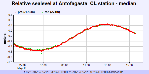 IOC Sea Level Station Monitoring Facility - realtime graph for 'anto2' 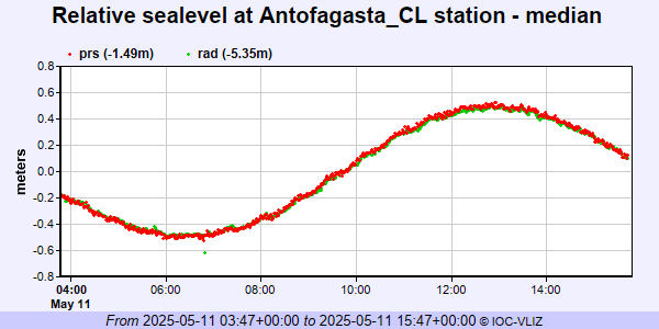 PSMSL Annual Mean Sea Level for '510' 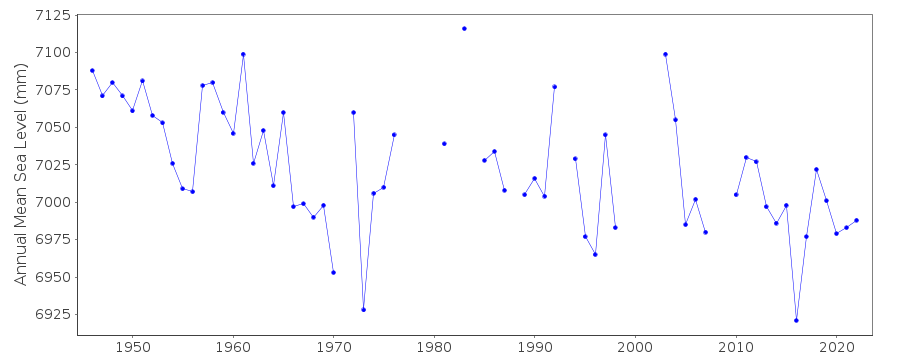 PSMSL Annual Mean Sea Level for '511' 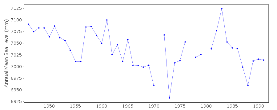 PSMSL Monthly Mean Sea Level for '511' 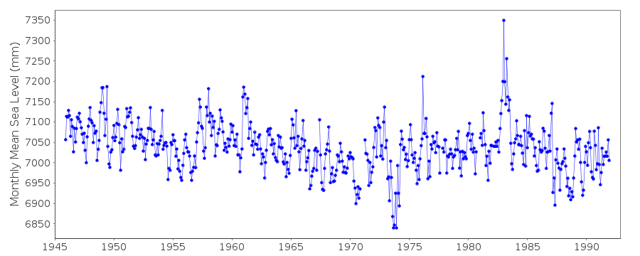
|
|
|