 |
SEALEVEL STATION CATALOG (SSC) |
|
|
|
|
|
| Station catalog metadata [edit] | [station overview] |
|---|
| SSC ID | SSC-alot | | Station Name | Alotau | | Country | Papua New Guinea | | Latitude | -10.31666 | | Longitude | 150.45 | | DateLastModified | 2015-10-22 19:02:29 |
| Distributed metadata source: GLOSS Station Handbook |
|---|
| Time Zone | 150E, GMT + 10hrs | | Ocean | Pacific | | Operational | No | | Responsible country | Australia | | Data acquisition rate | 15 minute sampling | | Tide gauge benchmarks | ALU 3 a brass rod set in concrete on the west side of the Overseas Shed. | | Benchmark relationships | Gauge datum is 3.255m below TGBM (Sep 1984-). | | Auxiliary benchmarks | ALU 4 a stainless steel rod in concrete footing on west side of Port Manager's Office.
ALU 5 a brass plaque stamped '9474', north west of Overseas Shed.
ALU 1 a stainless steel rod in concrete in SW corner of Overseas Wharf.
ALU 2 a stainless steel bolt set in concrete in the SW corner of the Harbours Board compound.
| | Other relevant information | Benchmarks ALU 1 and ALU 2 considered unstable 1990.
Float/stilling well analogue gauge operated at Alotau by Department of Public Works 1971-1973.
| | Other relevant codes | NTF port no. 55830, UHSLC 069 |
| Distributed metadata source: UHSLC |
| UHSLC id | 069 |
| SSC id | alot |
| GLOSS id | 63 |
| UHSLC geojson | https://uhslc.soest.hawaii.edu/data/meta.geojson |
| Research quality data version a | 1984-09-21 - 1995-02-24 |
| RQ basin | pacific |
| Distributed metadata source: PSMSL |
| Name | ALOTAU |
| GLOSS id | 63 |
| UHSLC ID | 69 |
| Is RLR | Y |
| Has RLR Diagram | Y link |
| QC Flag | N |
| Old ID | 670/006 |
| Last Updated | 2013-07-03 |
| Supplier | NATIONAL TIDAL CENTRE |
| Address | National Tidal Centre, Bureau of Meteorology, PO Box 421, Kent Town 5071, South Australia, AUSTRALIA |
| Metric Start | 1984 |
| Metric End | 1995 |
| Metric Completeness | 54.9 |
| RLR Start | 1984 |
| RLR End | 1995 |
| RLR Completeness | 54.9 |
| Download metric sea level data. | Use only with extreme caution. |
| Name | ALOTAU II |
| GLOSS id | 63 |
| UHSLC ID | 69 |
| Is RLR | N |
| Has RLR Diagram | N link |
| QC Flag | N |
| Old ID | 670/007 |
| Last Updated | 1993-05-24 |
| Supplier | NATIONAL TIDAL FACILITY |
| Address | National Tidal Facility, G.P.O. Box 2100, S.A. 5001, Adelaide , AUSTRALIA |
| Metric Start | 1984 |
| Metric End | 1990 |
| Metric Completeness | 57.1 |
| Download metric sea level data. | Use only with extreme caution. |
PSMSL Annual Mean Sea Level for '1607' 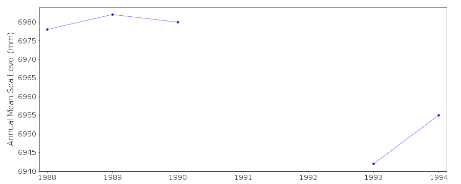 PSMSL Annual Mean Sea Level for '1616'  PSMSL Monthly Mean Sea Level for '1616' 
|
|
|